

Posted to Beaver Island Historical Society (Facebook page) by Beaver Island Historical Society on 2021-11-08 20:47:51.
Visual descriptionwritten by a machine · unchecked
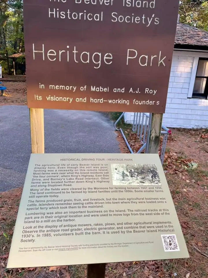
A large brown wooden sign with white lettering stands above a cream-colored interpretive panel. The panel contains several paragraphs of text, a small historical image, and a QR code. Trees, fallen leaves, a paved path, and part of a white shingled building are visible behind the signs.
A model wrote this. It was shown the image and the catalogue record together, and asked to keep them apart — what it saw is here, what the record told it is under "taken from the record" below. It is still wrong often enough to matter, about who is pictured, where, when, and what is happening. Read it as a way to find the image, never as evidence about it. If you can correct it, please do: write to michael.bommarito@gmail.com, or see how corrections work. Someone who recognises a face or a shoreline knows more than the model did.
Individual posters, credited per image
720 × 960 px · JPEG · 104 KB
Subjects and keywords
Text in the image
Transcribed from the object itself.
The Beaver
Island
Historical Society's
Heritage Park
in memory of Mabel and A.J. Roy
Its visionary and hard-working founders

HISTORICAL DRIVING TOUR - HERITAGE PARK

The agricultural life of early Beaver Island is on display here. Even though the soil was poor, farming was a necessity on this remote island. Most farms were near what the residents call 'the four corners,' where King's Highway, East Side Drive, and Barney's Lake Road intersect. Other farms were located further down King's Highway and along Sloptown Road.

Many of the fields were cleared by the Mormons for farming between 1847 and 1856. The land continued to be farmed by Island families until the 1950s. Some smaller farms still operate today.

The farms produced grain, fruit, and livestock, but the main agricultural business was cattle. Islanders remember seeing cattle driven into town when they were loaded onto a special ferry which took them to the mainland.

Lumbering was also an important business on the Island. The railroad tracks at this park are in their original location and were used to move logs from the west side of the Island for a mill on the harbor.

Look at the display of antique mowers, rakes, plows, and other agricultural implements. Observe the antique road grader, electric generator, and combine that were used in the 1930's. In 1985, volunteers built the barn. It is used by the Beaver Island Historical Society.
Taken from the record
Not observed in the image — supplied by the archive's own catalogue, and repeated here so the two stay distinguishable.
The catalogue identifies this as a photograph posted to the Beaver Island Historical Society Facebook page by the Beaver Island Historical Society on 2021-11-08. The archive record gives the filename 2021-11-08_1895049760703304.jpg.
Could not make out
Stated rather than guessed at.
The fine print at the bottom of the interpretive panel and the web address beside the QR code are too small to read fully.
Rights and credit
Community source, no stated terms; published non-commercially with attribution and a link to the original post.
Credit this to Individual posters, credited per image when you use it.
Why this archive publishes it. Public Facebook groups and pages run by island organisations and residents. Each item credits the poster by name and links to the original post. Removal on request.
Material goes off the web without anyone deciding that it should: a host lapses, a gallery is retired, a link stops resolving. Holding a copy — with its provenance, its checksum and its holder's terms recorded beside it — is much of why this archive exists. If you are looking for something whose original has since gone, write to michael.bommarito@gmail.com and a full-size copy of what is held here will be sent to you.
Recorded verbatim from the provenance sidecar taken at retrieval — this archive does not restate a holder's terms in its own words, does not add a restriction the holder did not state, and does not abridge one.
Provenance
- Held by
- Individual posters, credited per image
- Collection
- Community photographs — public Facebook groups and pages
- Original
- https://www.facebook.com/photo/?fbid=1895049760703304&set=pb.100063605411595.-2207520000
- Copy taken
- 2021-11-08
- Title from
- the note recorded at retrieval
The file
| Rendition | Format | Extent | Size | SHA-256 |
|---|---|---|---|---|
| Master | JPEG | 720 × 960 px | 104 KB | b7fc01225a1f… |
Checksums are the values recorded when each copy was taken.
Download
- Web-sized image720 × 960 · 83 KB · WebP
- The full-resolution original, from Individual posters, credited per image720 × 960 · 104 KB · JPEG
The archive holds its own copy of that file and will supply it on request; it is not re-served here, because the holder serves it better and a second copy is a second thing to go stale.
Cite this
“Posted to Beaver Island Historical Society (Facebook page) by Beaver Island Historical Society on 2021-11-08 20:47:51”. Individual posters, credited per image. Beaver Island Archive, https://beaverislandarchive.org/media/photograph/2021-11-08-1895049760703304/. copy retrieved 2021-11-08.
Built only from what the archive recorded: the names on the record, the title as recorded, the date if one was recorded, this page, and the date the copy was taken. Nothing is filled in to satisfy a citation style.