

- Date
- 1859-11-10
- Concepts
- land-surveymigrationheritage
- Within
- Beaver Island archipelago
Summary
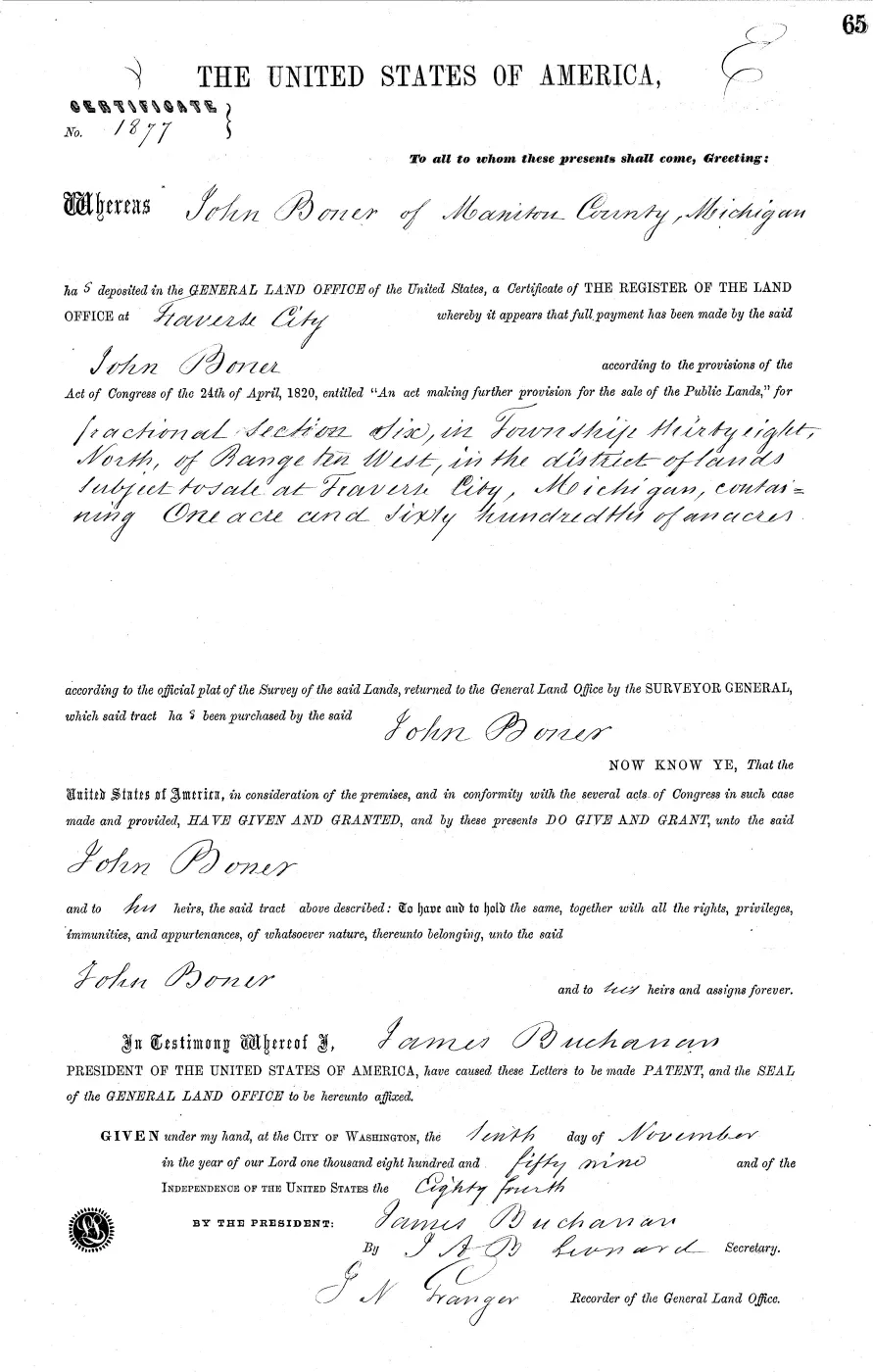
The General Land Office issued this patent to JOHN BONER on 10 November 1859, out of the Traverse City land office. The land is T38N R10W Section 6 — 38N10W6 on the Michigan Meridian (19) once the description is normalised. Its authority is Sale-Cash Entry, and the row cites April 24, 1820 (3 Stat. 566). Accession MI2390__.065 has this one location row, and the source reports 1.6000 acres for it.
Ownership evidence and limits
A patent records the moment the United States parted with the land, and stops there. Whatever happened afterwards sits in the county deed index rather than here. The grantee is the spelling a clerk wrote in 1859, and it stays a spelling until a separate identity record carries the link to a person or an organisation. A shared surname is not that record.
PLSS connections
- Quarter-quarter matches: PLSS quarter-quarter 38N10W06NENE, PLSS quarter-quarter 38N10W06NWNE, PLSS quarter-quarter 38N10W06NENW, PLSS quarter-quarter 38N10W06NWNW, PLSS quarter-quarter 38N10W06SENE, PLSS quarter-quarter 38N10W06SWNE, PLSS quarter-quarter 38N10W06SENW, PLSS quarter-quarter 38N10W06SWNW
- Section: PLSS section 06, MI190380N0100W0
- Held survey plat: GLO survey plat: T38N R10W
Open questions
- Does the county deed index record a conveyance out of this patent?
- Does any held record identify JOHN BONER beyond this spelling?
See also
- BLM General Land Office patent records for the Beaver Island area
- Land survey and settlement geography
- PLSS quarter-quarter 38N10W06NENE
- PLSS quarter-quarter 38N10W06NWNE
- PLSS quarter-quarter 38N10W06NENW
- PLSS quarter-quarter 38N10W06NWNW
- PLSS quarter-quarter 38N10W06SENE
- PLSS quarter-quarter 38N10W06SWNE
- PLSS quarter-quarter 38N10W06SENW
- PLSS quarter-quarter 38N10W06SWNW
- PLSS section 06, MI190380N0100W0
- GLO survey plat: T38N R10W
The page
Rendered from the held scan.
Sources
- Source row 256; record type 'Patent'; grantee/patentee field preserved as 'JOHN BONER'; legal description preserved as 'T38N R10W Section 6'; normalized PLSS key 38N10W6; accession 'MI2390__.065'; patent class 'State Volume'; authority 'Sale-Cash Entry'; issuing land office 'Traverse City'; patent-wide acres '1.6000'. Legal-description note ''. This is a source-record assertion about the recorded grantee or patentee, not a claim about subsequent conveyances or current ownership. The holder's public portal is searchable but does not link this record directly; the archive holds a copy of the file and can provide it on request.federal · glo · beaver_island_patent_locations
- Held patent image for the source record; the temporary public image-delivery token is not retained. The holder's public portal is searchable but does not link this record directly; the archive holds a copy of the file and can provide it on request.federal · glo · patents · 6127363345490425847-patent-sta-mi2390-065
Added 1 August 2026 · revised 3 August 2026. Recent changes
Cite this article
Beaver Island Archive, “GLO land record MI2390__.065-38n-10w-6-section”, https://beaverislandarchive.org/documents/glo-patent-mi2390-065-38n-10w-6-section/, accessed [date], citing Bureau of Land Management, General Land Office Records, Michigan land-record export. (and 1 further source listed on the page).
Last revised 2026-08-03. Fill in [date] with the date you read it — this page is static and cannot know that.
BibTeX for “GLO land record MI2390__.065-38n-10w-6-section”RIS for “GLO land record MI2390__.065-38n-10w-6-section”