

- Eras
- Early American eraStrang eraIrish era
- Concepts
- land-surveymigrationtoponymyenvironmentheritageEarly American eraStrang eraIrish era
- Within
- Beaver Island archipelago
Summary
The archipelago’s settlement geography has two different federal records behind it. The survey plats lay out the public-land framework; patents and tract books record conveyances and entry history. The project now holds 13 survey plats, modern PLSS geometry, 412 patents represented by 748 legal-location rows, and two linked BLM field-note volumes totaling 1,432 page images. Tract books remain open; the field-note volumes are page-indexed but mostly not visually transcribed.
This distinction matters because a section line, a place name, and a family name do not prove the same thing. The GLO plats show how the islands were divided and what features surveyors labeled. The land-cover reconstruction uses those surveyors’ notes to reconstruct vegetation. Neither layer identifies a first private owner. The patent layer does identify a recorded patentee and issuance date, but it does not prove residence, continuous ownership, or a later chain of title.
The held plats
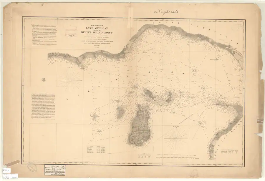
Thirteen held plats cover the island townships and adjacent sections represented in the project collection. Their circa-1849 federal survey context overlaps the Strangite occupation rather than following it by decades. The plat labels BIG BEAVER I. and GARDEN ISLAND therefore belong to the same historical map world as the Strang-era names preserved in the 1853 Farmer map and the 1855 Lake Survey chart.
Reconciling record dates
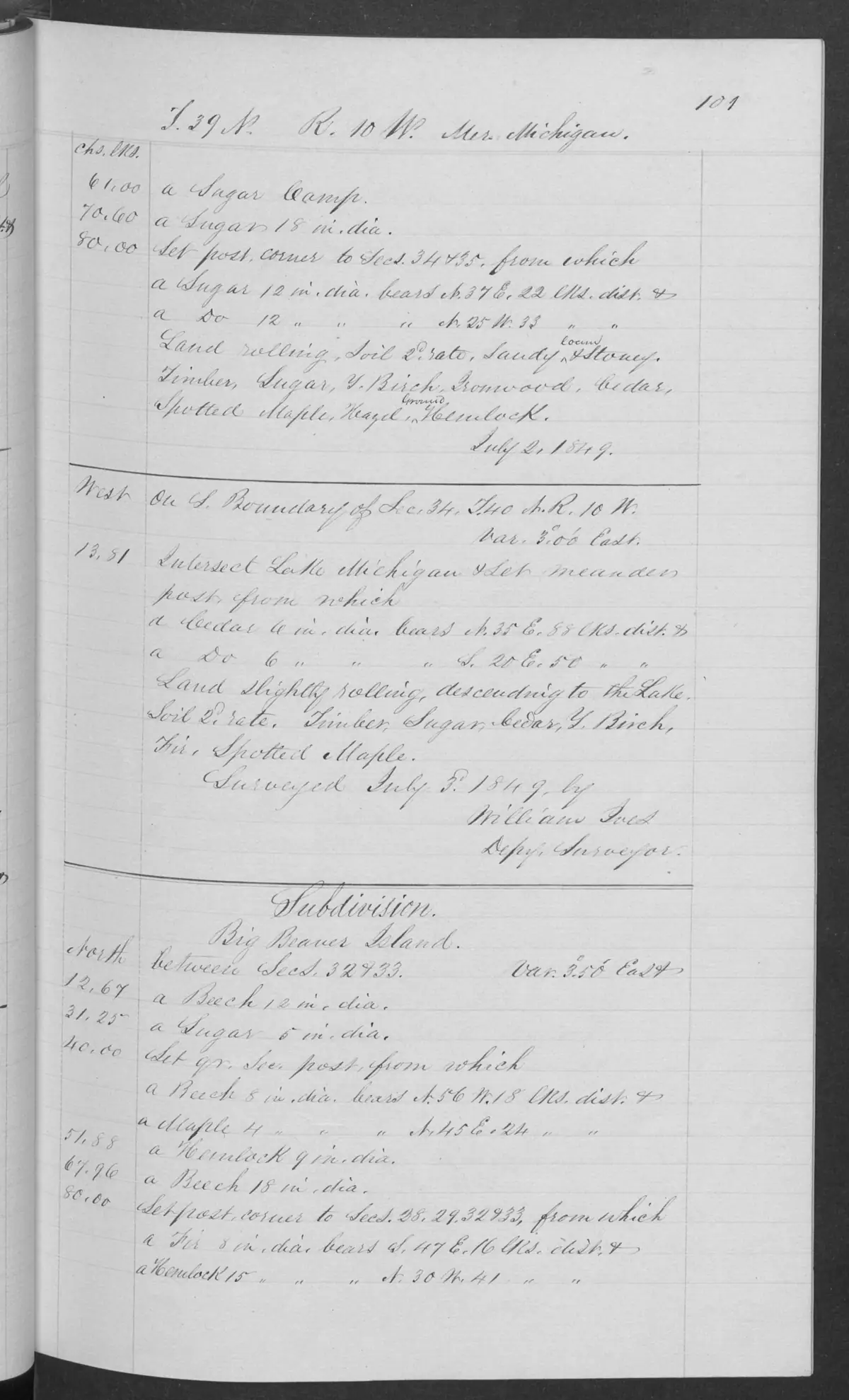
Survey metadata, pages, and plats are related records, not interchangeable date authorities. A checked T39N R10W field-note page is dated 3 July 1849 and begins a Big Beaver Island subdivision, while the BLM metadata for its linked Survey-31656 record supplies 25 September 1845 as “Survey Commenced.” The project retains both values and their relationship but does not combine them into a single asserted fieldwork interval. Any chronology needs to say which record it relies on and resolve the discrepancy from the primary sequence, not silently privilege a database field over a dated page image.
The modern federal and Michigan layers make the survey legible in GIS. The held state layers include township/range, section, and quarter-quarter polygons; those are join geometry, not evidence that a named person owned a particular aliquot. A future patent table can be joined on survey identifiers, not on family-name similarity.
Structured section-record fan-out
The knowledge base now has 146 source-record articles, one for each unique federal PLSS section geometry in the held archipelago extract. Each record keeps the federal section identifier, township/range label, representative coordinate, and computed area, then points back to the GLO plat collection and the environmental baseline. The records make the future patent and plat comparison searchable without converting survey geometry into an unsupported ownership claim.
Aliquot and current-parcel fan-out
The state quarter-quarter layer is now indexed as 1,489 aliquot-part records,
one per unit — the smallest
survey units in the held state geometry and the most useful join target for a
future patent or deed. The source’s categorical OWNERSHIP field is preserved
as a source value, not interpreted as a person or title.
The current DNR layer contributes 745 parcel records. Their legal descriptions, ParIDs, acreage, and division/department labels can identify candidate state-managed land and provide language for a county-record request; they do not contain a complete private-owner or deed chain. The separate current-place layer adds 36 OSM named/island/historic feature records with spatial links to the survey and parcel records.
Together the layers give the ownership question somewhere to land: a future patent, deed, tax card, or institutional acquisition can be attached to a stable PLSS aliquot or legal-description candidate. Proximity, a surname, and a map label still prove nothing on their own. The active leads are collected in Historical propertyholder and ownership research queue.
Plat-specific scan records
The 11 individual GLO sheets each have their own source-record article. Their observations preserve the township and range title, named island labels, and visible section-line context. Two later sheets require separate chronology: T39N R09W includes the 1942 survey and 1943 acceptance of a Pismire Island plat, while T39N R10W includes a 1954 supplemental plat for Section 11 based on the 1849 survey. These are document dates, not evidence of parcel ownership.
The plat records now connect outward to their matching federal section records, the intersecting circa-1800 land-cover units, GNIS name records within the modern township geometry, neighboring held sheets, and the 1855 Lake Survey chart. Every one of those links is typed as a comparison path, not as an assertion that the two records describe the same ground.
Settlement questions the current evidence can answer
The held maps can establish the timing and vocabulary of federal survey representation, compare historical and modern feature names, and locate the survey framework beneath later roads, forests, and parcels. They can also help test whether a name such as Font Lake appears in a federal plat before or after the 1853 Farmer map.
The held patents can now answer who received a federal conveyance, when it was issued, under which authority, and which legal descriptions the record lists. They cannot establish that the patentee occupied the land or remained its owner, and they do not replace county deeds, tax rolls, or tract books. The retained tract-book page layer can guide entry-history review, but its pages remain untranscribed and its index locations are not person or title assertions. Held field notes document survey observations, but do not establish title or occupation.
Open questions
- Which patent grantees can be resolved to documented island residents without relying on surname alone?
- What do visually checked tract-book pages add about entry, cancellation, relinquishment, and chronology before patent issuance?
- Which currently unreviewed pages in the held field-note volumes preserve vegetation, trails, camps, or place names absent from the plat images?
- Can the plat title blocks establish a precise survey chronology for each township?
- Which modern parcel and DNR-land boundaries can be compared responsibly with the historical survey sections?
See also
Sources
- General Land Office survey plats for the Beaver Island archipelago, Michigan DNR State Spatial Data Library, retrieved 2026-07-31.Described in this archive: General Land Office survey plats for the Beaver Island archipelago.Thirteen held plat scans provide the early federal survey map and historical labels, including Fox township sheets T34N R13W and T35N R13W; they are not ownership records. No public copy of this file is known; the archive holds one and can provide it on request.federal · glo_plats
- Machine-readable federal PLSS layers provide township, section, and intersected-feature geometry for the archipelago.federal · plss
- State layers preserve the finer quarter-quarter geometry needed for a future patent join, without asserting ownership.state · michigan
- The environmental reconstruction is based on original GLO surveyors' section-line notes; it is evidence of recorded vegetation, not a parcel-ownership dataset.state · michigan · land_cover_circa_1800
- Described in this archive: North End of Lake Michigan Including the Beaver Island Group, 1855 Lake Survey chart.The later chart supplies an independent cartographic comparison for the surveyed island outline, names, harbor, and surrounding waters.federal · noaa_charts · images · 1855_NORTH-END-OF-LAKE-MICHIGAN-INCLUDING-THE-BEAVER-ISLAND-GROUP-NORTH-END_LC00010-00-1855WWL
- Described in this archive: BLM General Land Office patent records for the Beaver Island area.The held extract contains 412 patents and 748 legal-location rows joined to the island PLSS grid. A separate tract-book page collection is held but remains untranscribed. Two linked BLM field-note volumes are held and page-indexed, but provider OCR is discovery-only and most page images have not been visually transcribed. The holder's public portal is searchable but does not link this record directly; the archive holds a copy of the file and can provide it on request.federal · glo · beaver_island_patent_locations
- Described in this archive: BLM GLO tract-book pages for the Beaver Island survey footprint.126 page-index records are retained; 80 public image PDFs are held and 46 records have no public image URL. The collection is a review layer, not a transcription, title chain, or complete image set. The holder's public portal is searchable but does not link this record directly; the archive holds a copy of the file and can provide it on request.federal · glo_tractbooks · beaver_island_tractbook_pages
- Described in this archive: BLM GLO field-note volumes linked to Beaver Island-area surveys.Two held BLM field-note volumes total 1,432 page images. A reproducible 218-page island-linked index is a review queue, not a transcription; page-specific readings require visual verification.federal · glo_field_notes
- Described in this archive: GLO field-note page: Big Beaver Island subdivision, 1849.A visually checked page identifies a T39N R10W Big Beaver Island subdivision on 3 July 1849, while linked Survey-31656 metadata records a 25 September 1845 commencement. The discrepancy is preserved, not normalized into one date.federal · glo_field_notes · page_evidence · field-note-volume-168138-page-0101-big-beaver-subdivision

Added 1 August 2026 · revised 2 August 2026. Recent changes
Cite this article
Beaver Island Archive, “Land survey and settlement geography”, https://beaverislandarchive.org/themes/land-survey-and-settlement-geography/, accessed [date], citing General Land Office survey plats for the Beaver Island archipelago, Michigan DNR State Spatial Data Library, retrieved 2026-07-31. (and 8 further sources listed on the page).
Last revised 2026-08-02. Fill in [date] with the date you read it — this page is static and cannot know that.
BibTeX for “Land survey and settlement geography”RIS for “Land survey and settlement geography”