

- Date
- 1849-07-03
- Eras
- Early American eraStrang era
- Concepts
- land-surveyheritageenvironmenttoponymy
- Within
- Beaver Island
Summary
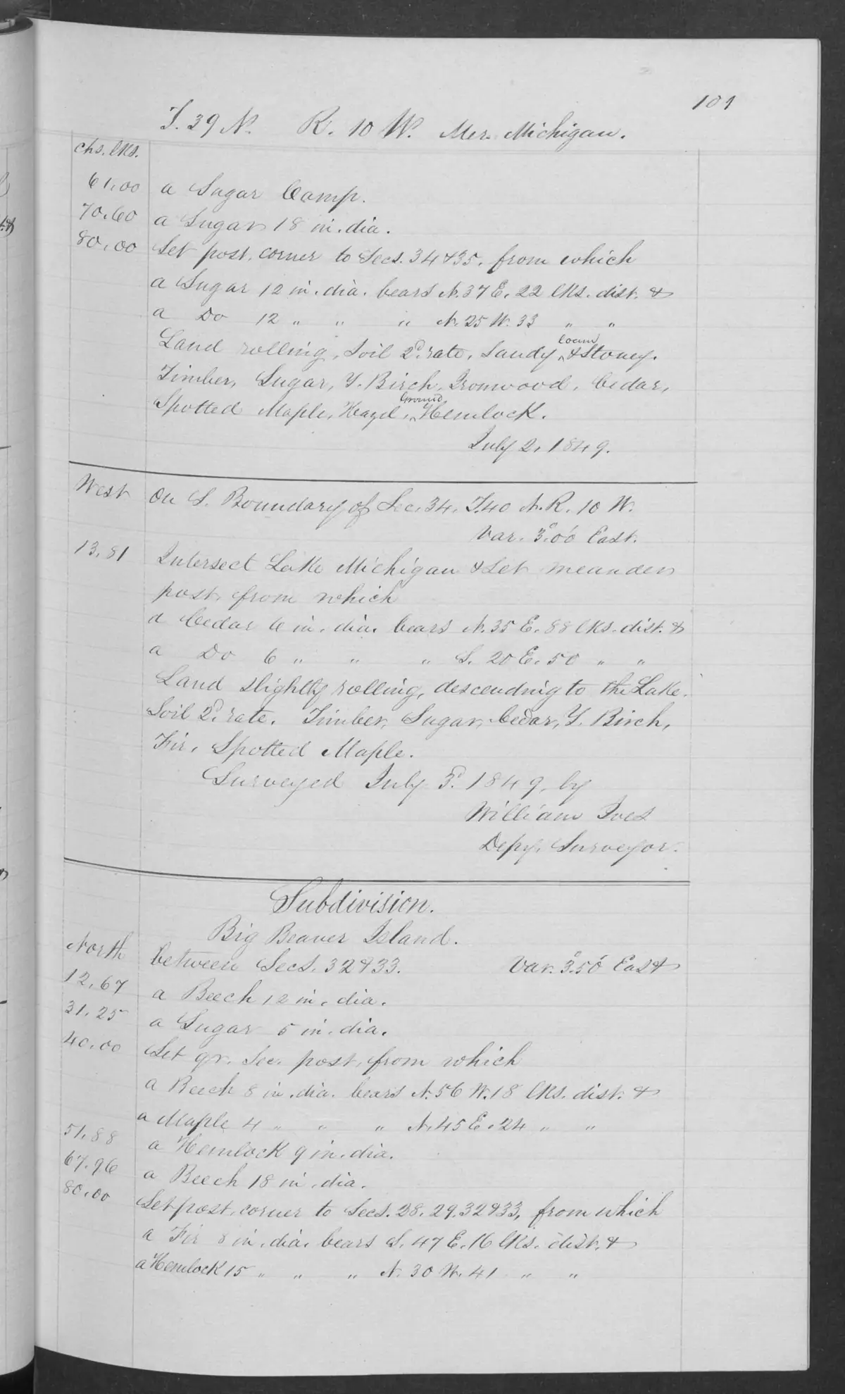
This visually checked page from the held federal Field Note Volume 168138 is headed T39N R10W and dated 3 July 1849. Its lower half explicitly begins “Subdivision. Big Beaver Island” and records the opening of a section-line sequence between sections 32 and 33. It therefore ties the historical Big Beaver Island form to a specific, dated page in the federal survey record.
Evidence and limits
The page establishes a bounded survey observation and the page’s own historical name form. Its legible date conflicts with the commencement date in the linked BLM Survey-31656 metadata, so this entry preserves the records separately rather than assigning an undifferentiated date to the full operation. A section-line notation does not demonstrate a present parcel boundary, a chain of title, land ownership, residency, access, or the whole island’s environmental condition.
See also
Sources
- Described in this archive: BLM GLO field-note volumes linked to Beaver Island-area surveys.Visual page-image verification. The handwritten page is headed T39N R10W and dated 3 July 1849. Its lower portion explicitly begins “Subdivision. Big Beaver Island” and records a section-line sequence between sections 32 and 33. The page is evidence of a dated federal-survey operation and historical name form, not proof of modern parcel boundaries, ownership, title, residence, access, or a complete environmental inventory.federal · glo_field_notes · page_evidence · field-note-volume-168138-page-0101-big-beaver-subdivision
- Held sanitized BLM detail metadata identifies a Survey of Islands for T39N R10W, calls it “BIG BEAVER ISLAND,” links it to Field Note Volume 168138, and records “Survey Commenced” 25 September 1845. That metadata date conflicts with the directly legible 3 July 1849 date on this page; the sources are retained as a provenance discrepancy, not combined into one unqualified fieldwork date. The holder's public portal is searchable but does not link this record directly; the archive holds a copy of the file and can provide it on request.federal · glo_surveys · beaver_island_surveys
Added 2 August 2026. Recent changes
Cite this article
Beaver Island Archive, “GLO field-note page: Big Beaver Island subdivision, 1849”, https://beaverislandarchive.org/documents/glo-field-note-big-beaver-subdivision-1849/, accessed [date], citing Bureau of Land Management, General Land Office Records, Field Note Volume 168138, p. 0101, T39N R10W, 3 July 1849. (and 1 further source listed on the page).
Last revised 2026-08-02. Fill in [date] with the date you read it — this page is static and cannot know that.
BibTeX for “GLO field-note page: Big Beaver Island subdivision, 1849”RIS for “GLO field-note page: Big Beaver Island subdivision, 1849”