

- Date
- 1755
- Eras
- Early American era
- Concepts
- toponymyheritageEarly American era
- Within
- Beaver Island archipelago
Summary
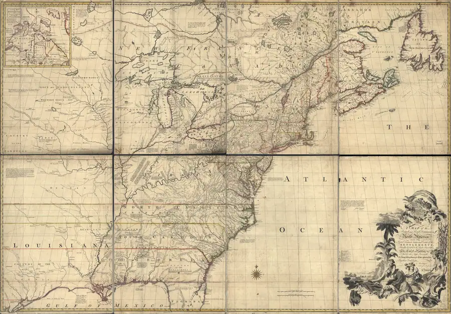
John Mitchell’s A Map of the British and French Dominions in North America (1755) prints Beaver I. in northern Lake Michigan. It is the earliest English form of the name documented in this archive, eleven years after Bellin’s French I. du Castor — see the toponymy survey for the sequence.
The archive holds a Library of Congress crop covering the northern lake, not the full sheet. Everything described here is read from that crop.
What the crop shows
Beaver I. is lettered in open water in the north-centre of the lake, west of the Michigan shore and south-west of the straits at Missilimakinac. Around the label the engraver has drawn a scatter of small islands rather than a single body — so the printed name is singular while the drawing is plural, and the sheet does not say which of the marks the name attaches to.
Its neighbours on the crop place it. Poutewatamis Islands is lettered as a named group to the north-west, with Noquets Bay and Noquets R. on the west shore beyond. St. Helena I. and St. Ignace sit at the straits, with Mission of St. Mary and the note “Old Settlement of the French Abandond” (sic) above them, and Manitoualin Isle to the east.
The east shore of the lake is drawn in far more detail than the islands, with a run of named rivers southward — Buscies, Oulemaniti, Marquettes, St. Nicholas, Sable, White, Maticon, Great, Raisin, Barbue, Black — and Port Chicagou at the foot of the lake. Dashed lines carry distance annotations in miles and leagues.
Where his information came from
The crop is worth reading for its imbalance. Around the Green Bay side — lettered Bay Puans — Mitchell prints peoples and posts: Sakis, Malomines, Mascoutens, Octagros, a Fort, the Mission of St. Francis Xavier, and the waters L. Kitchigamin, Miskouakimina and Mellaki R. East of the lake he prints almost no settlement at all, but names a dozen rivers in sequence down the shore. South-east he has Saguinam Bay, Utawas, A Great Elevation, F. Pontchartrain, St. Clair, and villages of the Poutewatamis, Hurons and Utawas.
That is the signature of a compiler working from other men’s routes. Where the French had missions, posts and traffic, the map carries names of places and peoples; where they merely coasted, it carries a list of river mouths; and in the open lake, where nobody’s route ran, it carries a scatter of unlabelled marks and the single name Beaver I. The islands are thinly drawn not because they were unimportant but because the map is built from journeys, and no journey in Mitchell’s material went through them.
Reading it as evidence
This is a claim map before it is a survey. Its own title sets British dominions against French ones, and the sheet is tinted along coasts and boundaries to argue that case; the large lettering across the Michigan interior concerns the Six Nations and their asserted league rather than the country drawn. Mitchell was compiling from other people’s material — the same body of French manuscript and Jesuit report that Charlevoix and Bellin drew on — not sailing this coast.
So the crop establishes one thing firmly and little else: the English form Beaver I. was in print by 1755. It does not establish which modern island the name meant, does not fix a boundary for the group now called the Beaver Island archipelago, and is no evidence at all of ordinary local usage. The people living on and around Beaver Island when this was engraved were Anishinaabe, their own naming is not what Mitchell printed, and none of it is settled by a label on a London map arguing about empires — see Anishinaabe presence in the archipelago.
Open questions
- Only a Library of Congress crop of the northern lake is held; the full sheet has not been examined for other Great Lakes detail relevant to this archipelago.
- Which of the unlabelled scattered marks around “Beaver I.” the engraver meant to distinguish, if any, is not resolved from the crop.
- Mitchell’s specific manuscript or printed sources for this stretch of coast have not been traced beyond the general observation that he compiled from others’ material.
See also
Sources
- Held Library of Congress crop visibly preserves “Beaver I.” in northern Lake Michigan. It supports an early English cartographic form, not a particular modern boundary, local usage, title, or full geographic inventory.maps · loc · mitchell_1755_ar003900 · beaver_label_crop
- Project provenance sidecar for the Mitchell 1755 Beaver-label crop.Records the Library of Congress IIIF source URL, retrieval timestamp, checksum, file size, and public-domain status. No public copy of this file is known; the archive holds one and can provide it on request.maps · loc · mitchell_1755_ar003900 · beaver_label_crop.provenance

Added 2 August 2026 · revised 4 August 2026. Recent changes
Cite this article
Beaver Island Archive, “John Mitchell map of North America, 1755”, https://beaverislandarchive.org/documents/john-mitchell-map-of-north-america-1755/, accessed [date], citing John Mitchell, *A Map of the British and French Dominions in North America* (1755), Library of Congress copy 1. (and 1 further source listed on the page).
Last revised 2026-08-04. Fill in [date] with the date you read it — this page is static and cannot know that.
BibTeX for “John Mitchell map of North America, 1755”RIS for “John Mitchell map of North America, 1755”