

- Date
- 1912
- Eras
- Modern era
- Concepts
- maritimeshippingheritage
Summary
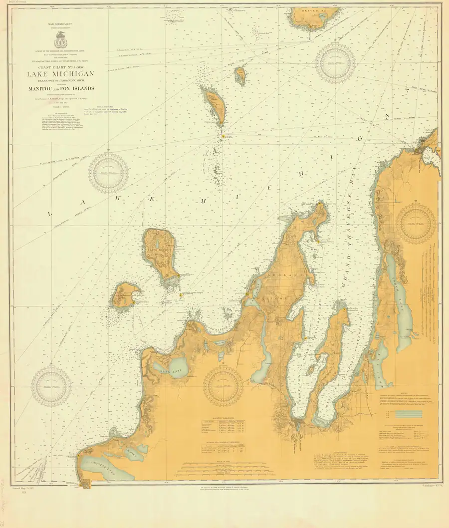
This held NOAA chart is the 1912 Lake Michigan—Frankfort to Charlevoix, Mich., including Manitou and Fox Islands (LS78), cataloged at 1:120,000. It provides a single navigational frame that visibly includes both North Fox Island and South Fox Island, the adjacent lower-peninsula coast, and the southern portion of Beaver Island.
That coverage matters as cartographic context: it places the Fox Islands in the same early-twentieth-century Lake Michigan navigational field as Beaver Island, while the chart title separately names the Manitou and Fox islands. It does not make a claim about shared county jurisdiction, culture, land ownership, or a formal definition of the Beaver archipelago.
Evidence and limits
The chart image, catalog, and provenance establish the edition’s title, date, chart number, scale, stated coverage, public-domain status, and held file. The visual review establishes that the labeled Fox islands and the southern part of Beaver Island appear on this sheet. It is a dated nautical chart, not a current navigation aid, boundary record, title record, or complete account of settlement, shipping activity, or every feature it depicts.
Individual soundings, symbols, shoreline details, aids to navigation, and revision notices need a direct reading of the full-resolution edition and, where material, independent corroboration before supporting a separate historical claim.
See also
Sources
- Held full-resolution NOAA chart image. The catalog identifies it as a 1912 nautical chart, chart LS78, at scale 1:120,000, with the stated Frankfort–Charlevoix / Manitou-and-Fox coverage. Direct visual review confirms that the sheet also shows the southern portion of Beaver Island. This record does not transcribe individual soundings, aids, corrections, or navigational instructions.federal · noaa_charts · images · 1912_LAKE-MICHIGAN-FRANKFORT-TO-CHARLEVOIX-MICH-INCLUDING-MANITOU-AND-FOX-I_78-5-1912
- Project provenance sidecar for NOAA chart LS78.Records the source URL, 2026-07-28 retrieval timestamp, checksum, 27,288,267-byte file size, and NOAA public-domain status. No public copy of this file is known; the archive holds one and can provide it on request.federal · noaa_charts · images · 1912_LAKE-MICHIGAN-FRANKFORT-TO-CHARLEVOIX-MICH-INCLUDING-MANITOU-AND-FOX-I_78-5-1912.provenance
- Catalog metadata gives the 1912 year, nautical-chart type, chart number LS78, scale 1:120,000, title, and catalog bounding box. The catalog does not prove the meaning or current status of every depicted feature.federal · noaa_charts · noaa_chart_catalog

Added 2 August 2026 · revised 4 August 2026. Recent changes
Cite this article
Beaver Island Archive, “Lake Michigan—Frankfort to Charlevoix, including Manitou and Fox Islands, 1912”, https://beaverislandarchive.org/documents/noaa-lake-michigan-manitou-fox-chart-1912/, accessed [date], citing NOAA Office of Coast Survey, Historical Map & Chart Collection, Lake Michigan—Frankfort to Charlevoix, Mich., including Manitou and Fox Islands, chart LS78, 1912. (and 2 further sources listed on the page).
Last revised 2026-08-04. Fill in [date] with the date you read it — this page is static and cannot know that.
BibTeX for “Lake Michigan—Frankfort to Charlevoix, including Manitou and Fox Islands, 1912”RIS for “Lake Michigan—Frankfort to Charlevoix, including Manitou and Fox Islands, 1912”