

- Date
- 2002-08-28
- Along road
- Donegal Bay Road · King's Highway · Main Street
- Eras
- Modern era
- Concepts
- governancetransportation
- Within
- Township of Saint James
Summary
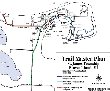
This retained St. James Township schematic map labels a Trail Master Plan for Beaver Island. Its legend distinguishes several depicted trail categories from a red “Proposed Donegal Bay Trail Proposed 2002” alignment. The map therefore records a planning proposal and a contemporary way of representing the local trail network; it does not prove a constructed route.
Context
The map connects the older proposed Donegal Bay trail idea with the later, separately documented 2024–25 discussion of preliminary engineering for a Donegal Bay Road bike-path extension. The two records show continuity of a planning subject, not continuity of an approved alignment, funding, or construction program. St. James reports preliminary engineering for Donegal Bay Road bike-path extension, 2024
Evidence and limits
The source is a low-resolution web image whose map labels and legend are visually legible. It does not identify the preparer, adoption action, meeting at which it was approved, scale, route geometry, land ownership, easements, engineering specifications, construction dates, current access, or the status of other depicted trails.
Open questions
- Who prepared this Trail Master Plan and at what meeting, if any, was it adopted? No preparer or adoption record survives with the retained image.
- Was the Proposed Donegal Bay Trail shown here ever constructed, or does the project not resume until the 2024 preliminary-engineering discussion?
If you can answer any of these, or correct anything above, the archive wants to hear it — see Corrections.
See also
Sources
- Visual verification of the held 450×374-pixel image at /data1/beaver-island-archive/websites/www.beaverisland.net/raw/Projects/Donegal_Bike_Path/beaver-island-trail-masterplan-8-28-02.gif. The legend depicts King’s Highway Pedestrian Trail, Bluff Trail 1997, Big Harbor Nature Preserve Trail, Beaver Island 2001, Main Street Pedestrian Trail, and a red “Proposed Donegal Bay Trail Proposed 2002.” It is a schematic planning map, not a survey, adopted ordinance, route/easement record, funding record, construction record, or proof that any depicted trail was open.maps · cited · www.beaverisland.net · beaver-island-trail-masterplan-8-28-02
Added 2 August 2026 · revised 4 August 2026. Recent changes
Cite this article
Beaver Island Archive, “St. James Township Trail Master Plan map, 2002”, https://beaverislandarchive.org/documents/st-james-trail-master-plan-2002/, accessed [date], citing St. James Township, Trail Master Plan, Beaver Island, Michigan, retained web image dated in filename 2002-08-28..
Last revised 2026-08-04. Fill in [date] with the date you read it — this page is static and cannot know that.
BibTeX for “St. James Township Trail Master Plan map, 2002”RIS for “St. James Township Trail Master Plan map, 2002”