

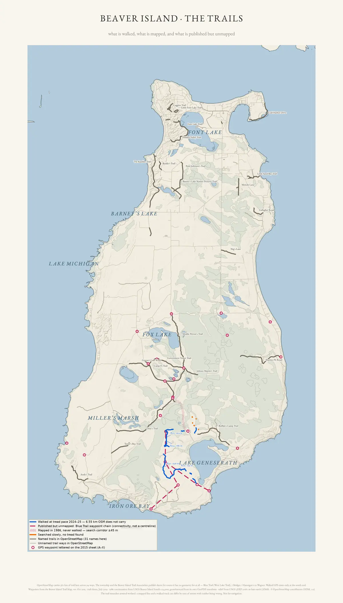
What is walked, what is mapped, and what is published but unmapped. OpenStreetMap carries 58.1 km of named trail here across 94 ways; the township and the trail association publish sheets for routes it has no geometry for at all, drawn as a waypoint chain rather than a centreline. Walked GPS exists only at the south end. Relief is the 2018 bare-earth lidar hillshade, which finds old grades the modern map omits — and which missed seven of the twelve GPS-confirmed runs, so an absence here is not evidence of absence on the ground. Not for navigation.
Drawn from the archive's own data in EPSG:3078. Map data © OpenStreetMap contributors (ODbL 1.0); relief USGS 3DEP 2018 1 m bare-earth lidar (public domain); 1986 continuation from USGS Beaver Island South 1:24,000 (public domain); waypoints transcribed from the Beaver Island Trail Map, rev. October 2015.
2,420 × 4,253 px · PNG · 2.7 MB
Rights and credit
CC BY 4.0 for the drawing; underlying data under its own terms (see credit)
Credit this to Drawn from the archive's own data in EPSG:3078. Map data © OpenStreetMap contributors (ODbL 1.0); relief USGS 3DEP 2018 1 m bare-earth lidar (public domain); 1986 continuation from USGS Beaver Island South 1:24,000 (public domain); waypoints transcribed from the Beaver Island Trail Map, rev. October 2015. when you use it.
Stated by this archive, which drew the plate.
Provenance
- Held by
- Beaver Island Archive
- Collection
- Atlas plates
- Drawn by
- scripts/make_trail_map.py
- Title from
- this archive, which drew the plate
The file
| Rendition | Format | Extent | Size | SHA-256 |
|---|---|---|---|---|
| Master | PNG | 2,420 × 4,253 px | 2.7 MB | 89e0d7f42a8f… |
Checksums are the values recorded when each copy was taken, or computed from the bytes held where the retrieval recorded no checksum for that particular file.
Download
- Web-sized image1200 × 2109 · 99 KB · WebP
- Print PNG2.7 MB
- Print PDF19.4 MB
In this archive
- Written aboutBeaver Island: the trails
- DepictsBeaver Island
- Published onAtlas
- Published on/themes/trails-and-trail-making/
Cite this
“Beaver Island: the trails”. Beaver Island Archive. Beaver Island Archive, https://beaverislandarchive.org/media/plate/beaver-island-trails/.
Built only from what the archive recorded: the names on the record, the title as recorded, the date if one was recorded, this page, and the date the copy was taken. Nothing is filled in to satisfy a citation style.