

- Date
- 1688
- Eras
- French era
- Concepts
- toponymyheritageFrench era
- Within
- Beaver Island archipelago
Summary
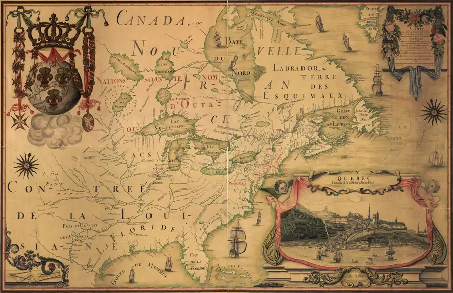
The held 1688 Franquelin map depicts the Beaver Island group in its regional Great Lakes setting but does not print a Beaver/Castor name for it. This matters as a boundary on the documented chronology of the name: it is evidence of a depicted group without that particular surviving cartographic label, not evidence that the name did not exist in speech or other records.
Evidence and limits
The identification is approximate and map-scale-bound. The source does not settle a modern island-by-island match, document community self-identification, or establish an origin date for the later French Beaver name.
Open questions
- Franquelin’s specific manuscript sources for this stretch of the lake have not been traced beyond the general body of French charts and reports he compiled from.
- The island-by-island count within the drawn group cannot be read with confidence at this map’s scale and has not been attempted here.
See also
Sources
- The held-map provenance identifies the Beaver Island group as drawn northwest of the label “l’Ours qui dort,” but without a Beaver/Castor label. This is negative cartographic evidence at regional scale, not proof of absence from local language or an exact modern-feature boundary.maps · commons · franquelin_1688_amerique_septentrionnale
- Project provenance sidecar for Franquelin 1688 map.Records the Commons/Library of Congress facsimile source URL, checksum, dimensions, and public-domain status. No public copy of this file is known; the archive holds one and can provide it on request.maps · commons · franquelin_1688_amerique_septentrionnale.provenance

Added 2 August 2026 · revised 4 August 2026. Recent changes
Cite this article
Beaver Island Archive, “Franquelin map of northern North America, 1688”, https://beaverislandarchive.org/documents/franquelin-northern-america-map-1688/, accessed [date], citing Jean-Baptiste-Louis Franquelin, map of northern North America (1688), Library of Congress facsimile, held scan. (and 1 further source listed on the page).
Last revised 2026-08-04. Fill in [date] with the date you read it — this page is static and cannot know that.
BibTeX for “Franquelin map of northern North America, 1688”RIS for “Franquelin map of northern North America, 1688”