

- Eras
- Irish eraModern era
- Concepts
- settlementtransportationtoponymy
- Within
- Beaver Island
- Media
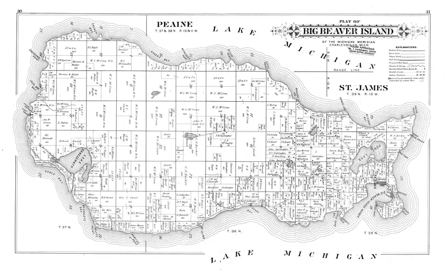
- Beaver Island History Map, 1978 revision · Plat of Big Beaver Island, 1901 · Plat of the north end of Beaver Island, 1930s
Summary
Page Town, commonly written Pagetown in later sources, was a north-end locality between Font Lake and Lake Michigan. A 1901 cadastral plat labels it, and Elizabeth Whitney Williams’s 1905 memoir describes about a dozen houses on the Lake Michigan side of Font Lake. She attributes the name to a Mr. Page who built the first house there with several relatives.
Later Beaver Beacon notices show the name remained in use: a proposed airport was being cleared near Pagetown in 1959, and a 1960 column recommended walking the old road through it. These references establish a locality, not a surveyed boundary; this record therefore has no coordinates or polygon.
The Portage and the History Map
Williams says that from Page Town “the road was good to the portage,” then describes riding by Station Hill with Garden Island visible. That is independent evidence for a north-end place or crossing called the Portage. It does not corroborate the 1978 History Map’s more specific statement that the Portage was the usual winter route to Garden Island.
The same map says a Pagetown store saved boats from rounding the point. No store advertisement, business directory, memoir passage, chart, or contemporary news item found in this review supports that explanation. It remains attributed map testimony rather than part of this article’s factual summary.
Open questions
- Who was the Mr. Page whom Williams names, and do a deed or census schedule identify his household and neighbors?
- Where were the dozen houses relative to the 1901 PAGETOWN label?
- What physical crossing did “the portage” denote, and is there contemporary evidence that winter travelers used it to reach Garden Island?
- Did Pagetown have a store, and what voyage around which point did it avoid?
If you can answer any of these, or correct anything above, the archive wants to hear it — see Corrections.
Maps for this place
These Atlas plates provide regional context. They do not establish a precise boundary, current ownership, access right, operating status, or field condition.
- EnvironmentSoils, wetlands, hydrography, and terrain
- GeologyGeneralized geology and landforms
- HydrologyMapped water and wetland context
- AccessMapped routes, facilities, and protected areas
- Land surveyPLSS geometry and historic GLO patent-location context
Sources
- Described in this archive: Plat of Big Beaver Island, 1901.The contemporary cadastral plat labels PAGETOWN on the east shore south of Indian Point. It establishes the name by 1901 but gives no settlement boundary, store, or explanation of its function.historical_maps · charlevoix_county_plat_book_1901 · big-beaver-island-plat-1901 · big-beaver-island-plat-1901-bitonal
- Described in this archive: A Child of the Sea; and Life among the Mormons, 1905.Williams places Page Town on the Lake Michigan side of Font Lake, recalls about a dozen houses, attributes the name to Mr. Page and his relatives, and says Lake Michigan was less than half a mile from Font Lake. Her nearby statement that “the road was good to the portage” attests a local Portage name but does not say it was the usual winter route to Garden Island.
- Reports tree clearing for Henry C. Allen's proposed airport “in the area known as Pagetown” at the north end, about one mile west of town. It confirms continued local use of the name, not completion of the airport. The holding institution's portal restricts automated access; the archive holds a copy of this issue and can provide it on request.data1 · beaver-island-archive · beaver_beacon · 1959-02_Beaver-Beacon
- Recommends a walk along “the old road through Pagetown and beyond,” independently attesting the locality and old-road association.data1 · beaver-island-archive · beaver_beacon · 1960-10_Beaver-Beacon
- Described in this archive: Beaver Island History Map, 1978 revision.Labels Pagetown and says its store saved boats from rounding the point. The locality is independently attested, but no source located in this review confirms the store or the stated maritime function.
Added 7 August 2026. Recent changes
Cite this article
Beaver Island Archive, “Page Town”, https://beaverislandarchive.org/places/pagetown/, accessed [date], citing P. A. & J. W. Myers, “Plat of Big Beaver Island,” in *Plat Book of Charlevoix County, Michigan* (1901), pp. 30–31. (and 4 further sources listed on the page).
Last revised 2026-08-07. Fill in [date] with the date you read it — this page is static and cannot know that.