

- Dates
- 1930 – 1939
- Eras
- Modern era
- Concepts
- cartographyland-surveypropertyland-usesettlementtoponymytransportation
- Within
- Beaver Island
Summary
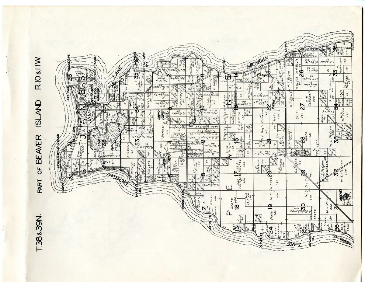
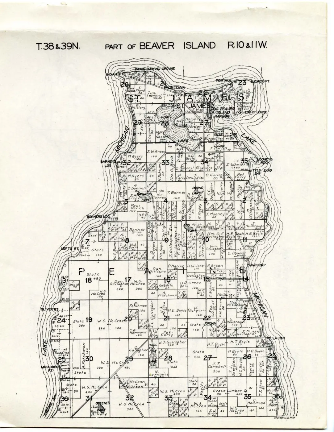
The northern two-thirds of Beaver Island, across both civil townships: from Greene’s Bay and McFadden Point at the foot of the sheet, north through Township of Peaine into Saint James, the harbour, the Portage and Sucker Point. It names the owner and acreage of essentially every parcel, and it is the more crowded of the two island sheets — the settled end of the island, drawn at enough size that forty-acre labels along the east shore are legible.
The southern third is on its counterpart, Plat of the south end of Beaver Island, 1930s.
The sheet
The plat is printed sideways. Its heading runs up the left edge of the leaf, so the sheet has to be turned a quarter-turn clockwise before anything on it reads:
T.38&39N. PART of BEAVER ISLAND R.10&11W.
The two civil townships are named by spacing their letters one to a section:
ST. JAMES across the top of the sheet and PEAINE across its middle. There is
no cartouche, no compass rose, no scale statement and no explanations panel;
Charlevoix Co. Mich. is lettered in a small hand at the foot.
Ownership, as the compilers recorded it
Read what follows as names the county’s records carried when Hixson compiled, as Hixson drew them — not evidence of title, occupancy or residence. This volume, unlike the 1901 one, does not state where its names came from at all.
W. S. McCrea holds the interior here too, in blocks of 520 in section 32,
480 in section 29, 400 in sections 31 and 33, 320 twice in sections 19 and 20,
280 in section 17, and 120 besides — the same name that dominates the southern
sheet and dominated the 1901 plate Plat of Big Beaver Island, 1901.
State holds large inland blocks alongside it, at 480, 280 and 160 acres.
The rest of the sheet is the island’s own surnames, and most of them run straight through from 1901 (spellings verbatim):
- Indian Point to the Portage, along the north shore —
Mrs. E. Landich61.50,Mrs. P. H. O'Donnell56.15,Father Hayes48 and 30.25,T. Floyd40,Tim. Leonard190.25,J. Vincent Est.38,Dunlevy,W. J. Gallagher36.75, andStateon several shore lots. - St. James and the harbour —
R. Millory,Mrs. C. Dowdell48.65,F. Nackerman50.15,T. Leonard80,J. W. Gallagher80,P. Maloney40,C. Gordan76,J. P. Gordy33.50,M. Cull54,E. Burke40,Miller28.65,W. Kerr42.80,J. O'Donnell,H. McCann, and theLIGHT HOUSEon the point. - Font Lake and Barney’s Lake —
M. Ayers120 and 80,J. W. Green160,A. O'Donnell80,M. C. Donnell,J. H. Green,J. Robinson,T. Bonner160,Paul French160,D. P. Boyle40,M. Coffern. - East shore, Looney’s Rock to Little Sand Bay —
J. Martin60,W. Gallagher26.15,M. O'Donnel47.4,D. Boyle73.50,Mrs. O. Boyle120,D. D. Boyle40,D. O'Donnell40,H. Risquers40,J. F. McCauley40,J. Schmidt174.60 and 54.60,P. Early40,J. Deuisdies80,O. Gallagher80,Pat Early58.50,Malloy Bros.80,Malloy62,D. P. Gallagher40,J. F. McDonough80,M. McDonough80,T. McDonough80,F. Chapin40, and aChurchandCem.in section 34. - The centre, Round Lake and Egg Lake to the Jordan —
P. McCauley80,J. C. Gallagher80 and 120,F. McCauley80,N. McCafferty80,H. E. Boyle80,F. Roddy80,A. Gallagher40,J. Riskeders40,H. Gallagher80,M. O'Donnell80,J. Mooney80,Mrs. J. Mooney40,J. Gillispie40,M. Biggs40,O. F. McCauley40,D. Malloy40,P. Gallagher40,Dan Gillispie160,Dan Gallagher320,A. Frotchman,D. R. Green80,A. Green120,D. Wilson110,S. Gallagher,P. Malloy80,W. Richguers160,H. E. Boyle160,P. V. McDonough40,J. Schmidt80,Jos. Schmidt80,T. W. Green80,T. Burke120,W. F. Gill40,T. McCauley40,U. McDonough120,Mrs. L. McDonough,P. McDonough40,W. Resjked40,State160. - South, Greene’s Bay to Point La Par —
A. Fotchman120,W. J. Gallagher120,Banke80,N. Lafinnies80,J. J. Tweddle40,McCann & Green80,Mrs. L. Greinier40,H. T. Boyle,M. Boyle80,M. R. Boyle80,J. J. Campbell200,T. J. Shaw80,Realty Co.80,Grace Lumber Co.200,C. Hammond120,Ross Millory,T. Redding,Smith200,J. S. Gallagher,Sheridan,C. G. McCann, andE. Ranchbeside Fox Lake. - Institutional entries —
Stateon many parcels,Church,Cem.,Sch., theLIGHT HOUSE, andINDIAN BURYING GROUNDlettered on the north shore.
Read the acreages with the hooked mark separated off
As on the southern sheet, a small hooked mark drawn like a figure 6 sits beside a great many parcel labels, and short arrows point from a name into the adjoining parcel. Neither is explained, because this atlas prints no legend. Any figure here that looks larger than the parcel it sits in is that mark read as a digit; the acreages above are given as drawn and a few of them are uncertain for exactly this reason.
No person on this sheet is identified with an article here
An initial and a surname are not an identification on an island carrying this many Gallaghers, Boyles, Greens and McDonoughs, and none of the people articles here holds a land record that could confirm a join. The names are leads.
What is drawn, and what is not
No railway. No cross-tied symbol appears on this sheet, and by the accounts this archive holds the Beaver Island Lumber Company’s narrow-gauge line had been gone since somewhere between 1915 and 1917 — at least thirteen years before the earliest date this atlas can carry.
The line work is roads, drawn as two solid parallel rules, and this is the sheet where the island’s road network can actually be seen. A long straight route runs diagonally north-east from the sections 30/31 corner near McFadden’s Point, past Fox Lake, towards sections 20 and 21, forking in section 29 with a branch running south-east. Others follow section lines through St. James and down the east shore.
The 1901 plate drew a long route on much the same alignment — inland from McFadden’s Point, past Fox Lake, then east — with two dashed casings, a style absent from its own legend, and the earlier article left it unresolved. Here the same alignment is an ordinary road in the ordinary style. That is consistent with the 1901 dashes marking a route then unimproved or projected; it is not evidence for it, because this atlas defines no symbols at all and neither sheet has been georeferenced. See King's Highway.
Names on the sheet
PAGETOWN is lettered on the north shore between Indian Point and the Portage,
as it was in 1901 — a second dated cartographic attestation of
Page Town. INDIAN BURYING GROUND, PORTAGE,
LOONEYS ROCK, BARNEYS LDG. and BONNERS LDG. are likewise lettered and
likewise thinly covered.
Also lettered, matching existing articles: ST. JAMES,
BIG BEAVER ISLAND HARBOR, INDIAN PT., SUCKER PT., LITTLE SAND BAY,
SANDY BAY, LEFTS PT., OLIVER PT., MCFADDENS PT., PT. LA PAR,
GREENES BAY, FONT LAKE, BARNEYS LAKE, ROUND LAKE, EGG LAKE,
FOX LAKE, GREENES lake and JORDAN river.
Open questions
- What the hooked mark means, and how many of the acreages above it has spoiled.
- Whether the diagonal route across sections 31, 29 and 20 is the alignment the 1901 plate drew with dashed casings. Needs georeferencing.
- Whether Pagetown can be tied to a household in a census or a directory of the same decade.
If you can answer any of these, or correct anything above, the archive wants to hear it — see Corrections.
See also
Sources
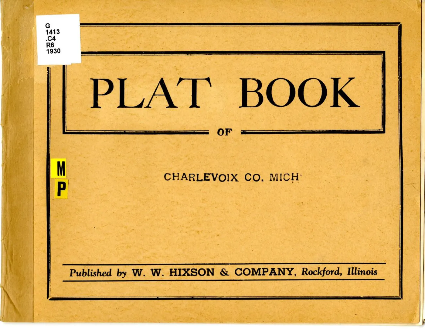
- W. W. Hixson & Company, “T.38 & 39N. Part of Beaver Island R.10 & 11W.”, in
Plat Book of Charlevoix Co. Mich. (Rockford, Ill., between 1930 and 1939).
Read at native resolution from the 6,600 x 5,100 px sheet master held at the
local_pathabove; Michigan State University Digital Repository item 959, ARKark:/85335/m5g73c551. - The volume as a whole, Michigan State University Digital Repository item 946.
kb/articles/documents/big-beaver-island-plat-1901.mdfor the 1901 readings compared above.kb/articles/organizations/beaver-island-lumber-company.mdfor the disputed 1915/1916/1917 end of the island’s narrow-gauge railway.
Read the document
19 pages, rendered from the held scan.

Sources
- Described in this archive: Plat book of Charlevoix County, Michigan, 1930s.The sheet master at 6,600 x 5,100 px, fetched from the holder's own IIIF Image service at the largest size it serves. Canvas 13 of 16 in the atlas manifest and page 15 of the volume PDF; the atlas prints no leaf numbers. The plat is printed sideways on the leaf and has to be turned a quarter-turn to read. Every transcription below was read directly from it at native resolution.historical_maps · charlevoix_county_plat_book_1930s · north-beaver-island-plat-1930s · north-beaver-island-plat-1930s
- Described in this archive: Plat book of Charlevoix County, Michigan, 1930s.Michigan State University Digital Repository item 946. Source for the publication statement, and the evidence that this atlas prints no legend, no scale and no date.historical_maps · charlevoix_county_plat_book_1930s · charlevoix-county-plat-book-1930s
Cite this article
Beaver Island Archive, “Plat of the north end of Beaver Island, 1930s”, https://beaverislandarchive.org/documents/north-beaver-island-plat-1930s/, accessed [date], citing W. W. Hixson & Company, "T.38 & 39N. Part of Beaver Island R.10 & 11W.", in *Plat Book of Charlevoix Co. Mich.* (Rockford, Ill., between 1930 and 1939). (and 1 further source listed on the page).
BibTeX for “Plat of the north end of Beaver Island, 1930s”RIS for “Plat of the north end of Beaver Island, 1930s”