

- Dates
- 1930 – 1939
- Eras
- Modern era
- Concepts
- cartographyland-surveypropertyland-usesettlementtoponymytransportation
- Within
- Beaver Island
Summary
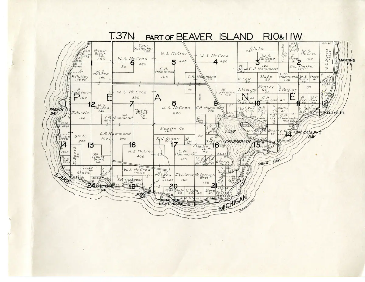
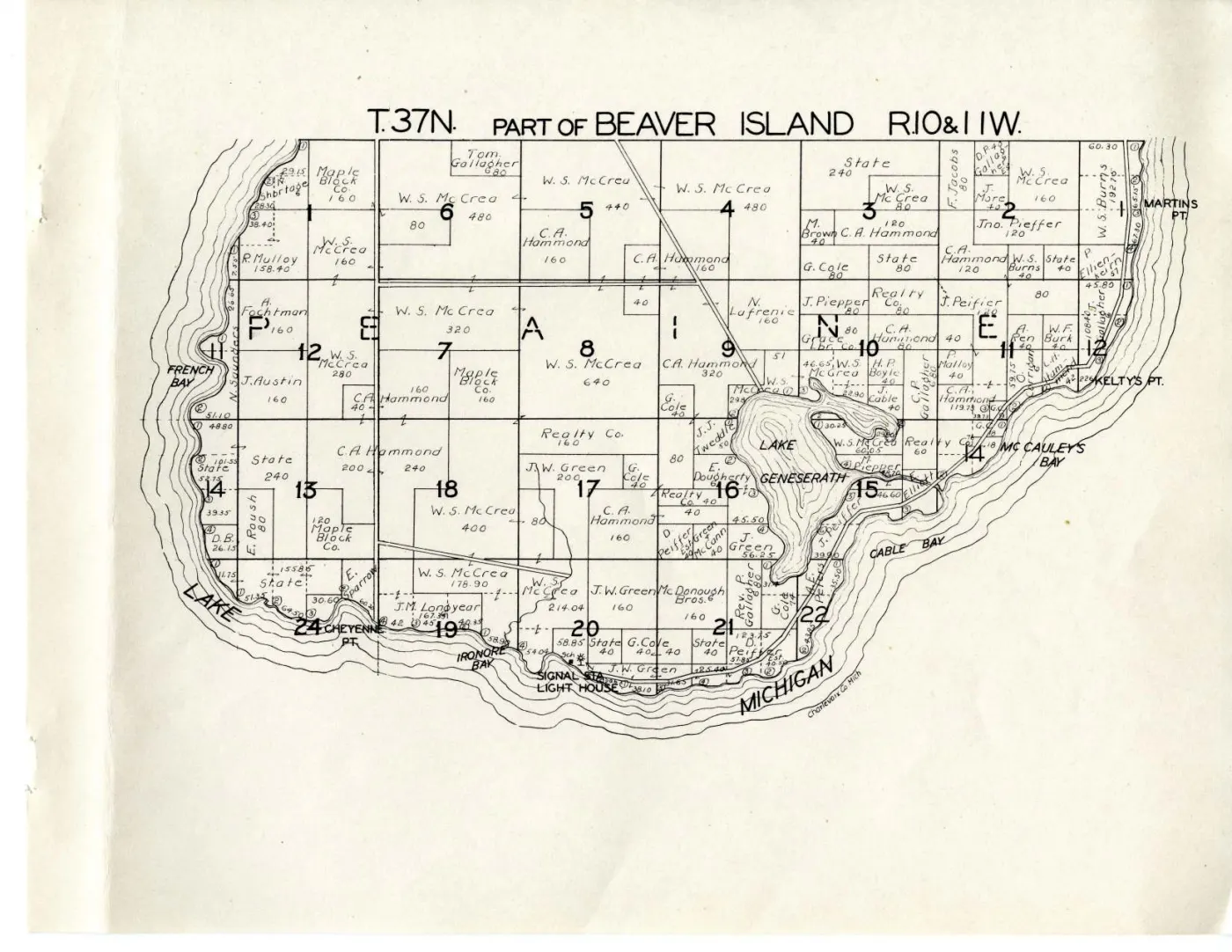
The southern third of Beaver Island — the part of Township of Peaine lying in T.37 N. — drawn to name the owner and the acreage of every parcel from French Bay and Cheyenne Point round by Iron Ore Bay, the light house and the signal station to Cable Bay, McCauley Bay and Martin’s Point, with Lake Geneserath at its centre.
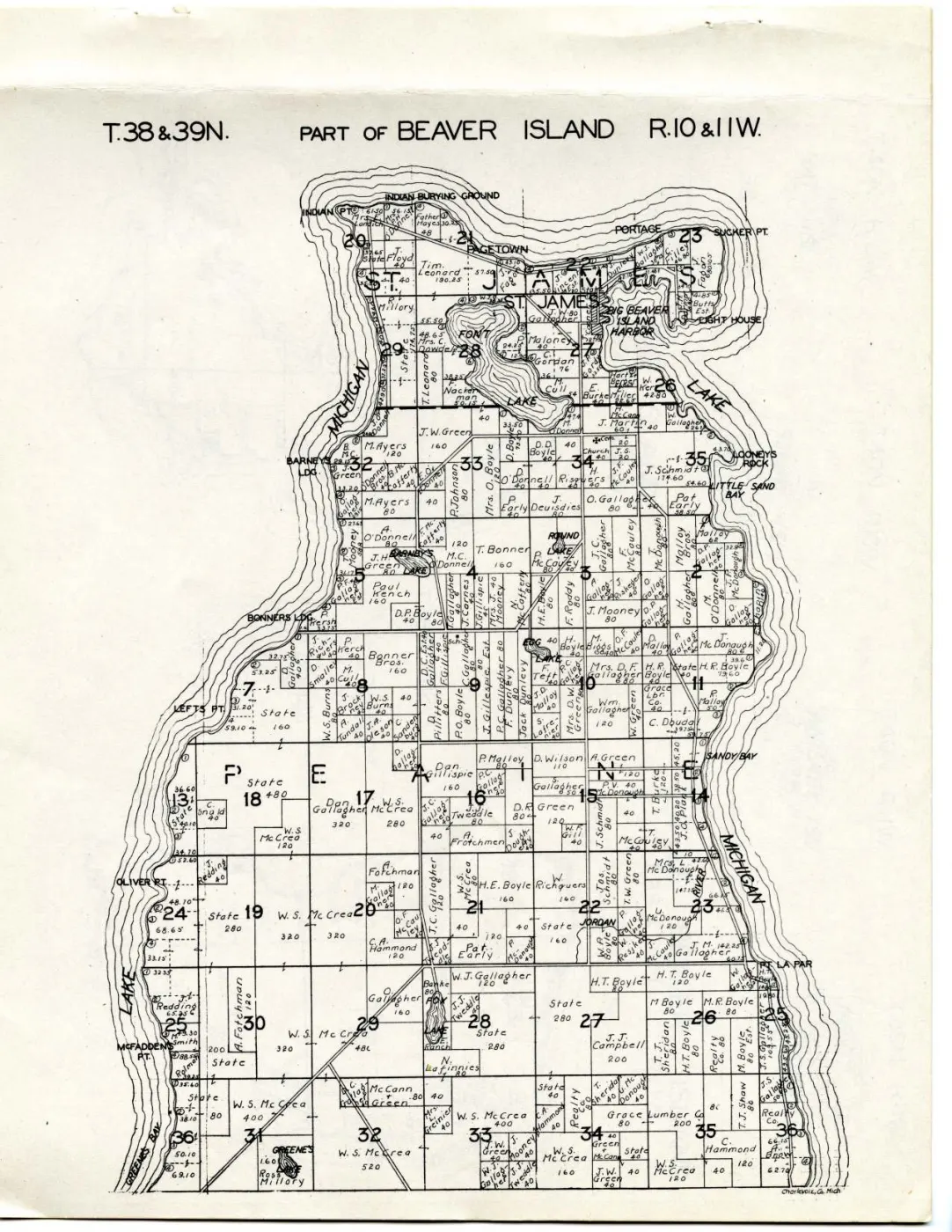
It is the counterpart of the northern sheet Plat of the north end of Beaver Island, 1930s; between them they cover the whole island, which the 1901 edition fitted onto a single double-page spread.
The sheet
The heading is set across the top in plain capitals, with no cartouche and no compass rose:
T.37N. PART OF BEAVER ISLAND R.10&11W.
LAKE MICHIGAN is lettered in the water off the south-west shore and
Charlevoix Co. Mich. in a small hand at the foot. There is no scale
statement, no explanations panel and no date — none of the three appears
anywhere in this atlas.
Section numbers run 1 to 24 across the sheet in heavy figures, and the letters of
PEAINE are set one to a section through the middle of it, which is how the
civil township is named.
Ownership, as the compilers recorded it
Read what follows as names the county’s records carried when Hixson compiled, as Hixson drew them. It is not evidence of title, occupancy or residence — see the volume’s article for why, and note that this volume, unlike the 1901 one, does not even state where its names came from.
W. S. McCrea still dominates the island. The name carries the whole of
section 8 at 640 acres and, around it, blocks of 480 in section 4,
440 in section 5, 400 in section 18, 320 in section 7, 280 in
section 12, 214.04 in section 20 and 178.90 in section 19, with 160- and
80-acre parcels besides. Nothing else on the sheet is close. The same name, on
much the same ground, dominated the 1901 sheet
Plat of Big Beaver Island, 1901 thirty years earlier.
Other holdings, working round the sheet (spellings verbatim):
- North-west, French Bay to the range line —
Maple Block Co.160,R. Mulloy158.40,A. Fochtman160,J. Austin160, and shore lots againstN. Saunders. - North, sections 1 to 6 —
Tom. Gallagher,C. A. Hammond160,State240,F. Jacobs,J. More,Jno. Pieffer120,M. Brown40,W. S. Burt. - Centre, north of Lake Geneserath —
C. A. Hammond320 and 120,G. Cole80 and 40,J. Piepper80,Realty Co.80,N. Lafrenie160,Grace Lbr. Co.,H. P. Boyle40,J. Cable40,C. P. Gallagher,P. Malloy40,J. Tweddle. - West and Iron Ore Bay —
C. A. Hammond200 and 240,Maple Block Co.120,E. Sparrow,J. M. Longyear167.39,State, and theSIGNAL STA.andLIGHT HOUSEon the point with a school symbol beside them. - South and east of the lake —
J. W. Green200 and 160,G. Cole40,Realty Co.160 and 40,E. Dougherty,D. Peiffer Est.40,E. Green & McCann40,J. Green56.25,Rev. P. Gallagher,McDonough Bros.160,M. Piepper48.70,L. Elliott,A. E. Peters,G. Cole74,D. Peiffer57.85. - East shore, McCauley’s Bay to Martin’s Point —
O. Corrigan,C. A. Hammond119.73,A. Fen,W. F. Burk40,W. S. Burt,J. Gallagher,State40,W. S. McCrea160.
State appears far more often, and on far larger inland blocks, than on the
1901 sheet. Tax reversion in the 1920s and 1930s is the obvious explanation and
is only an explanation; nothing held here supports it.
One number on this sheet is not an acreage
A small hooked mark drawn like a figure 6 sits beside a great many parcel
labels — Tom. Gallagher, C. P. Gallagher and Rev. P. Gallagher all carry
it, and reading it as part of the number would give each of them a 680-acre
parcel inside a 640-acre section, which is impossible. Each of those three
parcels is drawn at about 80 acres, and the figure printed beside the mark is 80.
The atlas explains neither the mark nor the short arrows that point from a name into an adjoining parcel. The 1901 volume’s legend defines a hook as connecting lands owned by the same party, which fits — but that is another publisher’s legend and is not evidence about this one. Acreages on this sheet should be read with the mark separated off, and any figure here that looks larger than its section is a misreading of it.
No person on this sheet is identified with an article here
Every plausible match fails the test this archive uses. An initial and a surname are not an identification on an island where a single sheet carries half a dozen distinct Gallagher initials, and none of the people articles carries a land record that could confirm a join. The names above are recorded as leads.
What is drawn, and what is not
No railway appears anywhere on this sheet. There is no cross-tied symbol on it. The Beaver Island Lumber Company was organised in December 1902 and began moving timber by narrow-gauge railway in June 1903; the accounts this archive holds put its end somewhere between 1915 and 1917 and disagree about which, so the railway was gone at least thirteen years before the earliest date this atlas can carry. Its absence here is therefore ordinary — and the 1901 sheet, drawn a year before the company existed, does not show it either.
What is drawn is roads, as two solid parallel rules. One runs the width of the sheet along the section 5/8 line; another cuts diagonally south-east from the north edge to the north-west corner of Lake Geneserath; a third follows the south-east shore from around section 22 north-east past Cable Bay and McCauley’s Bay towards Kelty’s Point, with a branch west along the foot of the lake. All are the same weight and the same style: this atlas prints no legend, so it defines none of them.
Names on the sheet
CABLE BAY — spelled with a C, on the south-east shore between the outlet
end of Lake Geneserath and McCauley’s Bay. The 1901 plate lettered the same water
GABLE BAY. with a G, and Cable Bay carries Gable as a variant. This
is an independent dated attestation of the C spelling, and of the bay’s position,
which has been mis-stated before.
KELTY'S PT. — spelled Kelty, as it was in 1901. Which cape the label denotes
is unresolved: the sheet has not been georeferenced and this archive holds two
nearby capes, Kilty Point and Kelly Point.
Also lettered, all matching existing articles: FRENCH BAY, IRON ORE BAY,
MC CAULEY'S BAY, CHEYENNE PT., MARTINS PT., LAKE GENESERATH,
LAKE MICHIGAN, SIGNAL STA. and LIGHT HOUSE.
Open questions
- Which cape is
KELTY'S PT.? Needs the sheet georeferenced against the GLO plats this archive already holds. - What the hooked mark means.
- Whether the diagonal road across sections 4 and 9 is the same route the 1901 sheet drew with dashed casings. Unresolved without georeferencing.
See also
Sources
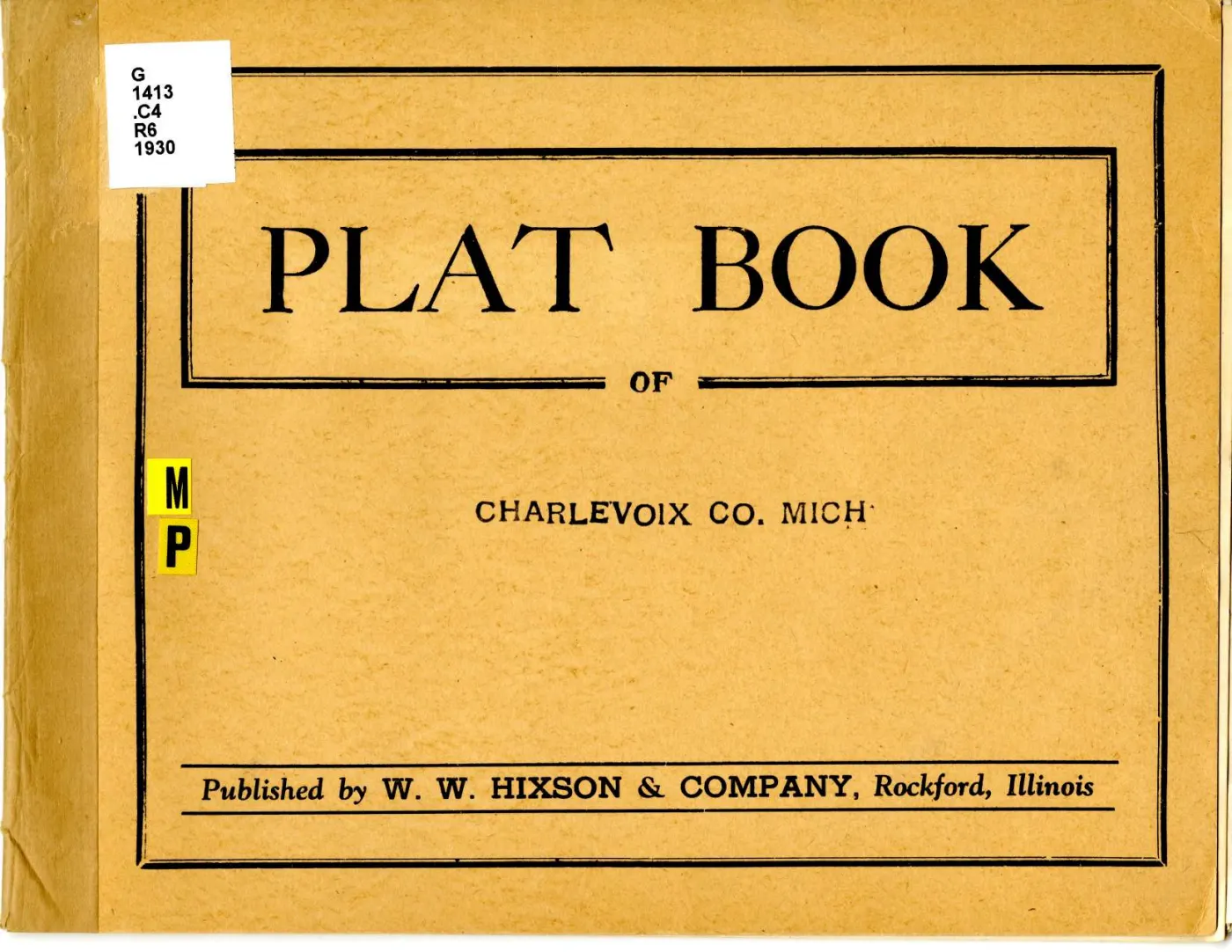
- W. W. Hixson & Company, “T.37N. Part of Beaver Island R.10 & 11W.”, in Plat
Book of Charlevoix Co. Mich. (Rockford, Ill., between 1930 and 1939). Read at
native resolution from the 6,600 x 5,100 px sheet master held at the
local_pathabove; Michigan State University Digital Repository item 958, ARKark:/85335/m5m042z88. - The volume as a whole, Michigan State University Digital Repository item 946: the evidence that this atlas prints no legend, no scale statement and no date.
kb/articles/documents/big-beaver-island-plat-1901.mdfor every 1901 reading compared above.
Read the document
19 pages, rendered from the held scan.

Sources
- Described in this archive: Plat book of Charlevoix County, Michigan, 1930s.The sheet master at 6,600 x 5,100 px, fetched from the holder's own IIIF Image service at the largest size it serves. Canvas 12 of 16 in the atlas manifest and page 14 of the volume PDF; the atlas prints no leaf numbers. Every transcription below was read directly from it at native resolution.historical_maps · charlevoix_county_plat_book_1930s · south-beaver-island-plat-1930s · south-beaver-island-plat-1930s
- Described in this archive: Plat book of Charlevoix County, Michigan, 1930s.Michigan State University Digital Repository item 946. Source for the publication statement, and the evidence that this atlas prints no legend, no scale and no date.historical_maps · charlevoix_county_plat_book_1930s · charlevoix-county-plat-book-1930s
Cite this article
Beaver Island Archive, “Plat of the south end of Beaver Island, 1930s”, https://beaverislandarchive.org/documents/south-beaver-island-plat-1930s/, accessed [date], citing W. W. Hixson & Company, "T.37N. Part of Beaver Island R.10 & 11W.", in *Plat Book of Charlevoix Co. Mich.* (Rockford, Ill., between 1930 and 1939). (and 1 further source listed on the page).
BibTeX for “Plat of the south end of Beaver Island, 1930s”RIS for “Plat of the south end of Beaver Island, 1930s”