

- Along road
- Donegal Bay Road · King's Highway
- Coordinates
- 45.7375° N, 85.5654° WGoogle Maps: Donegal BayDownload KML
- Eras
- Strang eraIrish era
- Concepts
- toponymyStrang eraIrish era
- Within
- Beaver Island
- Media
- Beaver Island History Map, 1978 revision
Summary
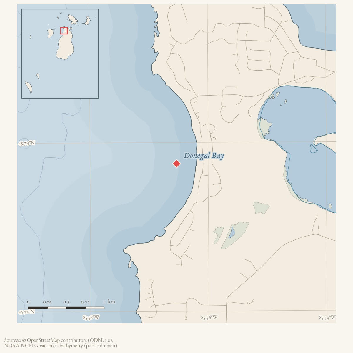
Donegal Bay is a bay on Beaver Island, near Saint James harbor. GNIS records its former name as Mount Pisgah Bay, after the sand dune (“Mount Pisgah”) above the harbor — itself a biblical toponym from James Jesse Strang’s Latter Day Saint settlement (1847–1856). The bay’s current name coincides with County Donegal, Ireland, homeland of the Arranmore-Island emigrants who dominated the island’s population after 1856, though no source documenting the renaming act itself has been located.
History
“Mount Pisgah” — named, like Lake Geneserath and the Jordan River, for a biblical location (Deuteronomy 34:1, where Moses viewed the promised land from Mount Pisgah) — was in use as a place-name at Beaver Island by the early 1850s. A rumor reported to Mackinac authorities held that Strang’s Mormons operated “an artificial cave in Mount Pisgah” for counterfeiting; a search party investigated and found nothing, “conclud[ing] that the cavern was somewhere else.”1 Elizabeth Whitney Williams’ 1905 memoir describes Mount Pisgah as “a high sand mountain,” a short distance from Long Lake, from which “one can look down into the harbor” and see the surrounding islands.2 GNIS records the adjoining bay’s former name as Mount Pisgah Bay, consistent with this same dune. The 1978 Historical Map says that bay-name dated “from Mormon days.” The period association is strong for the hill, but no contemporary source located in this audit uses the full form “Mount Pisgah Bay”; the map’s precise chronological claim therefore remains a retrospective attribution rather than a dated attestation.
The bay’s current name, Donegal Bay, is not explained in any source read so far, but its coincidence with County Donegal, Ireland — the county of origin for Arranmore-Island emigrants who resettled the island after Strang’s 1856 assassination and dominate its subsequent demographic and cultural history — is suggestive. This connection is presented here as a plausible association, not an established fact: no primary or secondary source consulted states directly that the bay was renamed for the county.
Geography
Donegal Bay lies on Beaver Island near Saint James harbor; today’s Beaver Island Master Plan records Donegal Bay Road running along its shore, connecting to Kings Highway and the harbor area, and lists a “Donegal Bay ‘Sunset Beach’” among the island’s recreational sites. The adjacent Mount Pisgah dune area is today partially owned by the Port of St. James Association.
Names
Mount Pisgah Bay → Donegal Bay is a clear example of a Strang-era biblical toponym surviving only as a GNIS variant name rather than in current use — the dune itself is still called “Mount Pisgah” locally and in the 2023 Master Plan, but the bay beside it now carries the modern name. Any historical source using “Mount Pisgah Bay” refers to this same feature.
Significance
The bay’s naming history is a compact illustration of the island’s successive eras: a biblical name from Strang’s theocratic settlement, superseded by (or existing alongside) a name that, if the Donegal association holds, would instead memorialize the Irish community that replaced the Mormon one after 1856.
Open questions
- No source consulted documents when or by whom the bay was renamed from Mount
Pisgah Bay to Donegal Bay, or confirms the connection to County Donegal, Ireland,
as opposed to it being an independent coincidence of naming. This is flagged as
probable/associative, not established. - The relationship between the bay’s name and the still-current “Mount Pisgah” dune name (i.e. why the dune kept its Strang-era name while the bay’s name changed) is not explained in sources held.
- Can a Strang-era chart, deed, newspaper, or letter be found that calls the water feature itself “Mount Pisgah Bay,” rather than calling only the dune Mount Pisgah?
See also
Footnotes
Maps for this place
These Atlas plates provide regional context. They do not establish a precise boundary, current ownership, access right, operating status, or field condition.
- EnvironmentSoils, wetlands, hydrography, and terrain
- GeologyGeneralized geology and landforms
- HydrologyMapped water and wetland context
- AccessMapped routes, facilities, and protected areas
- Land surveyPLSS geometry and historic GLO patent-location context
The dated record
The name, as attested
- Mount Pisgah Bayattested 1853
- Donegal Bay
- 1853
Mount Pisgah Baysuperseded
Strang-era biblical toponym, from the adjacent "Mount Pisgah" dune; Farmer's 1853 Map of the State of Michigan engraves "Mt. Pisgah" (scan held, data/maps/rumsey/farmer_1853_michigan/); GNIS variant record preserves the bay form.
- n.d.
Donegal Baycurrent
Current GNIS name, memorializing County Donegal, origin of the Arranmore emigrants; the specific renaming act is undocumented in sources read so far (see Open questions).
Sources
- GNIS feature 632831; feature class 'Bay'.federal · gnis · gnis_names
- Variant names: Donnegal Bay; Mount Pisgah Bay.federal · gnis · gnis_variant_names
- 'Just a short distance from Long Lake is "Mount Pisgah," a high sand mountain. One can look down into the harbor from its top.' Describes the dune for which the bay's former GNIS name was recorded, and the view of the archipelago from it.
- Recounts an 1850s rumor, reported to Mackinac authorities by a young man taken aboard there, that the Mormons had 'an artificial cave in Mount Pisgah' used for counterfeiting; a search party 'made their way to Mount Pisgah' and found no such cave. Confirms Mount Pisgah as a specific, named hill at Beaver Island in Strang-era usage.
- 'The Mt. Pisgah sand dune area (below) is partially owned by the Port of St. James Association.' Confirms the dune retains the name 'Mount Pisgah' today even though the adjacent bay's GNIS name has moved to 'Donegal Bay.'
- Described in this archive: Beaver Island History Map, 1978 revision.Labels Donegal Bay and says it was Mount Pisgah Bay “from Mormon days.” Contemporary and early sources independently attest Mount Pisgah as the adjacent hill; GNIS preserves Mount Pisgah Bay as a variant. No source located uses the full bay-name during 1847–1856.
Added 28 July 2026 · revised 7 August 2026. Recent changes
Cite this article
Beaver Island Archive, “Donegal Bay”, https://beaverislandarchive.org/places/donegal-bay/, accessed [date], citing U.S. Geological Survey, Geographic Names Information System, Domestic Names (Michigan), retrieved 2026-07-28. (and 5 further sources listed on the page).
Last revised 2026-08-07. Fill in [date] with the date you read it — this page is static and cannot know that.