

- Date
- 1901
- Eras
- Modern era
- Concepts
- cartographyland-surveypropertyland-usesettlementtoponymytransportation
- Within
- Beaver Island
Summary
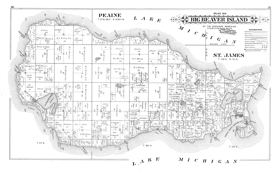
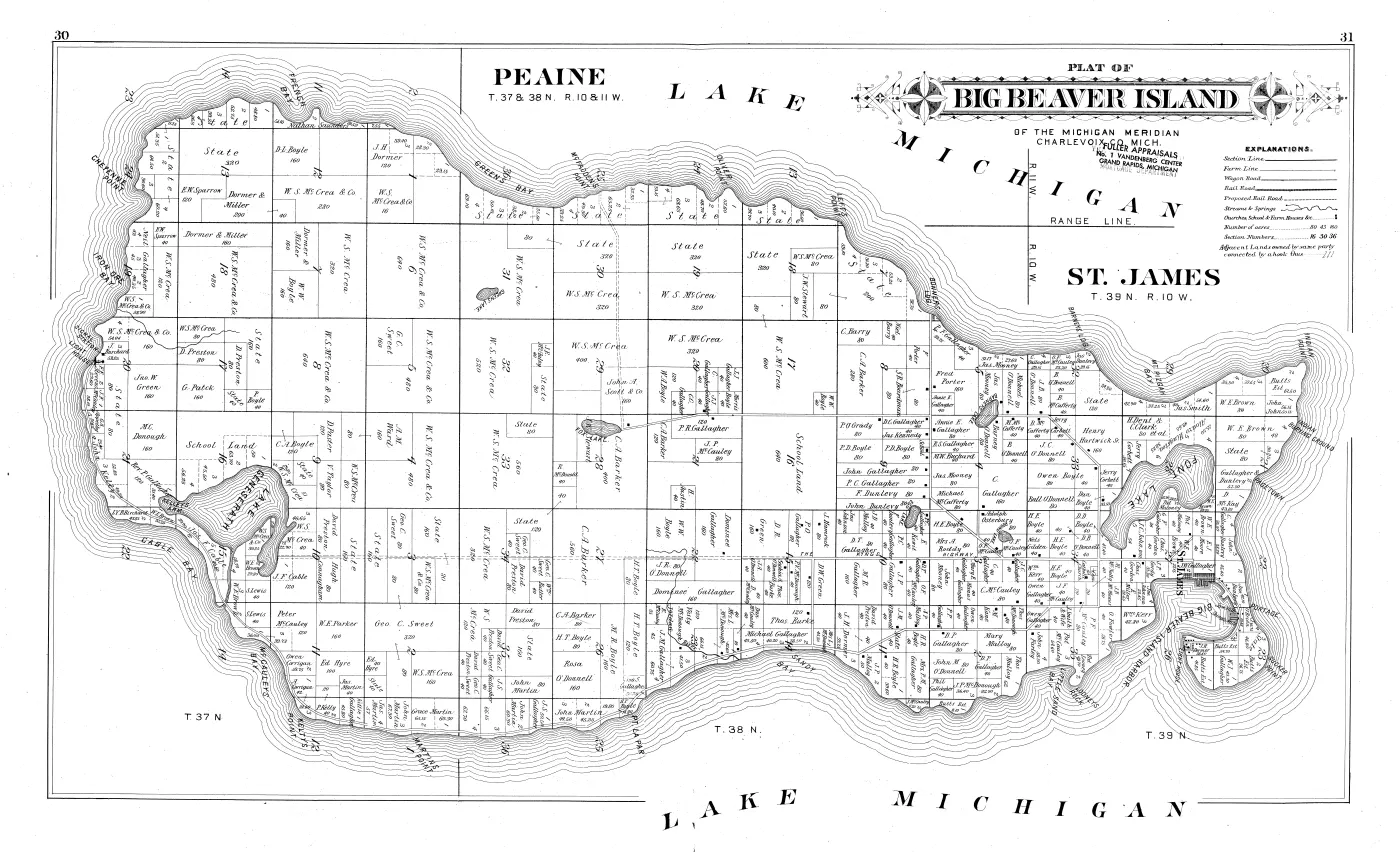
The single most detailed map of Beaver Island’s land ownership the archive holds for the nineteenth or early twentieth century: a double-page spread from the 1901 Myers plat book, naming the owner and acreage of essentially every parcel on the island, from the light station on the south point to the Portage at the north end. Roughly three hundred parcel labels are legible on it.
It is one image in the scan — image 30 of 46 — and two printed pages, folios 30 and 31, whose numbers are engraved in the outer top corners. It is held as a 600 ppi bitonal master at 17,561 × 10,676 px and, separately, as the University of Michigan’s continuous-tone colour scan of the same leaf.
The sheet
The title cartouche sits centre-top of the right-hand leaf, between two compass roses:
PLAT OF BIG BEAVER ISLAND OF THE MICHIGAN MERIDIAN CHARLEVOIX CO. MICH.
with the two civil townships headed separately —
PEAINE — T. 37 & 38 N., R. 10 & 11 W. ST. JAMES — T. 39 N., R. 10 W.
— and RANGE LINE. drawn down the sheet with R. 11 W. and R. 10 W. either
side. LAKE MICHIGAN is set three times in the surrounding water.
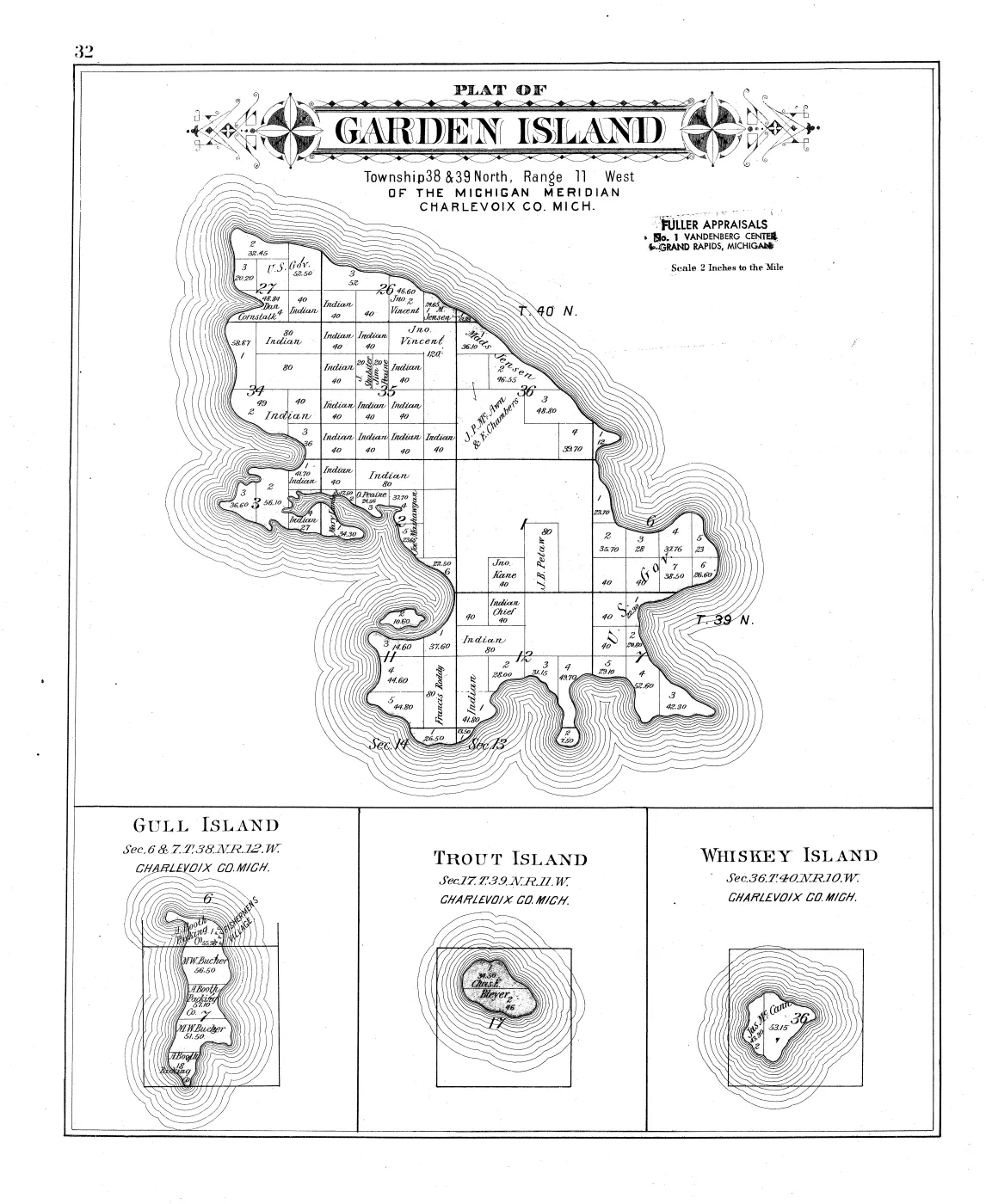
No scale statement is legible on this sheet. The sibling Garden Island plate carries “Scale 2 Inches to the Mile” in the equivalent position; here that position is covered by the stamps described below, so whether one was printed cannot be determined from this copy. The volume’s cataloguing record gives the book’s scale as 1:31,680 — two inches to the mile — for the atlas as a whole.
The explanations panel
Printed at the top right, and the reason this sheet is a transport and settlement document as well as a cadastral one:
EXPLANATIONS. Section Line Farm Line Wagon Road Rail Road Proposed Rail Road Streams & Springs Churches, School & Farm Houses &c. Number of acres … 80 43 160 Section Numbers … 16 30 36 Adjacent Lands owned by same party connected by a hook thus
A wagon road is drawn as two parallel rules; a rail road as a single cross-tied rule; a proposed rail road as a single long-dashed rule; buildings as small filled squares.
What the legend promises and the sheet does not deliver
No built rail road appears anywhere on the island, and the cross-tied symbol occurs nowhere on the sheet. That is consistent with the island’s own history: the Beaver Island Lumber Company was organised in December 1902 and began operating in June 1903, moving timber to St. James by narrow-gauge railway — a year and more after this plate was drawn. A stock publisher’s legend carries the symbol whether or not the county needs it.
Nor is any line confidently identifiable as the “Proposed Rail Road.” A long
route does run from McFadden’s Point south past Fox Lake and then east across
the island, drawn as two parallel dashed rules — which matches neither the
two-solid-rule wagon road nor the single-dashed proposed rail road. East of
about the middle of the sheet the same alignment continues with solid casings
and is labelled THE KINGS HIGHWAY. (spaced capitals; no apostrophe is
engraved). The likeliest reading is one road drawn with dashed casings over its
unimproved western portion, but the sheet does not say so and the style is not
in the legend, so it is recorded here as unresolved rather than resolved the
convenient way. See King's Highway.
Ownership, as the compilers recorded it
Read what follows as names the county’s records carried in 1900–01, as Myers drew them. It is not evidence of title, occupancy or residence — see the volume’s article for why.
One holder dominates the island. W. S. McCrea and W. S. McCrea & Co.
appear on at least thirty separate parcels, including several whole sections
marked 640 acres and further blocks of 600, 560, 520, 480, 400 and repeated
320s, concentrated through the island’s centre and west. No other name on the
sheet is close. The knowledge base contains no article on McCrea and the
string does not occur anywhere in it — a gap this sheet makes conspicuous, and
the most useful research lead it produces.
Other holdings, by area of the island (spellings verbatim):
- North-west, French Bay and Cheyenne Point —
Nathan Saunders,D. L. Boyle160,J. H. Dormer120, and a long run of shore lots markedState. - West and Iron Ore Bay —
E. W. Sparrow,Dormer & Miller(200, 160, 160),Neil Gallagher,J. Burchardbeside theLIGHT HOUSEandSIGNAL STATION,F. L. Stevens,J. H. McCauley,G. A. Appelby. - Centre, around Greene’s Lake and Fox Lake — the McCrea blocks, with
W. W. Boyle,G. C. Sweet,Jno. W. Green160,John A. Scott & Co.160,C. A. Barker(400, 560),D. Preston. - Lake Geneserath, Gable Bay and Kelley’s Arm —
M. C. Donough160,School Land,Rev. P. Gallagher120,Jas. F. CableandJ. F. Cable,W. E. Brown,Geo. C. Sweet,Hugh Connaghan,S. Lewis,L. Y. B. Birchard, and lots held byKelty. - South shore, McCauley’s Bay to Martin’s Point —
Peter McCauley120,W. E. Parker160,Owen Corrigan,A. Corrigan,Ed. Hyre,Kittie Gallagher,P. Kelty, and a family group ofJohn Martin,Grace MartinandJas. Martin. - South-east, the Jordan River to Sandy Bay and Pt. La Par —
H. T. Boyle,M. R. Boyle,Rosa O'Donnell160,Dominee Gallagher160,Vesty McDonough,Thos. Burke,Michael Gallagher,P. R. Gallagher, and a tight cluster of forty-acre parcels held byC. Gallagher,C. C. Gallagher,J. J. Gallagher,J. J. MorrisandGallagher & Boyle. - St. James, from Bonner’s Landing round to the Portage —
C. Barry,S. R. Boardman,Fred Porter160,Jas. Mooney,Annie E. Gallagher,Jas. Kennedy,P. O'Grady, the Dunlevys, the McCaffertys,Jerry Corbett,Henry Hartwick Sr.160,Alonzo Hingston,Pat Maloney,Jas Smith, the Malloys,D. R. GreenandD. W. Green,Wm. Kerr,John Farley,Pat Looney, andButts Est.on five parcels at the head of the island. - Institutional entries —
State,School Land(including the whole of section 16),Catholic Church,Cem.,Saw Mill,Shingle Mill,Light House,Signal StationandSchool.
No person on this sheet is identified with a knowledge-base article
Every plausible match was checked and every one failed the test this project
uses. C. McCauley, Jno. W. Green, W. J. Gallagher, Owen Gallagher,
Dan Boyle and M. Kane each correspond to a KB person of the right surname
who was alive in 1901 — and to nothing more. An initial and a surname are not an
identification on an island where this one sheet carries seven distinct
Gallagher initials across dozens of parcels, and none of those articles contains
a land record that could confirm the join. They are recorded here as leads.
Two cases are worth stating explicitly because they are the ones a later reader is most likely to get wrong:
Jas. F. Cable/J. F. Cableis not evidence that James F. Cable was alive in 1901. James F. Cable carries a death date of 13 July 1896 from Sawyer’s 1911 sketch of his son. A name outliving its owner in a county record is ordinary; the plat cannot resolve it either way. What the plat does add is that a Cable parcel sits on the shore of the bay the sheet spellsGABLE BAY.— see below.Fred Porteris not Feodor Protar. The two men would have been contemporaries in the same part of the island, and the temptation is obvious. The engraving readsFred Porter160 andF. Porter40, unambiguously, at 4.5× magnification. Do not conflate them.
Names on the sheet
The plate is a dated 1901 attestation for two dozen island toponyms. Three are worth calling out.
GABLE BAY. — printed with a G. Cable Bay already records “Gable
Bay” as a variant; this is an independent dated attestation of it, and the sheet
puts a Cable parcel on the adjoining shore. That is suggestive of the
Cable/Gable relation the place article currently leaves open. It is not proof of
it, and the article should not be changed to say otherwise on this evidence.
KELTY'S POINT. — spelled Kelty here, consistently, in three independent
places on the sheet, one of them the landowner P. Kelty. GNIS derives
Kilty Point from Pat Kilty of the 1845 survey crew. Which cape the
plat’s label denotes is unresolved: the archive holds two nearby capes,
Kilty Point and Kelly Point, and the sheet has not been
georeferenced.
PAGETOWN — labelled on the east shore south of Indian Point. This is the
earliest dated attestation currently held for Page Town,
independent of Williams’s 1905 memoir and decades earlier than the 1959
airport-plan notice. KELLEYS ARM., BARNEYS LDG., PORTAGE, LOONEYS ROCK and
INDIAN BURYING GROUND likewise have no articles.
Other labels read off the sheet, all matching existing articles:
FRENCH BAY, GREEN'S BAY, IRON ORE BAY, McCAULEYS BAY, SANDY BAY,
LITTLE SAND BAY, MT. PIZGAH BAY, BIG BEAVER ISLAND HARBOR,
CHEYENNE POINT, McFADDENS POINT, OLIVER POINT, LEFTS POINT,
MARTINS POINT, PT. LA PAR, INDIAN POINT, SUCKER POINT,
LAKE GENESERATH, GREENS LAKE, FOX LAKE., BARNEYS LAKE, FONT LAKE,
EGG LAKE., ROUND LAKE, Jordan River, BONNERS LDG., ST. JAMES.
MT. PIZGAH BAY is spelled that way nowhere else in the archive; whether it is
the water body GNIS records as Mount Pisgah Bay, now Donegal Bay,
needs georeferencing before it is asserted.
Two later stamps
Struck at an angle across the engraved sub-title, in different ink from the plate, and therefore applied long after printing:
FULLER APPRAISALS / No. 1 VANDENBERG CENTER / GRAND RAPIDS, MICHIGAN— dark ink, uppermost. The same stamp appears on the adjacent Garden Island leaf, so it was struck through the bound volume.- Beneath it, fainter and grey-violet:
THE MICHIGAN TRUST CO.…MORTGAGE DEPARTMENT, recovered by isolating the blue channel of the colour scan. The middle of its top line is obscured by the stamp above it and a middle line, if one exists, is unreadable.
Neither firm has been researched. The volume therefore carries a second, later history — a trust company’s mortgage department, then an appraisal firm — which is itself a record of how a county plat book was used, and which the bitonal scan flattens to black.
Open questions
- Who were W. S. McCrea & Co.? The largest landholder on the island in 1901 and absent from this archive entirely. A Chicago or Grand Rapids lumber interest is the obvious hypothesis and is only a hypothesis. The name is still on the same ground thirty years later, holding whole sections on both sheets of the W. W. Hixson edition — see Plat of the south end of Beaver Island, 1930s and Plat of the north end of Beaver Island, 1930s. Two dated attestations of the largest private holding on Beaver Island, and nothing else at all.
- Is the double-dashed route the proposed rail road, or an unimproved wagon road? Settling it needs another county’s sheet from the same publisher, where the same styles can be compared against a legend that is used. The 1930s Hixson edition does not settle it: that atlas prints no legend at all. What it adds is that the same general alignment is drawn there as an ordinary solid-cased road, with no railway symbol anywhere on the island — consistent with a route that was unimproved or projected in 1901, and not evidence for it. See Plat book of Charlevoix County, Michigan, 1930s.
- Which cape is the plat’s
KELTY'S POINT.? Needs the sheet georeferenced against the GLO plats the archive already holds. - Which township does each parcel fall in? The T.38 N./T.39 N. boundary could not be traced on the sheet, so no parcel here is assigned to a township. The GLO plats for T.38 N. R.10 W. and T.39 N. R.10 W. would resolve it.
- Whether a scale statement is printed under the stamps on this leaf.
See also
Sources
- P. A. & J. W. Myers, “Plat of Big Beaver Island of the Michigan Meridian,
Charlevoix Co. Mich.”, in Plat Book of Charlevoix County, Michigan
(Minneapolis: The Consolidated Pub. Co., 1901), printed pp. 30–31. Read at
native resolution from the 600 ppi bitonal master held at the
local_pathabove. - The same leaf in continuous-tone colour, from the University of Michigan’s scanning package — used for the two stamps.
kb/articles/organizations/beaver-island-lumber-company.mdfor the December 1902 organisation and June 1903 start of the island’s narrow-gauge railway.
Read the document
46 pages, rendered from the held scan.













Sources
- Described in this archive: Plat book of Charlevoix County, Michigan, 1901.The 600 ppi bitonal page master, 17,561 x 10,676 px, extracted byte-for-byte from the Internet Archive's Single Page Processed TIFF ZIP. This is image 30 of 46 in the item; it carries printed folios 30 and 31, one in each outer top corner. Every transcription below was read directly from it at native resolution.historical_maps · charlevoix_county_plat_book_1901 · big-beaver-island-plat-1901 · big-beaver-island-plat-1901-bitonal
- Fewer pixels than the bitonal master but it keeps ink colour, and the two rubber stamps on this sheet can only be told apart in it. Used to separate the faint stamp beneath the Fuller Appraisals stamp by isolating the blue channel.historical_maps · charlevoix_county_plat_book_1901 · big-beaver-island-plat-1901 · big-beaver-island-plat-1901-colour
- Internet Archive item 2911302.0001.001.umich.edu, University of Michigan copy. Source for the publication statement and for the image-index / printed-folio table.
Cite this article
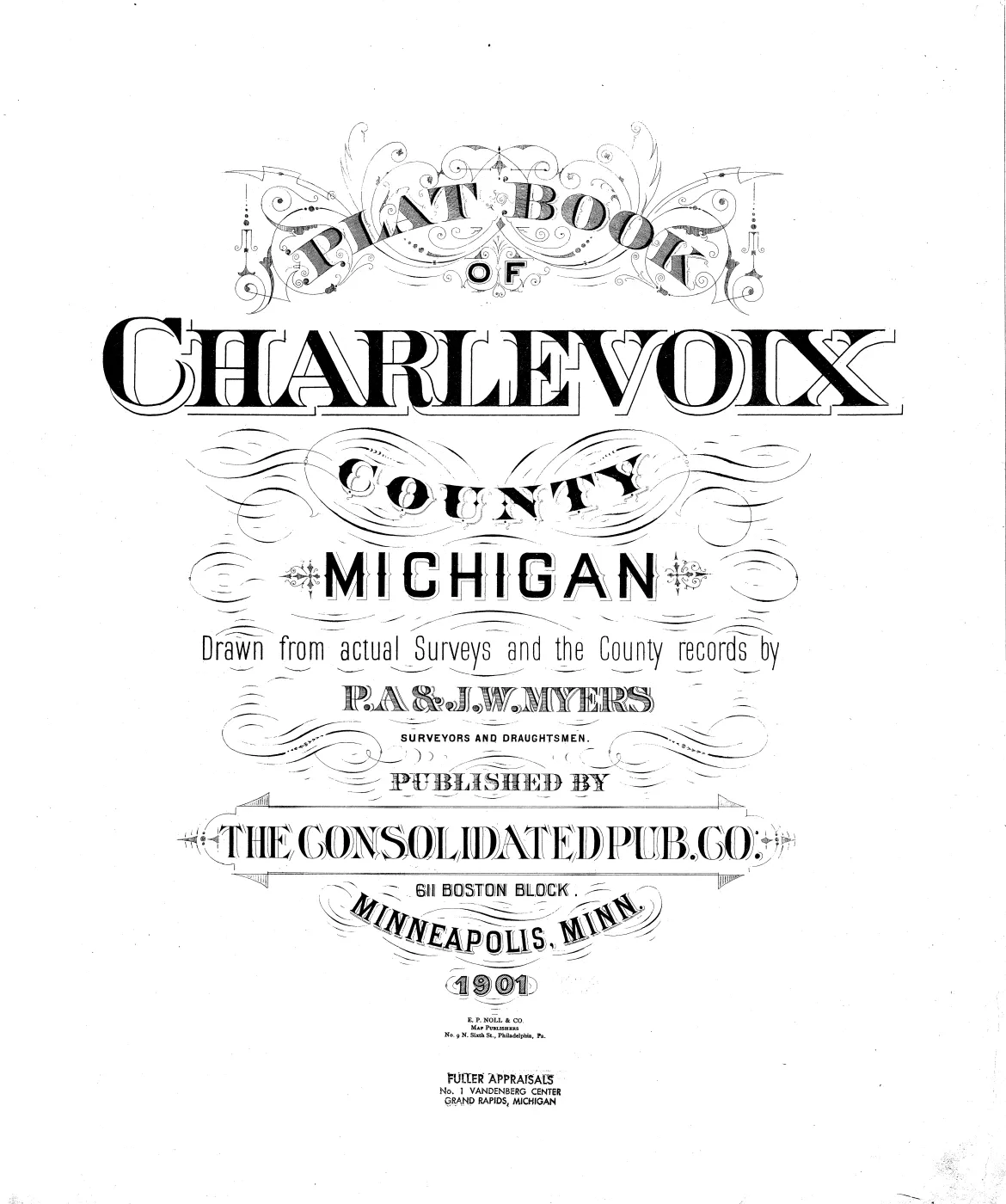
Beaver Island Archive, “Plat of Big Beaver Island, 1901”, https://beaverislandarchive.org/documents/big-beaver-island-plat-1901/, accessed [date], citing P. A. & J. W. Myers, "Plat of Big Beaver Island of the Michigan Meridian, Charlevoix Co. Mich.", in *Plat Book of Charlevoix County, Michigan* (Minneapolis, Minn.: The Consolidated Pub. Co., 1901), printed pp. 30-31 — a double-page spread. (and 2 further sources listed on the page).
BibTeX for “Plat of Big Beaver Island, 1901”RIS for “Plat of Big Beaver Island, 1901”