

- Coordinates
- 45.6096° N, 85.5921° WGoogle Maps: Doty’s Camp TrailDownload KML
- Eras
- Modern era
- Concepts
- trailstransportationrecreationModern eratoponymy
- Within
- Beaver Island
- Media
- Beaver Island History Map, 1978 revision
Summary
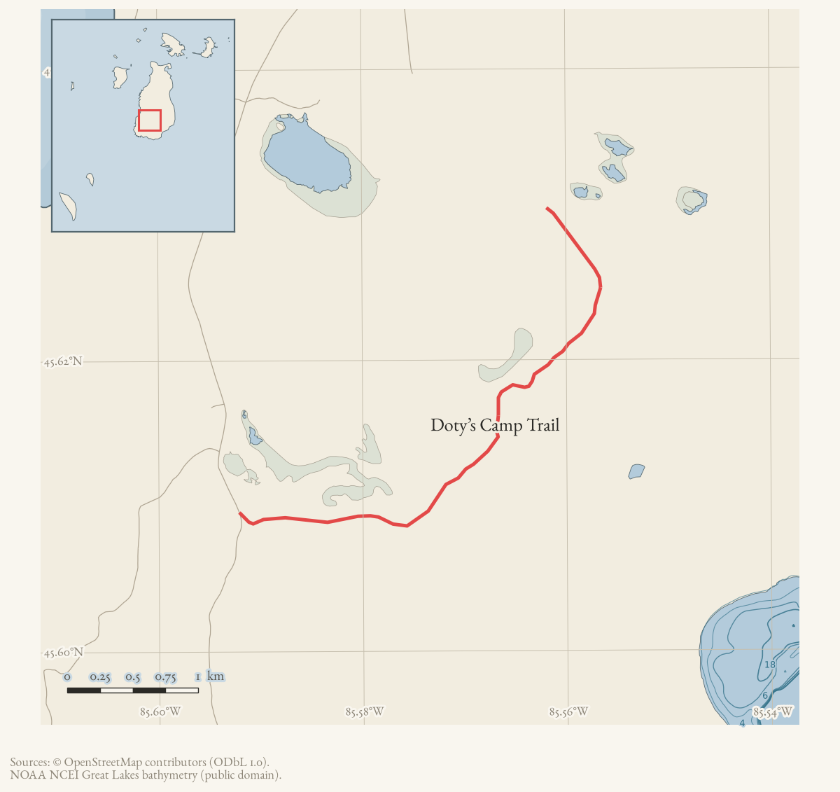
Doty’s Camp Trail is the 2015 map name. Current OSM has several Doty’s Trail segments, so those lines are shown only as an approximate proxy rather than a claim that the names are identical.
A January 1972 Beaver Beacon report independently refers to Doty’s Camp. The 1978 History Map dates the camp to about 1907–1910, but no inspected source corroborates that span; it remains an attributed map claim.
What the trail sheets show
The route runs between two established endpoints on Peaine Township’s own 2021 narrative guide, though the guide’s own passages disagree on the length of the southern leg by nearly a third of a mile.
Coming from the south, the guide’s “Doty’s Camp Trail, south field, Miller’s Marsh” entry says: “South of the Miller’s Marsh parking lot and viewing area 0.2 mile is a two-track to the east… This is Doty’s Camp Trail, and Doty’s Camp is 2.0 miles east on this wide two-track.” A separate “Doty’s Trail” entry in the same guide’s Middle Trails section describes the identical starting point — “Doty’s Trail originates in a field south of Miller’s Marsh at West Side Drive” — and gives the same leg as 1.5 miles to Doty’s Camp. A third passage, describing the route down from the MASH sign, corroborates the shorter figure: from Doty’s Camp, “the rest (left fork) is open and an easy two-track road to the south field at Miller’s Marsh and West Side Drive (1.5 miles).” Two of the guide’s three passages agree on 1.5 miles; the 2.0-mile figure is recorded here rather than silently dropped.
North of the camp the guide is consistent: from Doty’s Camp it is 0.82 to 0.85 mile to “the Y,” where North Lake Trail joins on the township’s account, and the trail continues north to “eventually join/become” Camp #3 Trail, reaching Fox Lake Road/West Side Drive 5.74 miles from the trail’s own Miller’s Marsh origin.
Doty’s Camp itself is described as “clearly a deer camp/drinking area with an outhouse, a huge stone fire pit, plastic chairs and a Weber grill.” The approach from the south is wet enough that “someone has placed many lengthwise logs in it,” and the guide records “several major water holes preventing easy motorized access between Doty’s Camp and Greene’s Lake Road,” while access from West Side Drive is “generally good.”
Access and ownership
No Beaver Island Trail Association cue sheet is dedicated to this trail. The association’s July 2019 North Lake/Buffalo’s Camp sheet only notes, in passing, that walking northwest on Buffalo’s Camp Trail “you will reach the end of the trail where it meets Doty’s Camp Trail” — it does not describe Doty’s Camp Trail’s own route, distances, or land status. The 2024 Peaine Township Parks and Recreation Plan places much of southern Peaine Township — the area this trail crosses, between Miller’s Marsh and Camp #3 Trail — within the Beaver Islands State Wildlife Research Area (Michigan DNR); the archive holds no parcel-level record specific to this trail’s own corridor.
The township’s narrative guide describes the approach to Doty’s Camp as crossing standing water serious enough that someone had laid logs across the trail by hand, and separately notes “several major water holes preventing easy motorized access between Doty’s Camp and Greene’s Lake Road” — evidence of informal, unofficial trail maintenance rather than a managed public facility. No source held here documents a right-of-way instrument for this trail.
There are no designated public ORV trails on Beaver Island (see Trails and trail-making).
As walked in 2019. a walked account contributed in 2019 turns west off West Side Road about a quarter mile south of Miller’s Marsh, with parking available immediately after the turn onto the trail. A public toilet is recorded at Miller’s Marsh, just north of the trailhead.
Evidence and limits
This trail is published: the 2015 map names Doty’s Camp Trail, and the
2021 township narrative describes it in the three separate passages quoted
above. It is mapped only approximately: current OpenStreetMap carries
several “Doty’s Trail” segments, shown here as a proxy rather than a confirmed
match to the printed route, which is why geometry_status is approximate
rather than mapped. No walked GPS track held here is tagged to this trail,
so it is not walked in the archive’s own sense, and no LiDAR or field
search has been recorded against it either.
The same 2019 guide that gives this trail’s approach and parking left its description and distances blank, as it did for Camp 3 Trail — the two trails that share an orange blaze. Both gaps are recorded rather than filled.
Open questions
- Which of the guide’s own conflicting figures for Miller’s Marsh to Doty’s Camp is correct — 2.0 miles or 1.5 miles? Two of the guide’s three passages agree on 1.5 miles; a GPS track of that leg would settle it outright.
- Do the current OpenStreetMap “Doty’s Trail” ways correspond to the printed Doty’s Camp Trail, to a different route, or to both under one name?
- Does the 1978 History Map’s “about 1907–1910” date for Doty’s Camp rest on any source the archive does not hold? No inspected source corroborates it.
- Who was Doty, and when was the camp established? The January 1972 Game Club report places a timber-cutting project near the camp but does not date its founding.
If you can answer any of these, or correct anything above, the archive wants to hear it — see Corrections.
Map status
The displayed line is current OSM data retrieved 2026-08-02 and explicitly qualified as approximate. Pending update: reconcile Doty’s Camp Trail with the 2021 Peaine descriptions and a current field or official map track.
Documented associations
No source-confirmed non-road entity is linked yet. Exact-name research leads remain in scripts/audit_road_links.py; a name collision is not treated as a road association.
Research status
The local newspaper and website corpus contains exact-name mentions in 0 file(s). Those files are research leads; the relation layer is added only when the surrounding source text establishes that the record involves this road.
Maps for this place
These Atlas plates provide regional context. They do not establish a precise boundary, current ownership, access right, operating status, or field condition.
- EnvironmentSoils, wetlands, hydrography, and terrain
- GeologyGeneralized geology and landforms
- HydrologyMapped water and wetland context
- AccessMapped routes, facilities, and protected areas
- Land surveyPLSS geometry and historic GLO patent-location context
Sources
- The legend prints Doty’s Camp Trail.
- Describes Doty’s Trail and Camp #3 connections; it does not establish that every OSM Doty’s Trail segment is the printed Doty’s Camp route.governance · peaine · trails · all-trail-descriptions
- Current named Doty’s Trail ways are shown as an approximate proxy.osm · trails
- Contemporary report places a Game Club timber-cutting project in the vicinity of Doty's Camp, independently establishing the locality by 1972.data1 · beaver-island-archive · beaver_beacon · 1972-01_Beaver-Beacon
- The map supplies the approximate 1907–1910 dates, which were not corroborated by the inspected sources.
- Section 1 places much of southern Peaine Township, which this trail crosses between Miller's Marsh and Camp #3 Trail, within the Beaver Islands State Wildlife Research Area (Michigan DNR); the plan gives no parcel-level boundary for this specific trail.governance · peaine · trails · peaine-park-and-rec-plan-draft-2023-11-27
- Notes in passing that walking northwest on Buffalo's Camp Trail 'you will reach the end of the trail where it meets Doty's Camp Trail'; does not describe Doty's Camp Trail's own route.governance · peaine · trails · bita-north-lake-buffalos-camp-trail-2019-07
- Kamrin, Michael. 'An Insiders Guide to Beaver Island Hiking Trails: A Companion to the Wojan/Cashman Beaver Island Map.' Unpublished typescript, created 8 August 2019, last revised 17 February 2020.Walked account — and a BLANK ENTRY. Gives the approach west off West Side Road about a quarter mile south of Miller's Marsh, with parking right after the turn onto the trail, then leaves both the description and the distances empty. Records the blaze as an orange diamond, shared with Camp 3 Trail, and a public toilet at Miller's Marsh just north of the trailhead.fieldwork · accounts · kamrin-insiders-guide-bi-hiking-trails
Added 2 August 2026 · revised 7 August 2026. Recent changes
Cite this article
Beaver Island Archive, “Doty’s Camp Trail”, https://beaverislandarchive.org/places/dotys-camp-trail/, accessed [date], citing Beaver Island trails map, revised October 2015. (and 7 further sources listed on the page).
Last revised 2026-08-07. Fill in [date] with the date you read it — this page is static and cannot know that.