

- Coordinates
- 45.5956° N, 85.5621° WGoogle Maps: Blue TrailDownload KML
- Eras
- Modern era
- Concepts
- trailstransportationrecreationgeographyheritageModern eratoponymy
- Within
- Beaver Island
- Media
- A blue diamond blaze, 2026
Summary
The Blue Trail — lettered West Lake Trail on the trail association’s own sheets — is a hiking route through the wetlands and low country south of Beaver Island’s settled center. Two extents have to be kept apart. The route as mapped runs from South End Road near the Beaver Head Light north up the west side of Lake Geneserath to the MASH sign. The route as remembered, from a retrospective account of the snowmobile era, ran much further north, from Oil Well #1 down to the light; no map held here draws that longer line. It began as one of several winter routes island snowmobilers marked with paint, and was reopened as a walking path in the early 1980s. From 1990 onward, Boy Scout Troop 200 and Peaine Township’s Trail Committee maintained it through repeated brushing, bridge-building, and gate installation, documented in township minutes and Beaver Beacon reports from 1990 to 2011. The sources agree on its south-end and lighthouse connection but disagree on its length, and no current surveyed line is held.
Official map: Blue Trail / West Lake Trail (BITA, July 2019). It is the source for the printed loop and waypoint distances discussed below, not a current surveyed route.
What the trail sheets show
The 2019 Beaver Island Trail Association sheet places the start “at the intersection of South End Road and Leatherhead’s Road just east of the Beaverhead lighthouse” and states that a complete loop using the Blue Trail, Buffalo’s Camp Trail and East Side Drive/South End Road is 7.5 miles. It also notes a spur joining the Blue Trail to Buffalo’s Camp Trail at its map notation O — the MASH sign — with the instruction to “continue North to link with Doty’s Camp Trail.”
The mapped route follows lettered waypoints printed with coordinates on the 2015 trail map: X → U → R → O, south to north up the lake’s west side, with a V → W spur running east toward Cable’s Bay.
Those letters can be checked against the sheet’s own distance table, because a trail must be at least as long as the straight line between its endpoints. Seven of the eight published legs come out between 1.06× and 1.49× the straight-line distance — exactly what a sinuous footpath does:
| leg | published | straight line | ratio |
|---|---|---|---|
| N → O | 0.60 mi | 0.51 mi | 1.19 |
| O → P | 0.70 mi | 0.66 mi | 1.06 |
| O → R | 1.10 mi | 0.91 mi | 1.21 |
| P → Q | 1.90 mi | 1.56 mi | 1.21 |
| R → U | 0.90 mi | 0.79 mi | 1.14 |
| U → X | 1.60 mi | 1.08 mi | 1.49 |
| V → W | 0.50 mi | 0.41 mi | 1.23 |
| R → V | 0.70 mi | 1.16 mi | 0.60 |
The last line is impossible: no trail between two points is shorter than the straight line between them. Either the sheet’s R→V figure is a misprint or it measures something other than R to V. It is recorded here rather than quietly dropped, and no distance in this article depends on it.
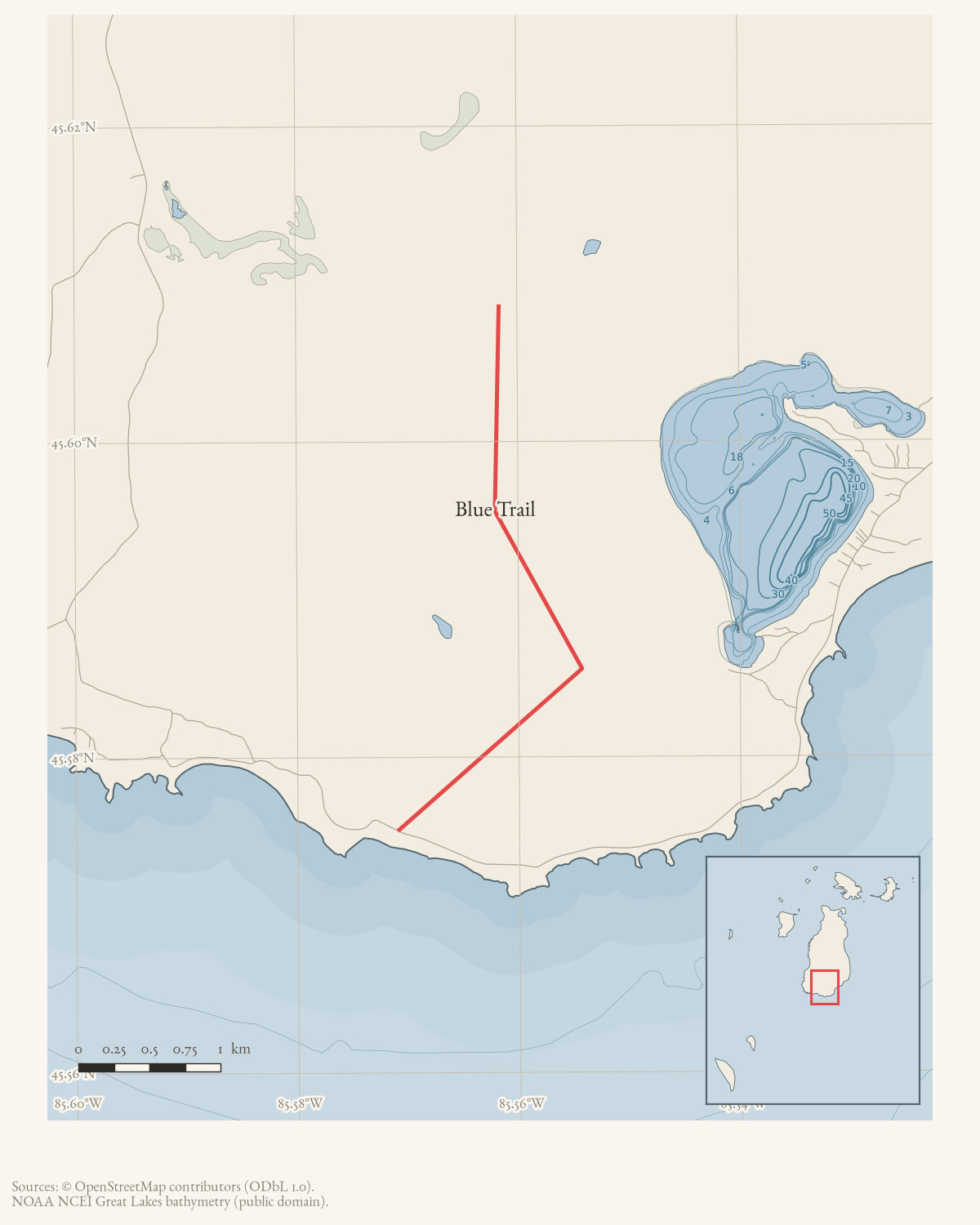
The Blue Trail has no geometry in OpenStreetMap. Checked against the 32 named trails OSM carries for the island on 2026-08-08: neither “Blue Trail” nor “West Lake Trail” appears, though Peaine Township and the trail association both publish sheets for it. The archive’s own walked GPS tracks record 2.61 km of route that passes within 2–8 m of waypoints R and O, and that is currently the only open geometry for it known here.
History
Origins and the 1980s reopening
A Beaver Island Net retrospective account says Bill Wagner, Dick Burris, Walter Wojan, and others opened winter snowmobile routes through the lower third of the island once the machines became available locally, marking them with spray paint; the longest became the Blue Trail, running from Oil Well #1 south to the Beaver Head Light. The trail fell into disuse, then was reopened as a walking path in the early 1980s by children associated with the light, under Audrey Wojan’s guidance, clearing brush and building bridges over wet ground.
Boy Scout Troop 200 and the Trail Committee, 1990-1997
The newspaper record takes up the trail as a subject of organized maintenance in November 1990, when Boy Scout Troop 200 hiked it from Hannigan’s Road to the Bill Wagner Memorial Campground and camped there, practicing basic scouting skills. In April 1991 islander Larry Robinson was reported working on the trail, then described as running roughly fifteen miles from the lighthouse, and the Chamber of Commerce and Peaine Township discussed forming a trail committee; that June the township approved a $500 contribution toward work on the state-land portion. Troop 200 returned in fall 1994, spending a day clearing and marking the trail under Scoutmaster Jim Stambaugh.
By September 1995 Peaine Township’s monthly Trail Committee report recorded that “Blue Trail started,” alongside the newly cleared Kuebler Trail, with signs still to be made and Stambaugh appointed committee co-chairman. An underground fire burned near the trail’s midpoint that October (see Underground fire on the Blue Trail, 1995); a later Beacon retrospective adds that committee member Doug Tilly discovered it after a lightning storm and that volunteers carried gear and water four miles to reach it, detail absent from the contemporary report. By December 1995 the township board had accepted Trail Committee chairman Fred Haubold’s resignation, appointed Stambaugh in his place, approved committee guidelines, installed gates on the Kuebler and Blue Trails, and listed a Blue Trail right-of-way among its 1996 road-work requests.
In 1997 the Trails, Parks, and Campgrounds Committee undertook a wooden walkway through the swamp obstructing the Blue Trail at Johnny Martin’s Trail, aiming for a continuous foot-and-ski route from Hannigan’s Road to Lake Geneserath. That spring, Doug Tilly and Vince Pickhardt also rebuilt the Cable’s Creek footbridge.
A named landmark, and renewed maintenance, 1999-2011
By 1999 Bill Cashman and Jeff Cashman’s guidebook Discovering Beaver Island (Paradise Bay Press, 1999) described “the intense wonderment” of traversing a beaver dam along the Blue Trail, per a Charlevoix Courier review that gave no page number for the passage.
Maintenance continued through the 2000s against repeated beaver interference. In March 2003 Trails Committee member Terry Saxton reported that a six-step, twelve-foot beaver dam had flooded the Wagner Campground Trail’s junction with the Blue Trail, submerging the original markings so thoroughly that his crew had to detour by way of the King’s Highway continuation. Troop 200 marked the trail again under Stambaugh in March 2005, and that December the Trail Committee reported a new hand-built bridge two and a half miles from the road, sturdy enough to bear a four-wheeler, built after the crew found the ground full of wood from earlier beaver-dam bursts.
Eagle Scout projects extended the trail through 2006. One scout offered in April to brush open the section between the Fire Hall and Oil Well #1, and in June twenty scouts camped free at the Wagner Campground for a weekend to build five bridges toward the oil-well site, funded through the township’s Trails Fund. That October, Cory Gratsch reported his troop had rebuilt the connecting trail between the campground and the Blue Trail, work Supervisor John Works praised after inspecting it.
Geography
The sources agree on the south-end and lighthouse connection but not a single measured route: the 1991 report gives roughly fifteen miles from the lighthouse, the 1995 fire report eight miles from King’s Highway’s end to Beaver Head. Accounts also differ on access points – Oil Well #1, the Fire Hall, the Wagner Campground, Johnny Martin’s Trail. The page retains only an approximate northern/start anchor and treats the full route geometry as unresolved.
Map status
The latest held route map is the 2015 printed map; the 2019 BIATA map is an indexed source; neither is current GIS. A January 2025 Peaine Township Planning Commission list names a “Graves Blue Trail” among the township’s trails, alongside Johnny Martin’s Trail; whether this is the historical Blue Trail renamed is not established.
The first walked geometry, 16 August 2026. A traverse out Buffalo’s Camp Trail continued south from the MASH sign — waypoint O — for 2.88 miles to waypoint V, in 97 minutes at a median 2.03 mph. It passed within 1 m of both O and V. That is the first walked line this archive holds for any part of this route, and it replaces two of the straight-line waypoint links on the archive’s trail map.
Two things it does not settle. It touches only the O–V portion: waypoint U lies 739 m off the walked tread, W 532 m, and X — the far end of the published chain — 2,466 m, so most of the route is still carried by nothing but lettered points. And it never comes within 318 m of R, the point the published chain routes through between them, which means the tread and the chain are not the same line even where both exist. The walked line between O and V measures 4,643 m against the chain’s 3,332 m — 39 % longer, which is what a route bending around wet ground does.
geometry_status stays approximate for that reason: one leg is walked, the
rest of the route is not, and the article is about the whole of it.
Access and ownership
Ownership along the route is documented only in pieces. Peaine Township’s June 1991 board minutes recorded a $500 township contribution toward “improving, repairing, and marking the Blue Trail on state land,” with discussion of a matching DNR grant — the clearest ownership statement held here, and it covers only the portion under discussion that year. The southern end, near the Beaver Head Light and the Bill Wagner Memorial Campground, sits in an area the 2024 Peaine Township Parks and Recreation Plan’s asset table lists as leased from the Michigan DNR to the township, and the same plan places the Beaver Islands State Wildlife Research Area over much of southern Peaine Township, which the route crosses.
The township’s own 2021 trail-description guide records that side branches reached from the trail’s southern leg dead-end at locked gates to Applewoods, private land; the guide describes the main trail continuing past them on high ground rather than claiming those branches are open. No source held here documents a public right-of-way instrument for the trail as a whole — the record is township maintenance work and a stated DNR contribution, not a title search.
The 2019 Beaver Island Trail Association sheet for this trail carries the association’s standard disclaimer, current as of that date and not updated since:
“BIATA Trail Maps are not official DNR maps. They were prepared as an imperfect visual guide for the user and should not be relied upon for complete accuracy. Trails can become overgrown and unrecognizable in many areas. Although BIATA has made every reasonable effort to prepare representative maps, users assume the risk of any errors or inaccuracies.”
As walked in 2019. a walked account contributed in 2019 turns north off South End Road just east of the south lighthouse at a trail sign, and cautions that the parking the sign promises 0.2 mile up at the trailhead may be overgrown — it advises parking by the road soon after the turn and walking the 0.2 mile in. It describes the start as heavily grassed and warns that many of the side trails have not been maintained and are ‘extremely difficult to follow’, which matters on a trail whose value is as a way into the wild south half of the island.
Evidence and limits
The Blue Trail is well supported as a named local route and as a recurring subject of Boy Scout and Peaine Township Trail Committee work across two decades of Beacon reports and township minutes. Some reports used here are retrospective “On This Date” columns published years after the events they describe; they corroborate or add detail but are not independent primary accounts. The Beaver Island Net account of the trail’s origins is itself a later retrospective with approximate dates.
Open questions
- Which present-day segments correspond to the historical route between Oil Well #1 and Beaver Head Light?
- Is the 2.88-mile line walked south from the MASH sign on 16 August 2026 the Blue Trail as the township and the trail association understand it? It runs between two of their own lettered waypoints, O and V, but passes 318 m from R, which their chain routes through. No source held here names the walked line itself.
- When was the first Blue Trail route marked, and when did its name become standard?
- Is “Graves Blue Trail,” named in the 2025 Peaine Township capital-improvement list, the same route, a renamed segment, or a different trail?
- Why do the 1991 and 1995 reports give different route lengths (roughly fifteen miles versus eight)?
If you can answer any of these, or correct anything above, the archive wants to hear it — see Corrections.
See also
Documented associations
These source-backed records provide context for the mapped route:
- Underground fire on the Blue Trail, 1995 — On September 10, 1995, an underground fire was reported near the middle of Beaver Island’s Blue Trail. The contemporaneous Beaver Beacon described the Blue walking trail as a multiple-path route from King’s Highway and Hannigan’s Road toward the South End Lighthouse. The report establishes the dated occurrence and its trail context and points to a fresh…
- Peaine Township lists road and access requests for 1996, 1995 — At its November 6, 1995 regular meeting, Peaine Township listed several road and access matters for follow-up in 1996. The Beaver Beacon names Mike Boyle’s Beach turnaround, Cable’s Beach Road, Fox Lake Road, Greenes’ Bay Road, the Blue Trail right-of-way, and Bonner’s Landing; the same report separately records a county contract for Redding’s Trail Road…
Research status
The local newspaper and website corpus contains exact-name mentions in 0 file(s). Those files are research leads; the relation layer is added only when the surrounding source text establishes that the record involves this road.
Correction, 8 August 2026
This article previously carried a point geometry at 45°39’34.8“N, 85°31’37.8”W, the 2015 trail map’s GPS control point C, described as “an approximate northern/start anchor near King’s Highway and Hannigan’s Road.”
Read at full resolution, C sits on the green hatched line the legend calls Hannigan’s Shortcut. No blue line runs within kilometres of it, and the point lies 6.2 km from the solid-blue route the same sheet draws. The anchor had been inferred from the name of a road near the point rather than from the trail’s own symbol — the map was not actually consulted for the thing it was being cited for.
The geometry is now the lettered chain X–U–R–O, which the trail association’s
own distance table uses, and which survives the length check above. It is still
approximate: straight segments between published waypoints are not a surveyed
centreline, and the article says so rather than implying precision it does not
have.
Maps for this place
These Atlas plates provide regional context. They do not establish a precise boundary, current ownership, access right, operating status, or field condition.
- EnvironmentSoils, wetlands, hydrography, and terrain
- GeologyGeneralized geology and landforms
- HydrologyMapped water and wetland context
- AccessMapped routes, facilities, and protected areas
- Land surveyPLSS geometry and historic GLO patent-location context
The dated record
Sources
- The legend includes Blue Trail and separately lists West Lake Trail; the relationship remains source-qualified.
- SUPERSEDED ANCHOR. This citation previously carried the map's control point C (45°39'34.8"N, 85°31'37.8"W) as an approximate northern anchor for the Blue Trail. Read at full resolution, C sits on the green hatched line the legend calls Hannigan's Shortcut, 6.2 km from the solid-blue line the same sheet draws for the Blue Trail; the anchor had been inferred from the nearby road name rather than the trail symbol. The panel is retained as the source for waypoints M-X, which are the Blue Trail's own lettering. Corrected 2026-08-08.
- Indexed map identifies Blue Trail as West Lake Trail and shows a Buffalo’s Camp spur; obtain a current copy or GPS track before asserting geometry. Held locally 2026-08-08. The cited cms5.revize.com address now 404s; the same file is served from peainetwp.org. The sheet states a complete loop using the Blue Trail, Buffalo's Camp Trail and East Side Drive/South End Road is 7.5 miles, and notes a spur linking the Blue Trail to Buffalo's Camp Trail at map notation O (the MASH sign).governance · peaine · trails · bita-blue-trail-2019-07
- Describes early snowmobile routes through the lower third of the island, the Blue Trail from Oil Well #1 to Beaver Head Light, later bridge building, disuse, rerouting, and trail work.
- Describes the Blue walking trail as a multiple-path, eight-mile trail from King’s Highway and Hannigan’s Road to the South End Lighthouse, and records a 1995 underground fire. The holding institution's portal restricts automated access; the archive holds a copy of this issue and can provide it on request.data1 · beaver-island-archive · beaver_beacon · 1995-10_Beaver-Beacon
- The held eighteen-page issue scan is paired with the OCR source and confirms the published notice or report; it does not expand the source-specific identity, event, or outcome claims.data1 · beaver-island-archive · scans · beaver_beacon · issues · 1995-10_Beaver-Beacon
- Reports that Larry Robinson had begun work on the Blue Trail and that a Chamber and township committee planned a trail walk. The holding institution's portal restricts automated access; the archive holds a copy of this issue and can provide it on request.data1 · beaver-island-archive · beaver_beacon · 1991-04_Beaver-Beacon
- The held twenty-two-page issue scan is paired with the OCR source and confirms the published notice or report; it does not expand the source-specific identity, event, or outcome claims.data1 · beaver-island-archive · scans · beaver_beacon · issues · 1991-04_Beaver-Beacon
- Records a $500 contribution for improving, repairing, and marking the Blue Trail on state land, with discussion of DNR grants. The holding institution's portal restricts automated access; the archive holds a copy of this issue and can provide it on request.data1 · beaver-island-archive · beaver_beacon · 1991-06_Beaver-Beacon
- The held twenty-two-page issue scan is paired with the OCR source and confirms the published notice or report; it does not expand the source-specific identity, event, or outcome claims.data1 · beaver-island-archive · scans · beaver_beacon · issues · 1991-06_Beaver-Beacon
- Reports that Boy Scout Troop 200 hiked the Blue Trail from Hannigan's Road to the Bill Wagner Memorial Campground in November 1990, camping and practicing basic scouting skills; the troop had twelve registered scouts at the time. The holding institution's portal restricts automated access; the archive holds a copy of this issue and can provide it on request.
- Reports that Boy Scout Troop 200, under Scoutmaster Jim Stambaugh, spent a day in fall 1994 clearing and marking the Blue Trail. The holding institution's portal restricts automated access; the archive holds a copy of this issue and can provide it on request.
- The Trail Committee report states the Kuebler Trail was cleared, that the Blue Trail 'started,' that signs were still to be made, and that Jim Stambaugh was appointed Trail Committee co-chairman. The holding institution's portal restricts automated access; the archive holds a copy of this issue and can provide it on request.
- Lists a Blue Trail right-of-way among the township's 1996 road-work requests, and separately reports the board accepting Fred Haubold's resignation as Trail Committee chairman, appointing Jim Stambaugh in his place, approving Trail Committee guidelines, and noting gates installed on the Kuebler Trail and the Blue Trail. The holding institution's portal restricts automated access; the archive holds a copy of this issue and can provide it on request.
- Reports the committee's wooden-walkway project through the swamp obstructing the Blue Trail at Johnny Martin's Trail, aimed at a continuous foot-and-ski route from Hannigan's Road to Lake Geneserath, and that Doug Tilly and Vince Pickhardt had rebuilt the Cable's Creek footbridge that spring. The holding institution's portal restricts automated access; the archive holds a copy of this issue and can provide it on request.
- Paul G. Connors, "Discovering Beaver Island" (book review), Charlevoix Courier, 1999.Reviews Bill and Jeff Cashman's guidebook Discovering Beaver Island (Paradise Bay Press, 1999) and quotes its description of traversing a beaver dam along the Blue Trail; the review does not give a page number for the passage, and the guidebook itself is not held. No public copy of this file is known; the archive holds one and can provide it on request.
- Beaver Beacon, March 2003, "News from the Townships," Peaine Township.Reports Trails Committee member Terry Saxton's account that a beaver dam had flooded the Wagner Campground Trail where it meets the Blue Trail, submerging the original trail markings and forcing his crew to detour by way of the King's Highway continuation. No public copy of this file is known; the archive holds one and can provide it on request.
- Beaver Beacon, March 2005, "Beaver Island Scouting."Reports that Scoutmaster Jim Stambaugh's troop of ten scouts spent a day marking the Blue Trail. No public copy of this file is known; the archive holds one and can provide it on request.
- "On This Date," Beaver Beacon, October 2005, Ten Years Ago.Retrospective on the October 1995 underground fire adds that Trail Committee member Doug Tilly discovered it after a lightning storm, ran to Rose Connaghan's house to telephone the fire department, and that volunteers each carried equipment and ten gallons of water four miles to the site; this detail is not in the contemporary 1995 report. No public copy of this file is known; the archive holds one and can provide it on request.
- Beaver Beacon, December 2005, Peaine Township board minutes, Trails Committee report.Reports the Trails Committee's photographs of a new hand-built bridge on the Blue Trail across a stream two and a half miles from the road, strong enough to bear a four-wheeler; the crew found the ground full of wood from earlier beaver-dam bursts. No public copy of this file is known; the archive holds one and can provide it on request.
- Beaver Beacon, April 2006, "News from the Townships," Peaine Township.Reports that an Eagle Scout offered to brush open the section of the Blue Trail from the Fire Hall to the Oil Well Site and build any needed bridges if the township supplied materials. No public copy of this file is known; the archive holds one and can provide it on request.
- Beaver Beacon, June 2006, "News from the Townships," Peaine Township.Reports that twenty Eagle Scouts were to camp free at the Wagner Campground for a weekend and improve the Blue Trail from the campground to the Oil Well Site, building five bridges funded through the township's Trails Fund. No public copy of this file is known; the archive holds one and can provide it on request.
- Beaver Beacon, October 2006, "News from the Townships," Peaine Town Board.Reports a letter from Cory Gratsch stating his Scout Troop had rebuilt the trail between the Bill Wagner Campground and the Blue Trail, and that Supervisor John Works praised the work after inspecting it. No public copy of this file is known; the archive holds one and can provide it on request.
- Beaver Beacon, July 2007, community profile.A profile of an island resident credits her among 'the madwomen who hiked the entire Blue Trail,' incidental evidence the trail was walkable end to end by 2007; the profile does not otherwise describe the trail. No public copy of this file is known; the archive holds one and can provide it on request.
- "On This Date," Beaver Beacon, August 2007, Ten Years Ago.Retrospective on August 1997 corroborates the 1997 Trails, Parks, and Campgrounds Committee report: Doug Tilly and Vince Pickhardt had finished the Cable's Creek bridge, and the next project was a wooden walkway through the swamp crossed by the Blue Trail. No public copy of this file is known; the archive holds one and can provide it on request.
- "On This Date," Beaver Beacon, April 2011, Twenty Years Ago.Retrospective on the April 1991 report confirms that the Chamber of Commerce planned island trail improvements with Larry Robinson, who worked on the Blue Trail; adds no new detail. No public copy of this file is known; the archive holds one and can provide it on request.
- The 2025-2026 capital-improvement priority list names 'Graves Blue Trail' among the township's walking, birding, and waterway trails, alongside Johnny Martin's Trail; whether this is the historical Blue Trail under an updated name is not established.governance · township_meetings · peaine-planning · 01-03-2025-planning-commission-regular-meeting-minutes-approved-c9cdd40cd5
- Trails mapped with a Trimble ProXR GPS in October 2000 and April 2001 over MIRIS basemap data — the earliest instrument survey of these routes the archive holds. Prints twelve waypoints A-L with coordinates; A-L correspond to the 2015 map's M-X for most letters, but CMU J and 2015 V are 498 m apart and are not the same point.governance · peaine · trails · cmu-2008-south-region-1
- Table 3.1 lists the Bill Wagner Campground, near the trail's south end, as MDNR land leased by Peaine Township, and Table 3.4 shows the Beaver Head Lighthouse area under County of Charlevoix and Networks Northwest ownership. Section 1 places much of southern Peaine Township within the Beaver Islands State Wildlife Research Area.governance · peaine · trails · peaine-park-and-rec-plan-draft-2023-11-27
- Printed page 13 describes the trail's southern leg passing a locked gate to Applewoods, private land, and a second branch dead-ending at another Applewoods gate.governance · peaine · trails · all-trail-descriptions
- Kamrin, Michael. 'An Insiders Guide to Beaver Island Hiking Trails: A Companion to the Wojan/Cashman Beaver Island Map.' Unpublished typescript, created 8 August 2019, last revised 17 February 2020.Walked account. Turn north off South End Road just east of the south lighthouse at a trail sign; warns that the parking the sign promises 0.2 mile up at the trailhead 'may be overgrown' and it may be easier to park by the road and walk in. Describes heavy grass at the start, many unmaintained and hard-to-follow side trails, a split about 0.75 mile in where the Blue Trail turns left (north), a loop starting about 1.5 miles in, the Buffalo's Camp Trail junction about 2.25 miles in, and Doty's Camp Trail half a mile beyond that. Blaze: blue diamond, with older blue paint surviving.fieldwork · accounts · kamrin-insiders-guide-bi-hiking-trails
- Walked GPS track, Buffalo's Camp Trail trailhead to waypoint V, 16 August 2026.5.59 miles over 1,904 fixes, 19:05-21:58 UTC, 1.95 mph overall; 4.65 mi at tread pace (median 2.36 mph), 0.44 mi slow, 0.24 mi pushing through cover (median 0.67 mph). Recorded with heart rate. Exported as GPX/CSV/GeoJSON; the original FIT was not supplied, so there is no per-fix accuracy channel and canopy drift cannot be separated from the trail's real meander. Ingested by scripts/ingest_gps_track.py.fieldwork · gps_tracks · beaver-south-2026-08-16-5.59mi
Added 2 August 2026 · revised 20 August 2026. Recent changes
Cite this article
Beaver Island Archive, “Blue Trail”, https://beaverislandarchive.org/places/blue-trail/, accessed [date], citing Beaver Island trails map, revised October 2015. (and 31 further sources listed on the page).
Last revised 2026-08-20. Fill in [date] with the date you read it — this page is static and cannot know that.