

- Coordinates
- 45.6343° N, 85.5475° WGoogle Maps: Johnny Martin’s TrailDownload KML
- Eras
- Modern era
- Concepts
- trailstransportationrecreationModern eratoponymy
- Within
- Beaver Island
- Media
- Beaver Island History Map, 1978 revision
Summary
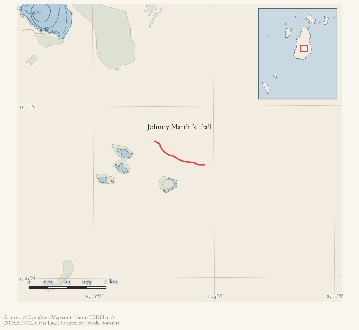
Johnny Martin’s Trail is named in the 2015 map, the Peaine trail-description packet, and current OSM. The map line is the two named OSM segments retrieved 2026-08-02. It is the archive’s clearest example of a lost trail: walkers who tried it in 2017 turned back after losing the markers, a township proposal to reopen the impassable middle section was still awaiting a state permit three years later, and a 2024 visitor report says the same stretch is still flooded by beavers.
Official map: Greene’s Lake / Johnny Martin’s Trail (BITA, July 2019). The sheet’s warning about seasonal wet ground is historical map guidance; the route-condition evidence below is separately dated.
What the route was
The trail runs west from East Side Drive on the county road “Here’s Thuja” through an old gravel pit, then southwest on a smaller two-track through a former beaver pond, where it crosses a large culvert. Past that point the township’s own guide calls it “really wet, with water running down the road much of the year,” and says the trail “theoretically” connects through swampy ground to Middie Perron’s Trail.
Map status
Geometry is mapped from current OSM and simplified for display. Pending update: replace or verify the volunteered line with a current township/DNR track and record the next retrieval date.
History
The middle section has been recorded as impassable for at least a decade. Peaine Township asked the Charlevoix County Road Commission in 2014 to open an impassable roughly 3/4-mile section with three culverts, two gates, and gravel, contracted by the township and pending a Michigan DEQ permit; as of a May 2017 Northern Lake Michigan Islands Collaborative meeting, that permit was still pending. In August 2017 a party attempting the trail reported giving up halfway after losing the trail’s red-dot markers in very wet ground, and a Beaver Island Archipelago Trails Association-linked reply placed reopening it “high on the Beaver Island Archipelago Trail Association’s list, but low on the State’s” priorities. A 2024 forum reply still directs visitors away from the trail, saying beavers keep the meadow flooded past a hand-cleared crossing of the dam.
A July 2019 BITA trail sheet instead describes “the Greene’s Lake Trail, also called Johnny Martin’s Trail” as a 5.5-mile through route from East Side Drive to West Side Drive via Government Tower Trail and Camp 3 Trail — a different shape than the short dead-end route in the township’s narrative guide. See Evidence and limits.
Access and ownership
The trail crosses state land at least in part: the 2014 Road Commission minutes describe it as providing “access to properties” as well as recreational use, and the 2017 collaborative discussion of its culvert involved a Michigan DEQ permit, consistent with regulated wetland or waterway crossing on public or quasi-public ground. No source in the archive gives a complete ownership picture along the route’s full length, and no source establishes a formal public right of way; use is documented through volunteer effort and township road-commission requests, not a recorded easement.
As walked in 2019. a walked account contributed in 2019 turns west off East Side Drive about 1.25 miles south of Hannigan’s Road, on a road with no street sign but a seasonal road sign and Beaver Island Birding Trail marker #16. Parking is at a gravel pit about a third of a mile in; the trailhead is about 0.1 mile beyond, where the road meets the road to the Coyote Land Company. That is the only named landholder on this approach in any source held here, and the archive has nothing else on it.
The account judges the trail beyond the meadow overgrown, uneven and likely underwater in spots early in the season, with downed trees that could make it impassable — and advises reaching Greene’s Lake Trail from its western end instead if that is the point of the walk.
Evidence and limits
Published: named on the 2015 map, in the township’s narrative guide, and
in a 2019 BITA sheet. Walked: only as failed or partial attempts —
the 2017 party that turned back, and 2024 visitors warned off past the beaver
dam; the archive holds no successful end-to-end account. Mapped: two
current OSM ways, simplified for display, geometry_status: mapped, though
these are volunteered geometry rather than a surveyed line and their
correspondence to the ground described above is unconfirmed.
The 2019 BITA sheet’s “Greene’s/Martin’s Trail” and the township guide’s “Johnny Martin’s Trail” may be the same route under two publishing traditions, or two routes that share a family name and pass near each other — see the January 3, 2025 Peaine Township Planning Commission minutes, which keep “Johnny Martin’s Trail” (under trails) and “Buddy Martin’s Trail” (under roads/emergency access) as two separate capital-improvement line items, showing the township itself distinguishes at least two Martin-named routes. Which one the 2017 forum poster and the 2010 “Buddy Martin’s Trail” closure report describe is not established.
Open questions
- Was the 2014 Road Commission culvert-and-gate proposal ever completed? The last dated record (May 2017) still shows the DEQ permit pending.
- Has anyone walked the trail’s full length since the 2017 attempt that turned back, or since the 2024 report of a flooded meadow?
- Is BITA’s “Greene’s Lake Trail, also called Johnny Martin’s Trail” (a 5.5-mile through route to West Side Drive) the same trail as the short, dead-end route the township’s narrative guide describes, or a different route that merely passes nearby?
- Does the “Buddy” in the 2010 forum report of “Buddy Martin’s Trail” being closed by a down tree refer to this trail, to the separate Buddy’s Trail, or to a nickname for someone in the Martin family? The January 2025 township minutes treat “Johnny Martin’s Trail” and “Buddy Martin’s Trail” as distinct capital-improvement items.
If you can answer any of these, or correct anything above, the archive wants to hear it — see Corrections.
See also
Documented associations
No source-confirmed non-road entity is linked yet. Exact-name research leads remain in scripts/audit_road_links.py; a name collision is not treated as a road association.
Research status
The local newspaper and website corpus contains exact-name mentions in 0 file(s). Those files are research leads; the relation layer is added only when the surrounding source text establishes that the record involves this road.
Maps for this place
These Atlas plates provide regional context. They do not establish a precise boundary, current ownership, access right, operating status, or field condition.
- EnvironmentSoils, wetlands, hydrography, and terrain
- GeologyGeneralized geology and landforms
- HydrologyMapped water and wetland context
- AccessMapped routes, facilities, and protected areas
- Land surveyPLSS geometry and historic GLO patent-location context
The dated record
Sources
- The legend prints Johnny Martin’s Trail.
- Page 4 says the trail runs west from East Side Drive on the county road 'Here's Thuja' through an old gravel pit, crosses a large culvert at a former beaver pond, and 'is really wet, with water running down the road much of the year.' It says the trail 'theoretically' connects through swampy ground to Middie Perron's Trail and that, as of 2019, 'about 0.5 mile is pretty impassable' with many downed trees. Older than the current OSM snapshot.governance · peaine · trails · all-trail-descriptions
- Two current named OSM ways (265420265 and 265420266), simplified for display; volunteered geometry is not a surveyed boundary.osm · trails
- A forum notice reported that a trail called "Martin's Trail" was closed because of a down tree. The archived post does not establish whether its "Buddy" wording refers to the currently documented Johnny Martin's Trail, nor when the obstruction was cleared; this is retained as a qualified historical maintenance report, not as proof of route identity or a current closure.forum · www.beaverislandforum.com · 02 · t002576
- Names this route 'the Greene's Lake Trail, also called Johnny Martin's Trail,' running from East Side Drive about a mile south of Wagner Campground through Government Tower Trail, across Camp 3 Trail, past Greene's Lake, and ending at West Side Drive -- a 5.5-mile through route. That does not match the shorter dead-end description in the township's own narrative guide, which has Johnny Martin's Trail running west from Here's Thuja to an impassable swamp. Whether BITA's sheet names the same trail under a broadened definition, or a different route that merely passes near it, is not established here. Carries BIATA's standing disclaimer that its maps are not official DNR maps.governance · peaine · trails · bita-greenes-martin-trail-2019-07
- Charlevoix County Road Commission, 2014 Regular Board Minutes.Records a Peaine Township request to open an impassable approximate 3/4-mile section of 'Johnny Martin Trail' -- described as providing access to properties and used for recreation -- by installing three 24-inch by 20-foot culverts, two gates, and about 200 yards of gravel, contracted by the township pending a DEQ permit. The improvement was designed for ATVs only, not large vehicles.governance · township_meetings · charlevoix-road-commission · 2014-regular-board-minutes-a8c1cfdb64
- Northern Lake Michigan Islands Collaborative, meeting notes, 4 May 2017.Records the question 'Pam asked about the culvert on Johnny Martin's? Where are we?' answered 'it's with the DEQ at the moment' -- showing the 2014 culvert proposal was still awaiting permit three years later.governance · township_meetings · nlmi-collaborative · may-4-2017-meeting-notes-6a6b18da81
- A reply on the same thread, subject 'Johnny Martin trail,' 25 August 2017: 'We attempted the Johnny Martin trail yesterday and it was VERY wet. We gave up halfway after we lost the red dot markers. It would be great to have a cross island trail. Any plans to fix it?' A BIATA-linked poster replied that reopening it was 'high on the Beaver Island Archipelago Trail Association's list, but low on the State's right now.' Participant testimony, not a survey or maintenance record.forum · www.beaverislandforum.com · 12 · t012153
- Beaver Island Forum, "First Time Tent Camping," July 2024.A local reply directing a visitor away from the trail: 'It is not far from Johnny Martin's Trail, but I don't recommend that. The beavers have the meadow flooded. We cleared a path across the beaver dam, but beyond that is still very wet.' Confirms the beaver-flooded, impassable condition persisted at least into 2024.forum · www.beaverislandforum.com · 18 · t018225
- Peaine Township Planning Commission, regular meeting minutes, 3 January 2025.The 2025-2026 Capital Improvement Plan priority list keeps 'Johnny Martin's Trail' under item (e), All Trails, distinct from a separate item (b), Roads - Emergency Road Access, Buddy Martin's Trail -- township evidence that these are two different named routes despite the shared surname.governance · township_meetings · peaine-planning · 01-03-2025-planning-commission-regular-meeting-minutes-approved-c9cdd40cd5
- Kamrin, Michael. 'An Insiders Guide to Beaver Island Hiking Trails: A Companion to the Wojan/Cashman Beaver Island Map.' Unpublished typescript, created 8 August 2019, last revised 17 February 2020.Walked account covering Johnny Martin's and Greene's Lake as one route. Turn west off East Side Drive about 1.25 miles south of Hannigan's Road on Johnny Martin's road, which has no street sign but carries a seasonal road sign and Birding Trail marker #16; parking at a gravel pit about a third of a mile in, trailhead about 0.1 mile further where the road meets the road to the Coyote Land Company. Beyond a small meadow with a large culvert the trail is overgrown and uneven, still damp in late August, with downed trees across it. About 2.7 miles from the trailhead to Middie Perron's Trail. Blaze: red paint on trees.fieldwork · accounts · kamrin-insiders-guide-bi-hiking-trails
Added 2 August 2026. Recent changes
Cite this article
Beaver Island Archive, “Johnny Martin’s Trail”, https://beaverislandarchive.org/places/johnny-martins-trail/, accessed [date], citing Beaver Island trails map, revised October 2015. (and 10 further sources listed on the page).
Last revised 2026-08-02. Fill in [date] with the date you read it — this page is static and cannot know that.
BibTeX for “Johnny Martin’s Trail”RIS for “Johnny Martin’s Trail”