

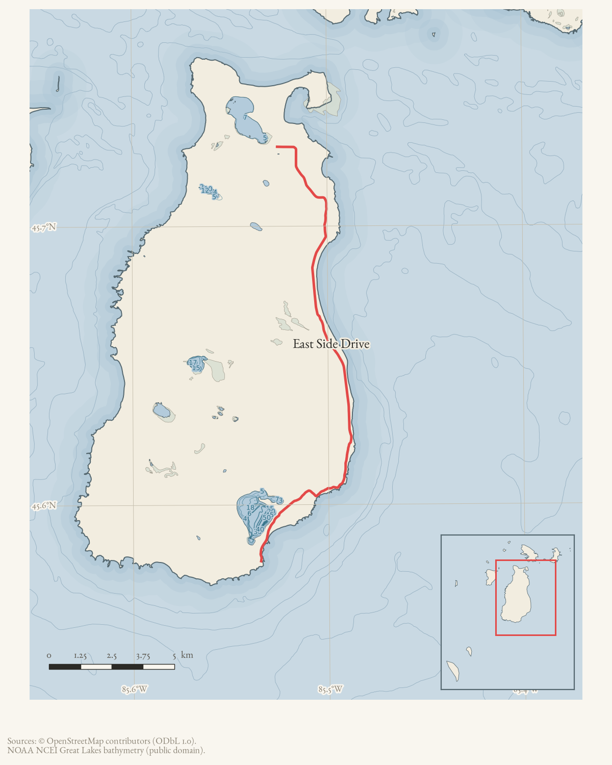
- Intersects
- Barneys Lake Road North · Cable's Creek Road · CMU Biological Station Access · CMU Biological Station Campground Access · Fishing Site Road · Grant's Road · Hannigan's Road · Hemlock Point Road · Jewell Road · King's Highway · Little Sand Bay Nature Preserve Access · Melody Lane + 8 more
- Coordinates
- 45.6581° N, 85.4994° WGoogle Maps: East Side DriveDownload KML
- Eras
- Modern era
- Concepts
- transportationtoponymy
- Within
- Beaver Island archipelago
- Media
- General highway map of Charlevoix County, 1965
Summary
East Side Drive runs along the eastern shore of Beaver Island, from south of Lake Geneserath north to
Welke Airport and beyond. The two current OpenStreetMap ways carrying the
name are merged here into one route geometry of about 20.5 km, and the road
meets 20 other named roads along its length (listed under
intersects_road). Newspaper notices from the 1960s to the present place
homes, farms, a subdivision, an airport, a public boat launch, and a state
wildlife-research area along it, making it one of the island’s principal
residential and recreational corridors on the east side.
History
The road appears in the record from at least 1961, when property notices placed new lot purchases in Wicklow Beach, a subdivision on the road: Dr. Philip F. Lange of Lansing bought two lots there that February,1 and ten Girl Scouts and three leaders from Lansing Troop 361 camped that June at the State Forest Camp Grounds on East Side Drive.2 The following year brought both incident and observation: an April 1962 report on plans to bring ringneck pheasants to the island also recorded sightings along the road,3 a February snow emergency made the access road to the Willie Schmidt Farm impassable,4 and a July 1962 report described a serious vehicle accident on the road in which Vera Lewis was injured and later hospitalized at Charlevoix.5
The 1970s record several residential milestones. A September 1972 notice welcomed new and newly permanent residents, including the David Gladish family, who purchased the Johnson cottage on East Side Drive;6 the same year, Robert A. McGlocklin composed a collective letter from island businessmen to Governor William G. Milliken protesting property-tax increases.7 In February 1974 a birth notice for Matthew Patrick Carey connected the family to the Willie Schmidt farm on the road.8 A 1986 building-permit notice recorded Bernard Esch’s planned new residence at the end of Grant’s Road, off East Side Drive, in Peaine Township.9
More recent records describe the road’s continued residential and recreational use and its maintenance as a county route. A December 2024 profile of the Pebble Beach subdivision recounts Bill Turner acquiring a lot on East Side Drive, where the Turner family built the locally known “house on the hill,” a Sears kit house that the profile says still stands.10 In 2026 the road appears twice in local governance records: a May resolution by the Peaine Township Board asked the Charlevoix County Road Commission for a traffic-engineering and safety speed study naming East Side Drive among other roads,11 and a June road-work bulletin reported intermittent East Side Drive closures near Welke Airport as part of wider county road-commission work.12
Geography
East Side Drive follows the island’s eastern shoreline, connecting Lake Geneserath Public Access at the south end to Welke Airport farther north, with Wicklow Beach and the Pebble Beach subdivision among the shoreline communities it serves.131410 It also runs near Martins Bluff and Little Sand Bay, and a 2003 legal description for a Peaine Township tract follows the road’s south line as a boundary.15 Land along the corridor also falls partly within the Beaver Islands State Wildlife Research Area.16
Names
The current name is what OpenStreetMap volunteers have mapped; no older spelling or a road-commission record establishing when the name was adopted has been located.
Significance
East Side Drive is the principal road serving Beaver Island’s eastern shoreline residential and recreational sites — camps, cottages, farms, a subdivision, an airport, and a public lake access — and its county maintenance and safety records show it remains an active, actively maintained route into the present.
Open questions
- When was the name “East Side Drive” adopted, and what did the road’s earlier road-commission or plat records call it?
- What is the road’s full length, right-of-way status, and maintaining authority under county records, as distinct from the current volunteered OpenStreetMap mapping?
- Did Bernard Esch’s 1986 residence at the end of Grant’s Road, or the Gladish family’s 1972 purchase of the Johnson cottage, leave any further documented history?
- What was the outcome of the Peaine Township Board’s 2026 request for a traffic-engineering and safety speed study of the road?
See also
Documented associations
These source-backed records provide context for the mapped route:
- New permanent residents reported on Beaver Island, 1972 — The September 1972 Beaver Beacon welcomed Phyllis Townsend, Vivian Visscher, and the David Gladish family as new or newly permanent Beaver Island residents. It said Townsend moved after retiring, Visscher became a year-round resident, and the Gladishes purchased the Johnson cottage on East Side Drive; their son Andrew was attending the Community School.
- Beaver Island residents report ringneck pheasant sightings, 1962 — The April 1962 Beaver Beacon reported that Bruce Meixsell planned to bring ringneck pheasants to Beaver Island and described sightings by Ralph Rutt, Gabriel M. Campbell, and visitors along East Side Drive.
- Beaver Island road-work and runway-access bulletin, 2026 — On June 3, 2026, WVBI summarized several Charlevoix County Road Commission activities and notices on Beaver Island. The bulletin reported chloride work on Barney’s Lake Road and Allen’s Lakeview Drive, upcoming paving on Freesoil Avenue and Maple Street, intermittent East Side Drive closures near Welke Airport, and a restriction on using Hangar Road…
- Two vehicle accidents are reported near Beaver Island, 1962 — The July 1962 Beaver Beacon reports two vehicle accidents. Patrick Gallagher’s truck struck a tree near the airport; passenger Ben O’Donnell was treated at the Medical Center. In a separate East Side Drive crash, Vera Lewis was seriously injured and later hospitalized at Charlevoix.
- Birth of Matthew Patrick Carey, 1974 — Matthew Patrick Carey was announced as born on February 3, 1974, to Dr. and Mrs. Charles Carey of Ann Arbor. The notice gives his weight as 8 lb. 3 oz. and connects the family to the Willie Schmidt farm on Beaver Island’s East Side Drive.
- Residence permitted at the end of Grant’s Road, 1986 — A 1986 Charlevoix Courier building-permit notice listed Bernard Esch to construct a new residence at the end of Grant’s Road, off East Side Drive, in Peaine Township. The notice establishes a planned residence and its approximate road setting, but not a street number, exact parcel, builder relationship, or proof of completion.
- Lansing Girl Scout troop camps at Beaver Island State Forest grounds, 1961 — Ten Girl Scouts and three leaders from Lansing Troop 361 camped at Beaver Island’s State Forest Camp Grounds on East Side Drive during the second week of June 1961.
- Peaine Township traffic-engineering and safety study request, 2026 — On May 19, 2026, the Peaine Township Board adopted Resolution 14-2026, requesting that the Charlevoix County Road Commission initiate a traffic- engineering and safety speed study. The resolution names East Side Drive, Donnel Mor’s Lane, Paid Een Og’s Road, and Tom McCauley Road and asks that the study account for seasonal traffic, pedestrians and…
- Philip F. Lange purchases two Wicklow Beach lots, 1961 — The February issue reports that Dr. Philip F. Lange of Lansing purchased two lots in Wicklow Beach on East Side Drive.
- Charles Carey — Dr. Charles Carey was named as the father of Matthew Patrick Carey in a February 1974 birth notice. The same notice says the Carey family owned the Willie Schmidt farm on Beaver Island’s East Side Drive.
- Dr. Philip F. Lange — Dr. Philip F. Lange (1925–2009) of Lansing is identified in the February 1961 issue as the purchaser of two Wicklow Beach lots on East Side Drive.
- Robert A. McGlocklin — Robert A. McGlocklin is identified in the April 1972 Beaver Beacon as the composer of a letter signed collectively by Beaver Island businessmen and sent to Governor William G. Milliken about property-tax increases.
- Beaver Islands State Wildlife Research Area — Beaver Islands State Wildlife Research Area is a Michigan Department of Natural Resources public-land designation covering substantial state-managed land in the Beaver Island archipelago, dating from the 1970s. Local reporting places 9,195.5 acres of the Beaver Island portion within the 2024…
- Lake Geneserath Public Access — Lake Geneserath Public Access is a public boat-launch and recreation site listed in the Beaver Island recreation-facilities inventory. The inventory places it off East Side Drive at the south end of the island and describes an outhouse and trail as well as the lake access. A later DNR–Peaine lease names Lake Geneserath Boat Access & Campground among the…
- Little Sand Bay — Little Sand Bay is a bay on Beaver Island’s east side, GNIS feature 630757 at 45.722222° N, 85.500086° W. It is a distinct feature from Sand Bay (GNIS 637224), roughly 4.3 km to the south; sources sometimes call Sand Bay “Big Sand Bay” to keep the two apart, a colloquial usage attested from at least 1963, but that name belongs to Sand…
- Martin’s Bluff — Martins Bluff is a named Beaver Island place recorded by GNIS as a populated place. Its historical association with the Martin family is preserved in a March 2025 Northern Islander retrospective, which cites Helen Collar’s research in the Journal of Beaver Island History and a statement by descendant Francis (Ernie) Martin. That account says that five…
- Old Rectory Real Estate Partnership tract — A July–August 2003 Charlevoix Courier legal notice described a 17.682-acre tract in Peaine Township associated with Old Rectory Real Estate Partnership. The metes-and-bounds description follows the center line of Old Church Crest Road and then the south line of East Side Drive before returning to the point of beginning. This record preserves the legal…
- Parcel III, North Arm of Lake Geneserath — In March 2002, Ed Wojan Realty advertised Parcel III of the North Arm on Lake Geneserath as an approximately one-acre parcel with 140 feet of lake frontage on the north side of Hemlock Point, also called Whitetail Point. The listing described hardwoods and conifers, a cleared lake view, and possible cabin or fishing-cabin use at an asking price of $59,500.…
- Pebble Beach subdivision — Pebble Beach is a named subdivision on Beaver Island’s east side. A December 2024 Northern Islander profile says Fred Annand was putting in the subdivision when Bill Turner acquired a lot on East Side Drive, where the Turner family and friends built a Sears kit house known locally as the house on the hill. The dated county parcel snapshot labels Pebble…
- Wicklow Beach — Wicklow Beach is a named subdivision and shoreline locality on the east side of Beaver Island. It appears in Beaver Island property notices from the early 1960s and remains identifiable in Charlevoix County parcel descriptions.
- House on the hill at Pebble Beach — The “house on the hill” is a source-qualified name for a Sears kit house built by Bill Turner, his friends, and employees on the family’s lot in the Pebble Beach subdivision. The December 2024 profile says the house still stands, but does not identify its exact address or supply an architectural survey. The map point is the subdivision’s approximate…
- Welke Airport — Welke Airport (FAA identifier 6Y8) is a privately owned public-use airport at 36155 East Side Drive on Beaver Island, built by William P. “Bill” Welke beginning in 1965 on land his family held. It carries the Welke family name and was a fully licensed airfield by 1969, when the family moved to the…
- Willie Schmidt Farm — The Willie Schmidt Farm was a named farm property on Beaver Island. A February 1962 Beaver Beacon report describes its access road becoming impassable in a snow emergency. A February 1974 birth notice says Dr. and Mrs. Charles Carey owned the Willie Schmidt farm on East Side Drive. The record preserves the newspaper’s farm name and approximate road…
Research status
The local newspaper and website corpus contains exact-name mentions in 204 file(s). Those files are research leads; the relation layer is added only when the surrounding source text establishes that the record involves this road.
Footnotes
-
Philip F. Lange purchases two Wicklow Beach lots, 1961; Beaver Beacon, February 1961. ↩
-
Lansing Girl Scout troop camps at Beaver Island State Forest grounds, 1961; Beaver Beacon, June 1961. ↩
-
Beaver Island residents report ringneck pheasant sightings, 1962; Beaver Beacon, April 1962. ↩
-
See Willie Schmidt Farm; Beaver Beacon, February 1962. ↩
-
Two vehicle accidents are reported near Beaver Island, 1962; Beaver Beacon, July 1962. ↩
-
New permanent residents reported on Beaver Island, 1972; Beaver Beacon, September 1972. ↩
-
Robert A. McGlocklin; Beaver Beacon, April 1972. ↩
-
Birth of Matthew Patrick Carey, 1974; Beaver Beacon, February 1974. ↩
-
Residence permitted at the end of Grant’s Road, 1986; Charlevoix Courier, 1986. ↩
-
Pebble Beach subdivision; Northern Islander, December 2024. ↩ ↩2
-
Peaine Township traffic-engineering and safety study request, 2026; Peaine Township Board Resolution 14-2026, May 19, 2026. ↩
-
Beaver Island road-work and runway-access bulletin, 2026; WVBI, June 3, 2026. ↩
-
Welke Airport; Beaver Island Master Plan. ↩
-
Old Rectory Real Estate Partnership tract; Charlevoix Courier, July-August 2003. ↩
Maps for this place
These Atlas plates provide regional context. They do not establish a precise boundary, current ownership, access right, operating status, or field condition.
- EnvironmentSoils, wetlands, hydrography, and terrain
- GeologyGeneralized geology and landforms
- HydrologyMapped water and wetland context
- AccessMapped routes, facilities, and protected areas
- Land surveyPLSS geometry and historic GLO patent-location context
The dated record
Sources
- Current mapped road name 'East Side Drive'; grouped OSM way ids: 17752784, 265426143. This is a volunteered map record, not a surveyed right-of-way or proof of historical naming.osm · roads
Added 2 August 2026. Recent changes
Cite this article
Beaver Island Archive, “East Side Drive”, https://beaverislandarchive.org/places/east-side-drive/, accessed [date], citing OpenStreetMap contributors, roads via Overpass API, retrieved 2026-08-01 (ODbL 1.0)..
Last revised 2026-08-02. Fill in [date] with the date you read it — this page is static and cannot know that.