

- Eras
- Modern era
- Concepts
- conservationenvironmentforestswetlandsagriculturegovernancecommunityeducationtourism
- Within
- Beaver Island archipelago
Summary
The modern invasive-species record has two different layers. One is field and stewardship evidence: the 2024 MNFI guide preserves case histories for non-native Phragmites, Japanese knotweed, and Emerald Ash Borer (EAB). The other is institutional evidence: plans, survey authorizations, contracts, ordinances, internships, and the Joint Terrestrial Invasive Species (TIS) Advisory Committee. The layers belong in one research network, but they do not prove the same things.
MNFI Report 2019-17 adds a third layer: a regional island-database and action framework. It counted 206 islands with mapped invasive species in its March 2019 snapshot, defined 93 priority invasive species across 13 taxa, and joined invasive distributions to vectors, natural-community assets, rare species, colonial-waterbird habitat, and climate-resilience factors. Its CAKE CISMA aggregate reported 61 unique invasive species across 69 islands, but that is a regional total—not a Beaver Archipelago count. The report explicitly names soils, topography, island configuration, and ecological complexity as part of resilience planning, giving the invasive theme a direct connection to the project’s geology, soils, forests, wetlands, and bird layers.
The 2024 MNFI guide provides a separate dated inventory vocabulary: 31 invasive plants were confirmed on Beaver Island as of 2023. The index groups them as 18 wildflowers, five shrubs, four grasses, two deciduous trees, one vine, and one conifer. Examples include garlic mustard, Japanese knotweed, purple loosestrife, narrow-leaved cattail, spotted knapweed, phragmites, reed canary grass, autumn olive, Japanese barberry, multiflora rose, Oriental bittersweet, Scotch pine, black locust, and Lombardy poplar.
This appendix is a dated source list, not a treatment ledger or current distribution map. It is especially useful for the forest and wildlife graph: woody invasives overlap tree-history questions, reed and cattail affect wetland and marsh-bird interpretation, and dune or shoreline invasives must be read with the MNFI 2017 occurrence threats and the EGLE mapped-dune reports. The list does not establish abundance, spread, ownership, or treatment outcome for any named plant.
Documented case histories
The 2006 coordination baseline
Before the later treatment-success accounts, the October 2006 Beaver Beacon reported Phragmites patches from the harbor through named bays and at Lake Geneserath, with Cable Bay growth spanning about one-third of the shoreline and plants over ten feet high. BIPOA had contacted more than 200 shoreline owners, while DNR was seeking a program for eleven state shoreline tracts. The report also records the practical limits of that moment: permit deadlines, private permission, licensed application requirements near water, and the difficulty of mapping and coordinating roughly 45 miles of shoreline.
This is the baseline against which later claims of reduction should be read. It is a community report rather than a standardized abundance survey, and it does not prove that the proposed fall or spring treatments occurred.
Non-native Phragmites
The MNFI guide says non-native Phragmites began appearing along Beaver Island’s coast around 2000 and became a noticeable concern by 2007. Working with landowners, the Michigan DNR, and MNFI, the island mapped Phragmites around the entire perimeter, obtained grants and permits, and treated 28 acres in 2008. The guide reports a 95% reduction the following year, leaving approximately one acre over the treatment area, and describes the later condition as maintenance mode with small patches requiring retreatment.
This is the strongest held example of early detection and response. It is still a report in a 2024 stewardship guide rather than a complete treatment ledger: the underlying maps, contracts, permits, and annual monitoring series are not held here. The guide also explicitly warns that native Phragmites occurs on the island and should not be treated. A species label without the native/non-native distinction is therefore unsafe.
Japanese knotweed
The guide dates the first island detection of Japanese knotweed to 2013. It reports that early treatment substantially reduced the infestation but did not eradicate it, and that the TIS Coordinator monitored experimental treatments at the one known island site for three years. The plant had spread from private property into the East Side Drive right-of-way; signs marked the concern area, and routine mowing was to be coordinated with the TIS Coordinator.
This case links private land, a public road right-of-way, treatment technique, and maintenance policy. It does not establish that there was only ever one infestation, that the site remains the only one, or that eradication has since occurred.
Evidence-status matrix
The major stewardship records can be compared without treating their numbers as one continuous survey or treatment series:
| Record or case | Date frame | Evidence held | What it does not establish |
|---|---|---|---|
| Phragmites shoreline response | c. 2000–2024 | 2006 community baseline; 2024 guide reports 28 acres treated in 2008, a reported 95% reduction, and later maintenance patches | A complete treatment ledger, current perimeter map, eradication, or native/non-native identification at every site |
| Japanese knotweed | 2013–2024 | Guide reports early treatment reduced but did not eradicate the documented site and that monitoring continued for three years | That it was the only island site, that the site remains current, or that mowing prevented regrowth |
| Emerald ash borer and parasitoids | 2011–2019 | EAB traps, detection in one of 20 traps in 2018 and 2019, and releases of three parasitoid-wasp species beginning in 2019 | Island-wide EAB abundance, ash survival, or long-term biocontrol success |
| GEI shoreline and dune survey | 2017–2018 accounts | Approx. 43 shoreline miles/996 acres surveyed; 16 nonnative species reported; five immediate treatment targets and reported 2% glyphosate at named points | The 16 or five species’ identities, field polygons, permits, application records, or treatment success |
| Beaver Island 2024 invasive list | status reported as of 2023 | 31 source-defined invasive-plant list entries, including woody, dune, wetland, grass, vine, and Phragmites categories | A current distribution map, abundance, ownership, or proof that every listed species is present at every time |
| TIS governance and authorizations | 2022–2025 | Survey authorization, contract authorization/termination, committee formation, ordinance adoption, and intern presentation records | Completed surveys, staffing, field treatment, enforcement, or ecological outcomes unless separately documented |
The matrix makes the central provenance rule visible: a reported treatment result, a target list, a planning statement, and a governance action are different evidence classes. They can be connected to the soil, forest, wetland, vegetation, and wildlife graph, but they should not be summed into a single invasive-species total or interpreted as a current island-wide map.
Emerald Ash Borer and ash conservation
The guide reports EAB traps on the island in 2011 and detection in one of twenty traps in 2018 and 2019. It then describes releases of three parasitoid-wasp species beginning in 2019, with two species reportedly recovered later. The guide interprets that recovery as evidence that the biocontrol agents may be establishing self-sustaining populations and connects the effort to the townships’ Wood Movement Ordinance.
This is evidence of detection and a biocontrol intervention, not a complete estimate of EAB abundance, ash survival, or long-term parasitoid success. It also connects invasive-species work directly to the forest-history theme: ash, deadwood, fire risk, wood transport, and public safety are part of the same landscape story.
Other named threats and habitats
The 2023 Master Plan names garlic mustard, autumn olive, European swamp thistle, and Japanese knotweed as terrestrial plant invasives. It also identifies Eurasian watermilfoil, zebra and quagga mussels, round gobies, and other aquatic invasives as concerns for watercraft moving between Lake Michigan and the interior lakes, with confirmed aquatic invasives in St. James Harbor as stated by the plan. The wetland and hydrology layers provide a spatial framework for investigating these claims, but the held ArcGIS data do not identify species occurrences or prove spread pathways.
The 2023 plan also links invasive species to beech bark disease and rare-species protection. The 2024 recreation plan identifies nine natural-community types in fifteen surveyed state-land element occurrences and frames TIS work as both education for private landowners and monitoring/management at priority sites. These are complementary sources: a natural-community occurrence is not an invasive occurrence, and an invasive-treatment site is not automatically a rare-species site.
The newly held MNFI report sharpens that distinction while also showing why the records belong together. On Beaver Island, invasive species were most common in open-dune ecosystems, where the report also records foot-traffic and off-road vehicle erosion. On Garden, High, and Hog Islands, invasives were most common in shoreline ecosystems; the highest-ranked outer-island occurrences were Great Lakes marshes with localized infestations. The report specifically notes invasive reed, narrow-leaved cattail, mossy stonecrop, and white sweet-clover around the High Island Nezewabegon Barrens, and treats invasive monitoring as a recurring recommendation even where no current threat was observed.
This makes the 2006 Cable Bay Phragmites account more useful, not less: it is a place-specific early coordination baseline that can now be compared with the MNFI natural-community threat framework and the 2024 guide’s later treatment history. None of those sources alone supplies a continuous island-wide invasive-plant inventory.
The 2017 GEI shoreline and dune survey
The 2017 GEI project is now represented by a provenance-preserving evidence crosswalk, even though the original report and its figures have not yet been located as a public download. MNFI’s case-study report says the work expanded the island’s survey effort to a 31-category target list and used MISIN mapping protocols, natural-area context, occurrence size, and the EGLE Phragmites prioritization tool to guide treatment recommendations. It also emphasizes methods and timing that avoid impacts to threatened, endangered, and otherwise vulnerable species.
Two downstream accounts provide project scale and outcomes. A GEI project profile reports approximately 43 shoreline miles and 996 acres of coastal wetlands and parabolic dunes. The Beaver Island Association’s winter 2018 newsletter reports 16 nonnative species in that area, five immediate treatment targets using 2% glyphosate, and treatment of all invasive plants found at McCauley and McFadden Points. These are valuable contemporaneous accounts, but they do not name the 16 or five species, provide field forms, document permits or application rates beyond the reported 2%, or establish treatment success.
The distinction matters for the map: shoreline wetlands, parabolic dunes, rare-species safeguards, and bird habitat can be connected to these accounts, but no points or treatment polygons are inferred from named places or approximate mileage. The structured index records the direct-bibliography metadata, secondary evidence, source locators, page-count discrepancy, and the remaining request for the GEI Project 1702835 package from Antrim Conservation District, The Nature Conservancy, or GEI.
Institutions, authorizations, and outcomes
The record shows a sequence of increasingly formal stewardship structures:
- A 2022 St. James authorization contemplated TIS shoreline surveys on High and Garden Islands, but the minutes do not prove that the work occurred.
- In 2024, St. James authorized an LTBB contract for a TIS program, while the matched township actions created the Joint TIS Advisory Committee and administrator framework. The authorization records do not prove execution, staffing, or treatment.
- In February 2025, St. James accepted LTBB’s request to terminate the described contract. The record does not state the reason, effective date, work completed, or replacement arrangement.
- Peaine’s February 2025 minutes record adoption of an Aquatic and Terrestrial Invasive Species Ordinance, but the ordinance text and later enforcement are not held.
- Peaine’s August 2025 minutes record a final presentation by Central Michigan University invasive-species interns, but do not preserve the presentation or its sites, species, methods, results, or outcomes.
This sequence documents governance activity, not a continuous operational program. The 2024 Phragmites and knotweed case histories remain the clearest held evidence of field results.
Connectivity to the broader ecology
Invasives are a cross-cutting ecological connector. Phragmites and knotweed appear in wetland, shoreline, road, and private-property contexts. EAB and beech bark disease alter forest structure, deadwood, fuel, and regeneration. Aquatic invasives connect harbors, boats, inland lakes, fisheries, and water quality. Native plants support insect food webs and birds, so the MNFI guide’s stewardship rationale also belongs with the wildlife-and-bird-life theme.
The same distinctions apply to the Fox Islands. High and Garden Islands appear in the survey-authorization and planning record, while North and South Fox belong in the archipelago-wide research frame but should not inherit Beaver Island occurrence or treatment claims without island-specific sources.
Open questions
- Can the underlying 2017 GEI Project 1702835 report, maps, appendices, field forms, and treatment ledger be obtained and archived?
- Can the MNFI 2017-11 occurrence maps be converted into a project GIS layer or linked to an authorized MNFI/LTBB spatial service?
- What were the exact Phragmites treatment polygons, permits, contractors, and annual maintenance observations?
- Does the Japanese knotweed site remain active, and are there additional occurrences outside the documented East Side Drive area?
- What are the current EAB, ash, beech, and parasitoid status records, including the Wood Movement Ordinance text and enforcement evidence?
- Can the 2025 TIS internship presentation and ordinance text be requested as public records?
- Which aquatic-invasive observations are supported by monitoring records for each inland lake, harbor, and the Fox Islands?
See also
- Wetlands, inland waters, and hydrology
- Forest types and tree history
- Wildlife and bird life
- Island farming and food systems
- Anishinaabe presence in the archipelago
- MNFI Natural Features of Beaver Island landowner’s guide, 2024
- GEI Beaver Island invasive-species survey and control evidence, 2017
- Beaver Island Master Plan, 2023
- St. James TIS High and Garden Islands shoreline-survey authorization, 2022
- St. James authorizes LTBB terrestrial-invasive-species contract, 2024
- St. James accepts LTBB request to terminate invasive-species contract, 2025
- Peaine Aquatic and Terrestrial Invasive Species Ordinance adoption, 2025
- Beaver Island Joint Terrestrial Invasive Species Advisory Committee
Sources
- Participants referred a biology student to the Central Michigan Biological Station, local naturalist knowledge, and plant/animal image collections. This is community research guidance and a lead to institutional resources, not a formal ecological inventory.forum · www.beaverislandforum.com · 00 · t000345
- A private service notice offered insured tree and brush removal; it documents a business offer, not a forestry assessment or ecological recommendation.forum · www.beaverislandforum.com · 06 · t006927
- A forum relay passed along Michigan DNR warning material about identifying Asian carp; the underlying state source is stronger evidence than the forum repost, which documents local circulation of the warning.forum · www.beaverislandforum.com · 07 · t007446
- Participants discussed Ocean Day, plastic pollution, disposable materials, and the Great Pacific Garbage Patch. This is environmental advocacy and general commentary, not a Beaver Island litter survey, marine assessment, or policy record.forum · www.beaverislandforum.com · 13 · t013153
- A resident reported encountering tied dog-waste bags along Donegal Bay Road and Pine Chip Road and urged people to carry them away for disposal. This is a resident observation and environmental appeal, not a measured litter survey, ordinance-enforcement record, or ecological study.forum · www.beaverislandforum.com · 13 · t013590
- Project-generated plant and vegetation evidence index for the Beaver archipelago (2026).Keeps the 2024 native, invasive, and rare plant lists distinct from 2017 MNFI occurrence-text matches and Beaver public-forest stand-comment matches; evidence rows are not current occupancy or treatment results. No public copy of this file is known; the archive holds one and can provide it on request.research · island_farming · indices · plant_vegetation_evidence_index
- Described in this archive: MNFI Natural Features of Beaver Island landowner’s guide, 2024.Held searchable extraction of the 2024 guide. It reports the Phragmites, Japanese knotweed, and Emerald Ash Borer case histories, stewardship guidance, and TIS goals. The PDF is the authoritative rendering; personal communications cited by the guide are not independently held here.research · island_farming · mnfi_landowners_guide_2024
- Project-generated Beaver Island biodiversity appendices and island distribution index, 2017–2024.Described in this archive: Beaver Island biodiversity appendices and island distribution records, 2017–2024.Preserves 31 invasive plants confirmed on Beaver Island as of 2023, including form and source-page anchors. It is a dated source list, not an abundance, treatment, or current distribution map. No public copy of this file is known; the archive holds one and can provide it on request.research · island_farming · indices · beaver_biodiversity_2017_2024
- Described in this archive: MNFI Great Lakes island invasive-species action and ecological-resilience framework, 2019.Regional planning/database synthesis: invasive distributions, vectors, climate/soil resilience, colonial-waterbird connections, Beaver case-study context, and explicit data gaps. It is not a current occurrence map.research · wildlife · sources · mnfi_island_invasive_action_2019
- Described in this archive: MNFI Natural Community Surveys of Beaver Island Archipelago, 2017.Held 168-page survey baseline for 43 natural-community occurrences across Beaver, Garden, High, and Hog Islands. Its site summaries and stewardship matrix identify where invasive plants were observed and how invasive risk interacts with dunes, marshes, fens, and forests.research · island_farming · sources · mnfi_natural_community_surveys_beaver_archipelago_2017_11
- Provides reproducible record-level access to the report’s threat and management fields, including invasive observations and disturbance/stewardship facets.research · island_farming · indices · mnfi_natural_community_surveys_beaver_archipelago_2017_11
- Project-generated island-level MNFI environmental crosswalk.Adds modern island-level wetland, hydric-soil, geology, circa-1800 vegetation, and protected-land context while retaining the limit that EO polygons are not held. No public copy of this file is known; the archive holds one and can provide it on request.research · island_farming · crosswalks · mnfi_occurrence_environmental_crosswalk
- Described in this archive: Beaver Island Master Plan, 2023.Defines invasive species as a major environmental challenge; names garlic mustard, autumn olive, European swamp thistle, Japanese knotweed, aquatic invasives in St. James Harbor, beech bark disease, and the 2021 TIS Program. The plan is policy guidance and does not replace field monitoring or a current species map.planning · beaver_island_master_plan · 2023-beaver-island-master-plan-2eb885fe
- Records the 2012 High Island rare-species/invasive-plant survey, the 2016 MNFI natural-community survey, TIS goals, and CAKE CISMA collaboration. It is a planning source and does not itself establish all survey results or current conditions.planning · beaver_island_master_plan · 2024-2028-beaver-island-recreation-plan-fa1f69af
- St. James Township Board, July 13, 2022 minutes.Described in this archive: St. James TIS High and Garden Islands shoreline-survey authorization, 2022.Records authorization for TIS Field Tech travel to High and Garden Islands for shoreline surveys; it does not prove travel, survey coverage, species observations, treatment, or outcome. No public copy of this file is known; the archive holds one and can provide it on request.kb · articles · events · st-james-tis-high-and-garden-islands-shoreline-survey-authorization-2022
- *Beaver Beacon*, October 2006, “Report on Beaver Island Phragmites Program.”Described in this archive: Beaver Island Phragmites coordination report, 2006.Contemporaneous community report describing Phragmites locations, shoreline scale, private/state ownership coordination, permit constraints, and proposed responses. It supplies a baseline, not a formal survey or completed-treatment record. No public copy of this file is known; the archive holds one and can provide it on request.kb · articles · events · beaver-island-phragmites-coordination-report-2006
- St. James Township Board, April 10, 2024 minutes.Described in this archive: St. James authorizes LTBB terrestrial-invasive-species contract, 2024.Records authorization of a proposed LTBB contract and the summarized $32,000 TIS-program term. It does not prove execution, payment, hiring, field work, or results. No public copy of this file is known; the archive holds one and can provide it on request.kb · articles · events · st-james-ltbb-terrestrial-invasive-species-contract-authorization-2024
- St. James Township Board, February 12, 2025 minutes.Described in this archive: St. James accepts LTBB request to terminate invasive-species contract, 2025.Records acceptance of LTBB’s request to terminate the described full-time invasive-species contract; it does not state why, when it took effect, what work occurred, or what replaced it. No public copy of this file is known; the archive holds one and can provide it on request.kb · articles · events · st-james-ltbb-terrestrial-invasive-species-contract-termination-2025
- Peaine and St. James Township 2024 records establishing the Joint TIS Advisory Committee.Described in this archive: Beaver Island Joint Terrestrial Invasive Species Advisory Committee.Records the approved intergovernmental arrangement, committee charter, and administrator job description while preserving the limits on appointments, meetings, budgets, field work, enforcement, and outcomes. No public copy of this file is known; the archive holds one and can provide it on request.kb · articles · organizations · beaver-island-joint-terrestrial-invasive-species-advisory-committee
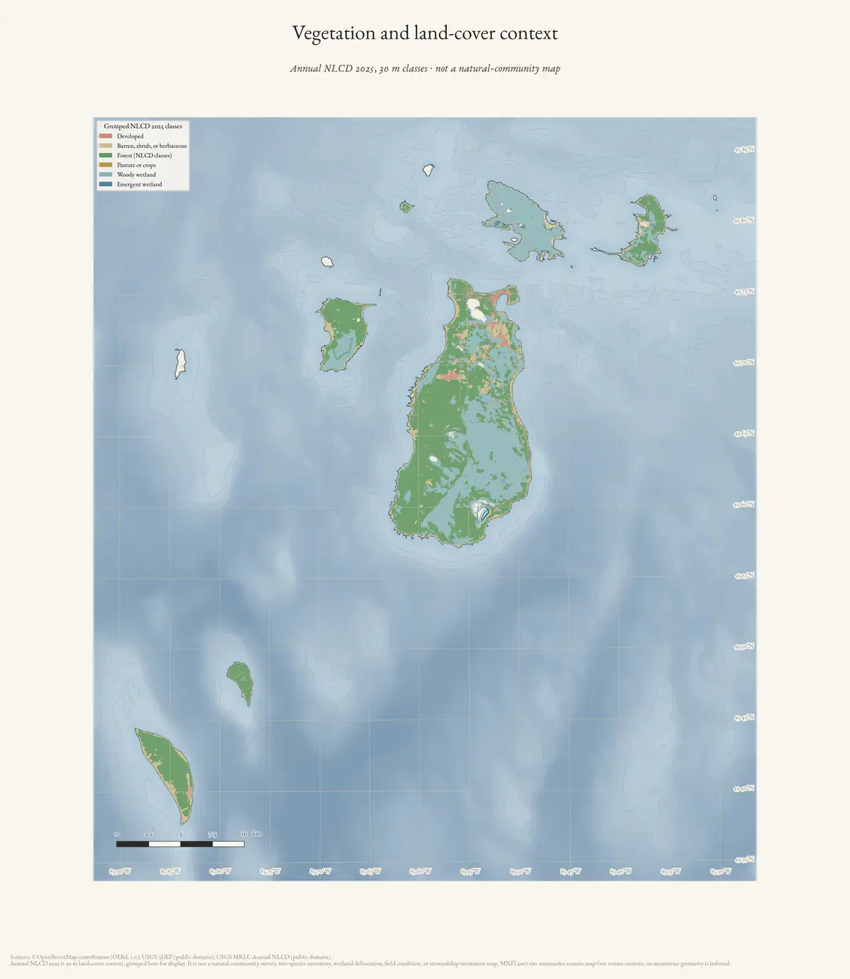
- Beaver Island Archive, *Vegetation and land-cover context of the Beaver Island archipelago* — plate drawn by this project. CC BY 4.0 for the drawing; underlying data under its own terms (see credit)Grouped land-cover context for seven islands at 30 m, as the habitat background stewardship works against. It maps cover types from satellite classification - not species occurrence, not invasion extent, and the plate's own description notes it is not an MNFI natural-community map. Credit: Drawn from the archive's own data in EPSG:3078. Map data © OpenStreetMap contributors (ODbL 1.0); USGS MRLC Annual NLCD and USGS 3DEP (public domain). No public copy of this file is known; the archive holds one and can provide it on request.output · maps · ecology · archipelago-ecology
- A participant relayed World Environment Day information and linked it to local outdoor and environmental awareness. It documents environmental messaging in the forum, not a Beaver Island conservation action.forum · www.beaverislandforum.com · 04 · t004981
- A participant, identifying Charlevoix County Conservation District involvement, offered native beach grass for island dune stabilization after an order was canceled. This documents a reported conservation-material opportunity, not proof of planting or project completion.forum · www.beaverislandforum.com · 04 · t004921
- A participant discussed possible uses for phragmites, including thatching and ethanol, while noting the plant as invasive. This documents community-level ecological speculation, not a tested control or utilization project.forum · www.beaverislandforum.com · 04 · t004787
- A participant shared external information about invasive pests in the Galápagos. It is comparative environmental discussion, not evidence about Beaver Island.forum · www.beaverislandforum.com · 03 · t003442
- A notice promoted an Earth Day environmental musical. It documents public environmental messaging, not a conservation action or impact.forum · www.beaverislandforum.com · 03 · t003347
Added 2 August 2026 · revised 3 August 2026. Recent changes
Cite this article
Beaver Island Archive, “Invasive species and ecological stewardship”, https://beaverislandarchive.org/themes/invasive-species-and-ecological-stewardship/, accessed [date], citing Beaver Island Forum, "Biology Project. HELP!", April 2005, topic 345. (and 24 further sources listed on the page).
Last revised 2026-08-03. Fill in [date] with the date you read it — this page is static and cannot know that.
BibTeX for “Invasive species and ecological stewardship”RIS for “Invasive species and ecological stewardship”