

- Dates
- 2015 – 2017
- Eras
- Modern era
- Concepts
- conservationenvironmentforestswetlandsagriculture
- Within
- Beaver Island archipelago
Summary
Joshua G. Cohen’s Natural Community Surveys of Beaver Island Archipelago was prepared for the Little Traverse Bay Bands of Odawa Indians Natural Resources Department and dated December 31, 2017. The held copy is a 168-page PDF and the official MNFI report record identifies it as Report 2017-11. The survey work covered the 2015, 2016, and 2017 field seasons and was designed to give resource managers and planners standardized baseline information for biodiversity stewardship, protection, management, restoration, and monitoring.
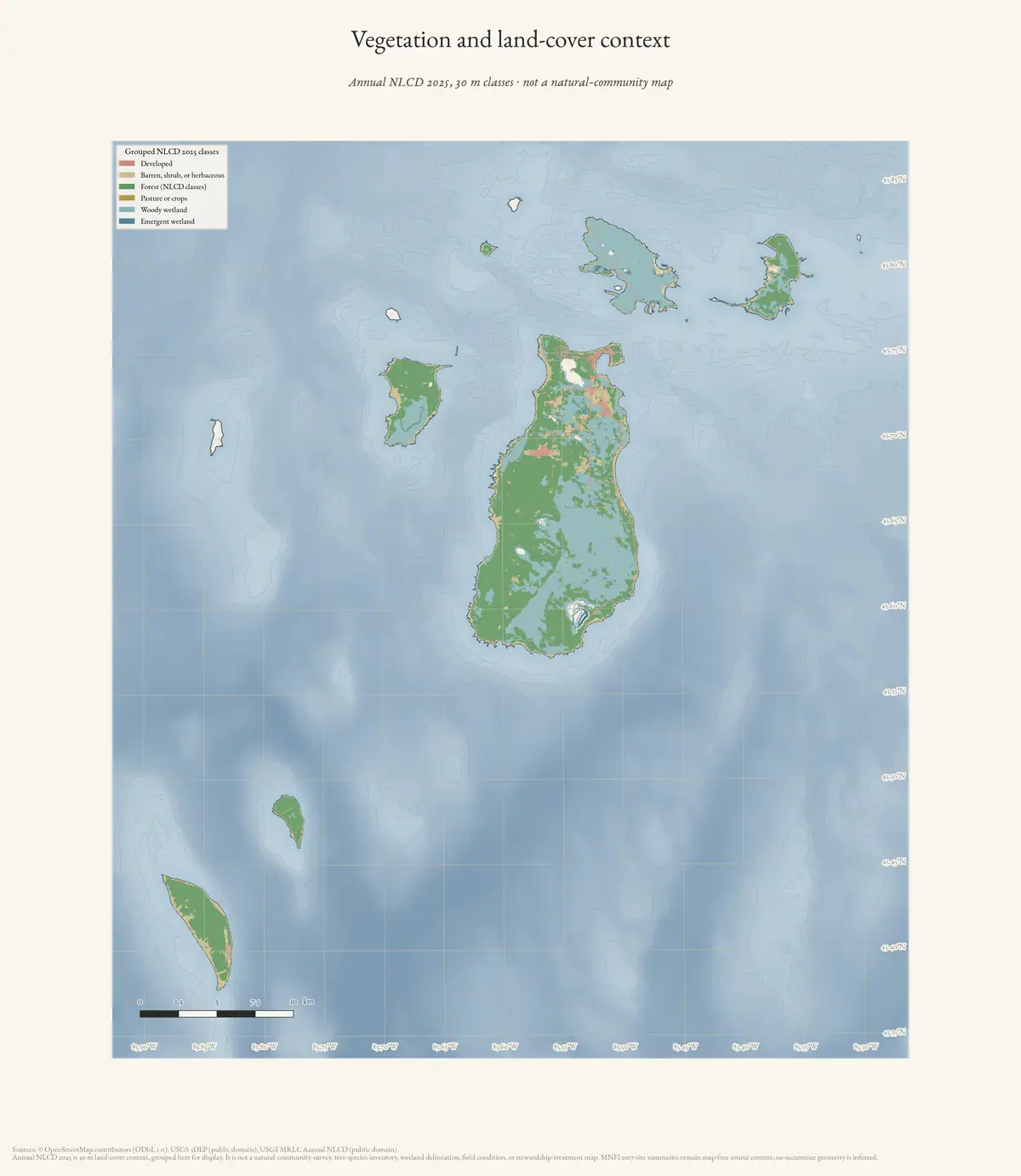
The report is now locally held and searchable. Its methods combine field surveys, aerial-photo interpretation, historical imagery, GIS analysis, GPS ground-truthing, soil and hydrology observations, tree aging and DBH measurements, plant inventories, threat assessment, and ecological-boundary mapping. The report’s 43 site summaries are therefore a much stronger basis for this archive’s forest, wetland, dune, shoreline, species, and stewardship connections than the earlier web-indexed totals alone.
All 43 numbered site summaries now have at least one page visually checked against the held PDF and preserved as evidence images. The set covers all 16 natural-community types and every EO in the normalized occurrence index. This is a complete one-page-per-occurrence audit, not an image audit of every continuation page in multi-page summaries.
Island-by-island survey frame
The report summarizes the survey as follows:
| Island group | Previously known element occurrences surveyed | New occurrences documented | Natural-community types represented | Total occurrences surveyed |
|---|---|---|---|---|
| Beaver Island | 10 | 7 | 9 | 17 |
| Garden and High Islands | 12 | 8 | 11 | 20 |
| Hog Island | 4 | 2 | 6 | 6 |
These are element-occurrence and community-survey counts, not acres, species counts, or parcel boundaries. “New” means newly documented in this survey sequence; it does not mean newly formed habitat.
The detailed survey-results section says that 16 natural-community types were visited: bog, boreal forest, coastal fen, dry-mesic northern forest, Great Lakes barrens, Great Lakes marsh, interdunal wetland, limestone cobble shore, mesic northern forest, northern fen, open dunes, poor conifer swamp, poor fen, rich conifer swamp, sand and gravel beach, and wooded dune and swale complex. The report distinguishes the 43 occurrences visited from the larger tables of previously known occurrences, some of which were not revisited during this project.
The project now also holds a normalized occurrence index. Each of its 43 records preserves the report’s site name, community type, island, EO ID, new-or- updated status, global and state ranks, element-occurrence rank, size in acres, printed report pages, and extraction line range. It also carries the report’s site description, threat assessment, and management recommendations as source-bounded text. This makes queries such as “all Beaver Island conifer swamps with deer-browse observations” or “all outer-island shoreline EOs with invasive threats” reproducible without pretending the report supplies modern GIS geometry.
The record-level facet lists make the ecological content easier to query without
turning keyword extraction into a new survey. soils_hydrology captures the
report’s pH, peat, sand, marl, substrate, saturation, water-depth, seepage, and
related observations; vegetation_tree_types captures canopy, understory,
ground-cover, tree, and floristic descriptions; animals_and_birds captures
observations such as deer, beaver, dragonflies, marsh birds, fish, crayfish,
and insects; and disturbance_and_stewardship captures logging, fire,
windthrow, flooding, invasive species, erosion, threats, and recommendations.
Each facet is a source-worded extract from the same site summary, not an
inferred presence/absence inventory.
Page map and Fox Islands scope
The downloaded PDF was verified against the held source copy: the SHA-256 is
22197bd0afaf772367eb64d02fa80ab552fbea5dc7c5f5287b72750f4d388194. A targeted
page index preserves both the printed report page and the PDF page number,
because the report has front matter and the two numbering systems differ.
The most useful report-level pages are:
- Printed pages 1–6 (PDF pages 7–12): introduction, Tables 1–3, and maps. These establish the survey frame as Beaver, Garden, High, and Hog Islands.
- Printed pages 7–10 (PDF pages 13–16): field methods, including plant lists, canopy structure, tree DBH and aging, soils, hydrology, disturbance, GPS, and ecological-boundary work.
- Printed pages 12–153 (PDF pages 18–159): the 43 site summaries, organized by natural-community type.
- Printed pages 154–160 (PDF pages 160–166): stewardship prioritization, Beaver-versus-outer-island comparison, and discussion.
The visual evidence subset is:
| Printed page | EO / site | Checked ecology content |
|---|---|---|
| 13 | 12097, Fox Lake Bog, Beaver Island | Acidic sphagnum peat over sand, hummock-hollow microtopography, stunted conifers, floating bog mat, pitcher-plant, and sundew |
| 16 | 20442, Greene’s Lake, Beaver Island | Weakly minerotrophic bog on deep acidic sphagnum peat over sand, groundwater and surface-water enrichment, hummock-hollow structure, leatherleaf/tamarack zones, and hydrologic alteration risk |
| 19 | 6311, French Bay, Beaver Island | Former cobble/sand shoreline, acidic sandy soils, old red pine and cedar, windthrow, deer-yard trails, dwarf lake iris, and yew absence |
| 22 | 7487, Garden Island Boreal Forest, Garden Island | Shoreline boreal forest on former cobble shore, shallow alkaline loams and organics over limestone cobble, cedar and white pine age evidence, windthrow, and dense cedar canopy |
| 25 | 4856, High Island, High Island | Former cobble and sand dunes, alkaline sands with a shallow acidic organic layer, white spruce over 100 years old, dense yew, and windthrow |
| 28 | 2437, Little Sand Bay, Beaver Island | Interdunal wetland and open-dune setting, beaver-flooded swale with flood-killed cedar, 145-year cedar and 180-year red oak, acidic sands, and deer browse |
| 32 | 3734, Hog Island, Hog Island | Alkaline peat and marl over wet gravelly sand and cobble, high-water inundation, marl pools, crayfish burrows, old cedar, and Hine’s emerald dragonfly habitat |
| 35 | 21328, Indian Harbor, Garden Island | Coastal-fen/marsh/cobble transitions, high-water inundation, shallow alkaline organics, groundwater seepage, sedges, rushes, and cedar |
| 38 | 7888, Jensen Harbor, Garden Island | Alkaline peat and marl over wet alkaline sands, sphagnum hummocks, marl pools and crayfish burrows, boundary adjustment with Taganing Marsh, and Hine’s emerald dragonfly habitat |
| 41 | 10574, Northcutt and Monatou Bays, Garden Island | Alkaline gravelly marl and shallow organics over sand, marl pools, sphagnum hummocks, sedge and pitcher-plant habitat, and suitability for Hine’s emerald dragonfly |
| 44 | 9513, Sweat Lodge Swale, Garden Island | Shallow alkaline organics over cobble, marl pool, bulrush and twig-rush, Kalm’s lobelia, native Phragmites, and cedar margin |
| 47 | 20453, High Island, High Island | Former dune shoreline, charcoal and likely severe fire history, hemlock over 100 years old, red pine over 120 years old, and shallow acidic soils over acidic sands |
| 49 | 9259, Pointe La Par, Beaver Island | Acidic dune ridges, alkaline wet swales and high water table, old oak and cedar, fire history, and deer herbivory |
| 53 | 20454, Nezewabegon Barrens, High Island | Wave- and wind-formed dunes, alkaline wind-blown sands, open pine/cedar/oak/juniper, Pitcher’s thistle, Lake Huron tansy, and invasives |
| 57 | 2179, Hog Island, Hog Island | High-water meadow and emergent zones, cedar margins, emergent graminoids, 30–120 cm water depths, and invasive narrow-leaved cattail |
| 60 | 13020, Indian Harbor, Garden Island | Marsh soils, water-depth zonation, fish spawning, shorebirds, American bittern, Virginia rail, and sora |
| 63 | 20450, Taganing Marsh, Garden Island | Adjacent Jensen fen and Taganing dune/swale, cobble transition, emergent and sand-gravel-flat zones, and cedar, tamarack, paper birch, and willow |
| 67 | 6089, Little Sand Bay, Beaver Island | Interdunal swale formation, Great Lakes water-level and storm burial, shallow alkaline sands, rare plants, and zebra-mussel shells |
| 71 | 6527, High Island | Storm-reworked limestone cobble, organic-soil development from driftwood and plant debris, seepage, alkaline gravelly sands, insects, and herptiles |
| 74 | 20447, Hog Island, Hog Island | High-water shift toward marsh, submerged cedar and paper birch, driftwood and plant-debris soil formation, shallow wet alkaline gravelly sands and organics, and sparse vegetation |
| 77 | 20448, Monatou Bay, Garden Island | State’s only A-ranked limestone cobble shore, high-water submergence, driftwood habitat and soil development, wet alkaline gravelly sands and organics, and marsh pockets |
| 80 | 20449, Taganing Shore, Garden Island | Storm- and lake-level-reworked cobble, wet alkaline sands and organics, marsh and fen inclusions, cobble spits, sparse vegetation, and non-native plants |
| 83 | 7843, Hog Island, Hog Island | Mature to old-growth former cobble/low-dune shoreline, red oak and sugar maple over 200 years old, fire and selective logging history, mull humus over acidic sands or cobble, and yew understory |
| 86 | 626, Martin’s Bluff, Beaver Island | Acidic/mull soil contrasts, 250-plus-year trees, deer browse affecting hemlock regeneration, beech bark disease, and a non-native earthworm |
| 89 | 20452, Nezewabegon Forest, High Island | Former dune shoreline, old-growth tree ages and DBH, acidic loamy sands, and the report’s deer-absence comparison |
| 92 | 10496, Red Oak Garden, Garden Island | Shallow alkaline loams over limestone cobble versus deeper acidic sand, old white ash and red oak, sugar maple canopy, pit-and-mound structure, and cut stumps |
| 95 | 10493, Southwest Old Growth, Beaver Island | Rolling moraine and steep terrace, 250–300-year hemlock, acidic mor humus and leached sands, large-tree gaps, groundwater discharge, beech bark disease, deer herbivory, and multiflora rose |
| 100 | 20446, Hog Island, Hog Island | Young fen polygons formed as wiregrass-sedge invaded shallow ponds, circumneutral to alkaline saturated peat, pitcher-plant, bladderwort, cranberry, native Phragmites, and willow/ash/tamarack/cedar margins |
| 102 | 11804, Garden Island Harbor | Floating peat, marl, alkaline pH, wet sands, beaver activity, crayfish burrows, glossy buckthorn, and Hine’s emerald dragonfly survey need |
| 106 | 530, Cable Bay, Beaver Island | Low parabolic dunes, fine wind- and wave-worked alkaline sands, Pitcher’s thistle, Lake Huron tansy, scattered cedar/pine/birch/fir, deer browse, residential and foot erosion, zebra shells, and invasives |
| 109 | 10698, High Island | Alkaline dune sands, ancient cedars in blowouts, Pitcher’s thistle, and Lake Huron locust |
| 112 | 6701, Lookout Point, Beaver Island | Mile-scale foredune and dune complex, water-level-driven beach and interdunal turnover, alkaline sands, Pitcher’s thistle, Lake Huron tansy, willows, residential and foot pressure, and invasives |
| 114 | 20737, McCauley Point, Beaver Island | Alkaline sands, blowout with ancient cedar snags and former forested dune, interdunal wetland and gravel-dune field, Pitcher’s thistle, marram, residential and foot erosion, and bladder campion |
| 117 | 10808, McFadden Point, Beaver Island | High parabolic dunes and gravel flats with a long blowout, alkaline sands, Pitcher’s thistle, Lake Huron tansy, young red pine, and off-road and foot impacts |
| 122 | 20688, Greene’s Lake Swamp, Beaver Island | Deep acidic peat, clay-rich till and drainage, groundwater seepage, hummock-hollow microtopography, black spruce, and tamarack |
| 126 | 2988, Egg Lake, Beaver Island | Peat over one meter deep, pH gradients from 4.5 to 6.8, floating mats, groundwater-driven zonation, 60-plus plant species, pitcher-plant, sundew, and bladderwort |
| 130 | 20690, Doty’s Swamp, Beaver Island | Variable-pH peat over wet sands, hummock-hollow structure, wildfire charcoal, windthrow and cedar layering, 284-plus-year hemlock, old-growth conifer structure, and deer browse |
| 133 | 20689, Greene’s Lake Swamp, Beaver Island | Cedar and hemlock over 150–275 years old, peat over alkaline sand, deer-yard and beaver evidence, water-level fluctuation, and rich conifer swamp structure |
| 137 | 9639, Hog Island, Hog Island | Rich conifer swamp adjoining marsh, fen, cobble, mesic, and hardwood-conifer communities, cedar over 300 years old, shallow circumneutral organics over wet alkaline sands, and windthrow/layering |
| 140 | 20692, Little Sand Bay, Beaver Island | Interdunal and boreal setting, beaver-flooded and flood-killed cedar, windthrow, 135-year cedar, circumneutral peat over sand, deer browse, and cut stumps |
| 144 | 13026, High Island | Wind-, wave-, and ice-maintained open beach, alkaline sand/gravel/cobble, sparse vegetation, Pitcher’s thistle, and shoreline invasives |
| 147 | 10977, High Island Bay, High Island | Two-mile unstable sand/gravel/cobble shore maintained open by wind, waves, and ice, with foredune, barrens, and forest connectivity; Pitcher’s thistle, mossy stonecrop, and spotted knapweed |
| 151 | 20451, Taganing Dune and Swale, Garden Island | Lacustrine dune-ridge/swale pattern, acidic surface organics over alkaline sands, saturated peat, standing water, old cedar, fire/logging history, and marsh-swamp-forest connectivity |
The machine-readable page index retains the corresponding PDF page numbers and
SHA-256 checksums; the occurrence crosswalk links all 43 images back to their
EO IDs through its visual_evidence field. There is one checked page for every
numbered occurrence and coverage of all 16 community types, but the selected
page does not constitute a full continuation-page audit for multi-page summaries.
North and South Fox Islands do not appear as survey islands, occurrence-table islands, or mapped occurrence records in this report. That is a documented scope boundary, not a finding that Fox Islands lack natural communities. The Fox Islands therefore need a separate source search—such as current or historical MNFI records, DNR natural-community layers, or a dedicated survey—if the archipelago analysis is to include them on equal terms.
The current extraction finds soil/hydrology, vegetation/tree, and disturbance/stewardship material in all 43 records, and animal/bird material in 39. The four records without an animal/bird facet are not evidence of an empty fauna; they simply contain no matching observation in the extracted site summary text.
The index also preserves a report-internal discrepancy: the introduction says that seven new Beaver Island occurrences were documented, while the 17 numbered Beaver Island site summaries contain six explicit “New EO” labels. The Garden/High and Hog counts align with their explicit labels. Both the narrative totals and the site-level labels remain available; the project does not silently choose one as the corrected value.
Island-level environmental crosswalk
The project crosswalk joins the occurrence index to the held environmental layers at the named-island level. It is a useful comparative frame, but it is not a substitute for MNFI occurrence polygons:
| Island | Island area (km²) | MNFI EOs | EGLE hydric-soil overlap (km²) | NWI wetland/deepwater overlap (km²) | Quaternary-geology overlap (km²) | Circa-1800 cover overlap (km²) | DNR-parcel overlap (km²) |
|---|---|---|---|---|---|---|---|
| Beaver Island | 151.076 | 17 | 64.536 | 47.824 | 148.965 | 146.537 | 51.097 |
| Garden Island | 20.321 | 12 | 4.037 | 20.201 | 18.572 | 17.829 | 18.068 |
| High Island | 15.074 | 8 | 6.523 | 1.058 | 14.491 | 14.209 | 14.393 |
| Hog Island | 10.412 | 6 | 1.832 | 3.674 | 9.175 | 8.544 | 8.999 |
These values are clipped to current OSM island polygons in equal-area EPSG:6933. They help compare the ecological setting around the four surveyed islands—for example, the larger hydric-soil footprint on Beaver Island versus Garden Island’s very high NWI-mapped wetland/deepwater footprint—but they do not assign any of those areas to a particular EO, landowner, or legal wetland boundary.
The Beaver Island table connects the ecological record directly to places already documented here: Fox Lake Bog, Greene’s Lake, French Bay, Little Sand Bay, Pointe La Par, Font Lake Old Growth, Lake Genesereth Old Growth, Martin’s Bluff, Southwest Old Growth, Cable Bay, Iron Ore Bay, Lookout Point, McCauley Point, McFadden Point, Sand Bay, Egg Lake, and Doty’s and Greene’s Lake swamps. The outer-island tables add Garden Island, High Island, and Hog Island sites including Indian Harbor, Jensen Harbor, Monatou Bay, Taganing Marsh and Shore, Nezewabegon Barrens and Forest, Garden Island Harbor, and Hog Island’s coastal, marsh, fen, forest, and swamp systems.
The report also records named rare or status-sensitive organisms and habitats, including dwarf lake iris, Pitcher’s thistle, Lake Huron tansy, Lake Huron locust, Hine’s emerald dragonfly habitat, and American bittern, Virginia rail, and sora observations at Indian Harbor. These observations are site- and survey-bounded; they are not a current island-wide species inventory.
The 2024 Peaine recreation plan summarizes an earlier 2016 survey slice as ten previously known Beaver Island occurrences plus five new occurrences, fifteen occurrences total, and nine community types. That difference is retained rather than treated as an error: the 2017 report includes a later field season and reports a different time slice.
Research significance
This report is the missing bridge between the project’s modern forest and wetland themes and the later planning language about natural-community protection. It provides site-level element-occurrence rankings, classifications, delineations, ecological boundaries, vegetation structure and composition, landscape and abiotic context, threats, management needs, and restoration opportunities referenced by the 2024 recreation plan.
Several cross-theme findings are especially useful:
- Beaver Island’s interior forest systems are repeatedly described as affected by deer browse, with effects on understory composition, conifer regeneration, and in some cases the apparent absence of yew. The report identifies deer density and browse pressure as a leading stewardship issue on Beaver Island, unlike the outer islands where deer were absent or nearly absent.
- Shoreline and dune systems carry a different threat profile. Invasive plants were most common in Beaver Island open dunes, while foot traffic and off-road vehicles also damaged dune systems. On Garden, High, and Hog Islands, invasive species were concentrated in shoreline ecosystems.
- Hydrology is not background detail: Great Lakes water-level fluctuation, storm disturbance, beaver flooding, peat depth, marl, alkaline sands, and groundwater seepage organize the transitions among fens, marshes, swamps, dunes, and forests. At Hog Island, high-water conditions were already shifting portions of a coastal fen toward Great Lakes marsh.
- The stewardship matrix is explicit rather than impressionistic. It combines ecological integrity, rarity, and threat severity. On Beaver Island the top scores are open-dune occurrences and two mesic northern forest occurrences; on the outer islands, Indian Harbor and Hog Island Great Lakes marsh score highest, followed by globally rare coastal fens. The report’s final synthesis identifies invasive control in open dunes, deer-browse control in forests, and invasive monitoring/control in outer-island coastal ecosystems as the leading priorities.
It also gives the archipelago a comparable survey frame. Beaver, Garden, High, and Hog Islands should not be collapsed into one ecological unit: the report surveys different numbers of occurrences and community types on each island or island group. The same caution applies to North and South Fox Islands, which are part of the broader archipelago conservation context but are not represented by these reported occurrence totals.
Evidence limits
The report is locally held, but it remains a 2015–2017 baseline rather than a current condition assessment. It should not be used to infer ownership, public access, parcel boundaries, completed restoration, or the current presence or absence of a rare species. The PDF’s maps and tables are authoritative for the report’s occurrence framework; they have not yet been converted into project GIS layers.
Open questions
- Can the report’s mapped occurrence boundaries be digitized or linked to an authorized MNFI/LTBB GIS layer without confusing them with parcel ownership?
- Which existing KB place records should receive structured links to each EO ID, community type, rank, size, and survey year?
- How did rankings or boundaries change between the 2016 plan slice and the 2017 report?
- Which occurrences overlap the held NWI/EGLE wetland layers, circa-1800 land-cover classes, DNR stands, or current protected-land polygons?
- Can the same survey chain be extended to North and South Fox Islands without importing Beaver Island occurrence claims?
See also
Sources
- Project-generated plant and vegetation evidence index for the Beaver archipelago (2026).Indexes exact plant-name matches in the occurrence descriptions and keeps them connected to the source occurrence, community type, facet, island, excerpt, and report locator. No public copy of this file is known; the archive holds one and can provide it on request.research · island_farming · indices · plant_vegetation_evidence_index
- Held user-supplied copy of the authoritative 168-page report. SHA-256: 22197bd0afaf772367eb64d02fa80ab552fbea5dc7c5f5287b72750f4d388194.research · island_farming · sources · mnfi_natural_community_surveys_beaver_archipelago_2017_11
- Searchable text extraction of Cohen 2017, MNFI Report 2017-11.Created with pdftotext -layout from the held PDF. Page references in this entry refer to the report page numbers printed in the PDF, not extraction line numbers. No public copy of this file is known; the archive holds one and can provide it on request.research · island_farming · mnfi_natural_community_surveys_beaver_archipelago_2017_11
- Generated by scripts/parse_mnfi_natural_community_surveys.py from the held PDF text extraction. Preserves report wording for site descriptions, threats, recommendations, and keyword-selected soil/hydrology, vegetation/tree, animal/bird, and disturbance facets, with EO IDs, ranks, sizes, locations, report pages, and extraction line references; it does not infer geometry or current condition.research · island_farming · indices · mnfi_natural_community_surveys_beaver_archipelago_2017_11
- Generated by scripts/build_mnfi_report_page_index.py. Separates printed report pages from PDF page numbers, records the report-level island-coverage boundary, points researchers to forest, wetland, shoreline, wildlife, and stewardship pages, and records 43 visually verified evidence pages covering all 43 numbered occurrence summaries and all 16 natural-community types.research · island_farming · indices · mnfi_report_page_index
- Maps 43 checked report pages to EO IDs, printed/PDF page numbers, evidence-image checksums, and topic notes. The set covers every numbered occurrence once and all 16 natural-community types; it does not infer occurrence geometry or expand the report's island coverage.research · island_farming · indices · mnfi_report_page_index
- Project-generated derived page images from the held MNFI report PDF.Forty-three claim-level images provide one visually checked page for each numbered occurrence summary in the report. They preserve soil, hydrology, tree-age and DBH, vegetation, animal, bird, rare-plant, disturbance, and stewardship claims at page level; continuation pages were not independently rendered when a summary spans multiple pages. No public copy of this file is known; the archive holds one and can provide it on request.research · island_farming · evidence
- Provenance for the project-generated MNFI occurrence index.Records the input PDF and text checksums, parser, generation time, and 43-record count. No public copy of this file is known; the archive holds one and can provide it on request.research · island_farming · indices · mnfi_natural_community_surveys_beaver_archipelago_2017_11.provenance
- Project-generated island-level environmental crosswalk for the MNFI occurrence index.Intersects the four named-island geometries with held hydric-soil, NWI, geology, circa-1800 land-cover, DNR parcel, protected-area, waterbody, and flowline layers. It supplies environmental context for the island containing each EO, not EO-specific overlap. No public copy of this file is known; the archive holds one and can provide it on request.research · island_farming · crosswalks · mnfi_occurrence_environmental_crosswalk
- Provenance for the project-generated MNFI environmental crosswalk.Records the source-index checksum, layer count, area CRS, and island-level intersection method. No public copy of this file is known; the archive holds one and can provide it on request.research · island_farming · crosswalks · mnfi_occurrence_environmental_crosswalk.provenance
- Official bibliography record describes the 2015–2017 field seasons, element-occurrence totals, natural-community counts, and the report’s baseline/stewardship purpose.
- Project retrieval provenance for the official MNFI report endpoint.Records the initial Incapsula challenge and the later user-supplied PDF, checksum, page count, and text-extraction paths. No public copy of this file is known; the archive holds one and can provide it on request.research · island_farming · sources · mnfi_natural_community_surveys_beaver_archipelago_2017_11.provenance
Added 2 August 2026 · revised 3 August 2026. Recent changes
Cite this article
Beaver Island Archive, “MNFI Natural Community Surveys of Beaver Island Archipelago, 2017”, https://beaverislandarchive.org/documents/mnfi-natural-community-surveys-beaver-archipelago-2017/, accessed [date], citing Project-generated plant and vegetation evidence index for the Beaver archipelago (2026). (and 11 further sources listed on the page).
Last revised 2026-08-03. Fill in [date] with the date you read it — this page is static and cannot know that.
BibTeX for “MNFI Natural Community Surveys of Beaver Island Archipelago, 2017”RIS for “MNFI Natural Community Surveys of Beaver Island Archipelago, 2017”