

- Eras
- Modern era
- Concepts
- wildlifebirdsanimalsconservationenvironmentforestswetlandscommunitytourism
- Within
- Beaver Island archipelago
Summary
The held Beaver Island record supports several different kinds of wildlife history: a 1950 hunting and game-management account, a 1960s sequence of local bird and waterfowl projects, a 1961 banding-and-recovery report, and modern state-land habitat planning. These records show that birds were part of island life as quarry, managed game, migratory subjects, nesting neighbors, and conservation concerns.
The 1849 GLO descriptions provide an earlier environmental and fishery baseline for that later record. Gull Island is explicitly described as valuable for a whitefish fishery; pages 0186–0188 add a fisherman’s village, an occupied log shanty, 15 fish houses, a few wigwams, and a surveyor-estimated 20 families and 120–150 people engaged in fishing. Hat, High, Ojibwa, Trout, and Whiskey pages tie boat landings, fish shanties, thin lake-margin soils, forest composition, fire, windthrow, and timber cutting to the islands’ human-use settings. They do not provide catch totals, bird counts, or a complete census, but they keep fishery and habitat context from beginning only in the modern management era.
They should not be collapsed into a single “wildlife population” story. The 1950 account discusses introduced game birds and planned observation; the 1966 Round Lake reports describe a community goose project; the 1961 article describes banding and a long-distance recovery; and the 1962 ferry story is an anecdotal nesting observation. Each has a different evidentiary status.
Planning-era species and stewardship context
The Beaver Island planning natural-resource evidence crosswalk, 2017–2024 adds a dated policy and visitor-information layer. The plans describe Beaver Island as a migratory-bird stopover, connect fish and wildlife to named lakes, wetlands, forests, and culverts, and preserve rare-species, invasive-species, forest-disease, monitoring, and stewardship concerns. They are useful for explaining why later surveys and management records exist; they are not a standardized bird survey, occupancy layer, abundance estimate, or complete fauna inventory.
The map-plate index Beaver Island Master Plan ecology map-plate evidence, 2017–2024 adds only habitat-setting context: dated wetland, inland-water, dune, soil, slope, and elevation plates. It does not turn a planning map into a species record, and its selected-archipelago Fox omission is retained as map coverage rather than interpreted as ecological absence.
The Seven-island ecology connectivity matrix, 2026 makes that source asymmetry queryable across all seven islands. It keeps animal and bird records beside canopy, forest-inventory, plant, soil, and geology summaries, but labels the joins as island context rather than species-level habitat or population evidence.
Seven-island wildlife evidence frame
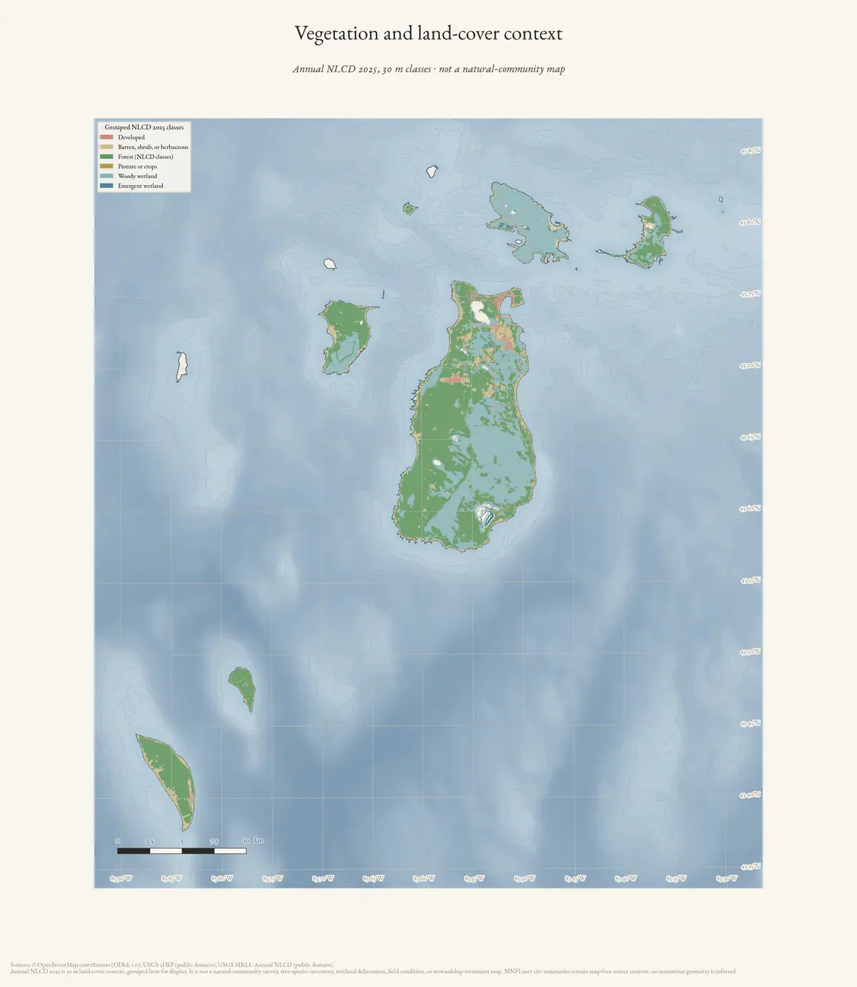
The matrix’s wildlife slice can therefore be read alongside the 2025 NLCD land-cover context — the same annual 30 m classification the plate below shows:
| Island | Wildlife/bird evidence rows | Wildlife/bird taxa | MNFI occurrences | 2025 NLCD forest (km²) | 2025 NLCD wetlands (km²) |
|---|---|---|---|---|---|
| Beaver Island | 48 | 47 | 17 | 73.9494 | 55.3338 |
| Garden Island | 11 | 14 | 12 | 0.0909 | 16.9335 |
| High Island | 21 | 23 | 8 | 8.4771 | 4.4064 |
| Hog Island | 10 | 12 | 6 | 5.4198 | 2.6847 |
| Whiskey Island | 4 | 6 | 0 | 0.2520 | 0.0405 |
| North Fox Island | 5 | 11 | 0 | 2.8593 | 0.0810 |
| South Fox Island | 13 | 16 | 0 | 10.5399 | 0.0450 |
The evidence-row and taxon columns count source-linked records and normalized labels in the matrix, not individual animals, abundance, survey effort, or species richness.1 The MNFI column counts named natural-community occurrences; it is not a complete wildlife-survey count. The NLCD columns are annual 30 m land-cover summaries, not habitat assignments for any record. The zero MNFI values for Whiskey and both Fox Islands are current exact-island coverage limits; they do not mean those islands lack animals, birds, forests, or wetlands. GLO, mapped-dune, management, GBIF, and other source-specific records remain separate layers.
Standardized survey bridge: 1999–2002
The MNFI 1999 progress report supplies a stronger survey-period baseline than the newspaper and management records. Its separated point counts recorded 133 bird species across spring migration and summer breeding surveys: 108 in the spring period and 109 in the summer period, with 51 long-distance migrants, 55 short-distance migrants, and 27 resident taxa. Beaver Island produced 76 spring and 89 summer species, while Garden produced 63 and 58. The counts used stations at least 250 m apart, a 50-m observation radius, defined time windows, and calm, dry conditions.2 They are comparative survey indices, not abundance estimates or a trend series.
The same report ties the bird observations to habitat and other fauna. It records a pair of Common Loons with a chick at Font Lake, visited-lake observations at Barney’s, Geneserath, and Greene’s Lakes, and a bounded Piping Plover effort at Donegal Bay’s McCauley Point and McFadden Point. Other historical Piping Plover sites were not surveyed, so this cannot be read as an island-wide negative result. The report also describes Red-shouldered Hawk call-playback work on suitable habitat and a Lake Huron locust site near open dune and forest edge.
The 2002 final synthesis explains how this type of observation became a spatial conservation record. Across its selected Great Lakes island groups, the five-year project documented 216 natural-community, rare-animal, and rare-plant occurrences—115 new and 101 updated—and identified 94 significant biodiversity areas, including 40 in the Beaver Island archipelago. It describes roughly 460 natural-feature occurrences digitized into MNFI’s GIS before significant areas were identified. Those historical planning units are not parcels, current habitat guarantees, or public occurrence points, but they provide an important precedent for connecting today’s soil, geology, land-cover, forest, and wildlife indexes as separate evidence layers.
The 1999 and 2002 records therefore sit between the local observation history and the 2017–2024 datasets: they supply controlled survey effort and a documented GIS/planning workflow while retaining site, island, season, and non-detection limits.
Stocking, closure, and observation
The wildlife record begins here with human intervention as much as with observation. A 1951 retrospective attributes a Game Club stocking program to ringneck pheasants in 1922, later squirrels, deer, sharp-tailed grouse, ruffed grouse, and cottontail rabbits. A 1938 report instead says 17 deer were stocked in 1927 and 1928 and estimated about 500 deer when hunting reopened after a decade-long closure. The two deer counts are not reconciled: they are preserved as competing source claims, not averaged or silently corrected.
The sequence continued in the 1960s. A report describes 28 ruffed grouse released on Hog Island in 1961; another records six young wild turkeys released near Angeline Bluff after two adults died in transit. A 1964 newspaper estimate of roughly 100 turkeys near the south end of Beaver Island is useful as a follow-up observation, but it does not prove that the 1961 release alone caused that number or that the flock persisted afterward.
Migration and observation
C. C. Ludwig’s reported work provides the clearest movement record in this cluster: a Caspian Tern banded on Hat Island was later found on the South Carolina coast. The account also reports very large numbers of banded birds, but the original permit, banding sheets, and recovery record are not held. The event therefore preserves a lead and a documented community report, not a complete migration dataset.
The Emerald Isle swallow report supplies a different kind of evidence: two pairs repeatedly nested aboard a working ferry. It is valuable precisely as a small, place-linked observation, but the species and exact nesting dates remain unresolved.
Managed game and habitat
The 1950 report distinguishes sharp-tailed grouse, ruffed grouse, pheasants, and rabbits in a changing hunting regime. The 1966 Round Lake notices describe a planned Canadian-goose sanctuary with nesting rafts and a follow-up about birds wandering from the project area. The 1960 turkey notice is another planning record. These sources document human attempts to shape game populations; they do not prove establishment, survival, or ecological effect.
The 2017 and 2022 DNR plans move the record toward habitat structure. They identify bald-eagle territories, colonial waterbird sites, piping-plover habitat, wetlands, dunes, and forest types as management concerns. The 2022 plan’s management zones connect mature forests, rare communities, wildlife habitat, shorelines, and timber stands, while the 2025 proposal links deer pressure to sensitive vegetation and regeneration. Those are management frames and proposals, not complete species inventories or proof of completed work.
The MNFI natural-community surveys add a habitat-linked species layer. The French Bay boreal forest includes a local dominant population of dwarf lake iris. Hog Island coastal fen and nearby bays are described as potential habitat for Hine’s emerald dragonfly. High Island dunes support tens of thousands of Pitcher’s thistle and Lake Huron locust. At Garden Island’s Indian Harbor marsh, the 2017 survey observed two American bitterns, while Odawa DNR marsh-bird surveys documented Virginia rail and sora. These observations show how the wildlife record can be joined to specific forest, fen, dune, and marsh habitat; they do not establish population size, breeding success, or current occupancy.
The primary Powell-Cuthbert Piping Plover study adds a more precise coastal habitat layer. From 1987 through 1990, all described Beaver nests and five of eight High Island western-beach nests were behind the foredunes, on cobble and sand with sparse vegetation. The study also records willow, beach grass, bearberry, sedge-filled ephemeral pools, beach and dune widths, storm overwash, gull colonies, and predator or human-disturbance effects. It is direct evidence that bird habitat includes the foredune and inland cobble-sand mosaic, not just the lake-facing beach. No nest-coordinate layer is held, so the named sites and the measurements are kept as the study gave them and no point is inferred from them.
The 2011 USGS International Piping Plover Census provides the next time-stamped comparison. Its appendix names six Charlevoix County shore segments on Beaver and High Islands: Bonner’s Bluff/Landing, Donegal Bay and McCauley Point, High Island’s NE Spit and NW Side, Lookout Point, and McFaddin Point/Green’s Bay. Each recorded zero breeding pairs and zero adults during the June 2011 census, while several rows retained prior census-year sightings. The report’s High Island footnote also warns that a 2006 pair could not be assigned between the NW Side and NE Spit. This is a useful bridge from the 1987–1990 field study to later standardized monitoring, but it is not an island-wide or Fox-Island negative survey.
Outer-island connectivity and public observations
The seven-island evidence index keeps the outer islands in view without pretending that every island has the same survey depth. North Fox and South Fox now have current mapped-dune descriptions that connect open dunes, beaches, wetlands, old forest, amphibians, reptiles, insects, shorebirds, waterfowl, migrant songbirds, and bats. Hog Island adds a smaller but detailed coastal forest–limestone-cobble system. Whiskey Island has a direct 2010 Double-crested Cormorant colony study, while the MDNR plan separately records a limited island distribution baseline and a natural-heritage survey gap.
The GBIF snapshot supplies 5,097 retained public human observations for 36 selected taxa across the seven island polygons. Beaver dominates that snapshot with 4,908 records; Garden has 65, High 112, Hog six, and South Fox six, while no selected-taxon records were retained for Whiskey or North Fox.3 Those counts are observation effort and public-data coverage, not abundance or absence. A reported point, especially one with coarse or unknown precision, should not be turned into a sensitive nest, roost, or rare-plant location without checking the original publisher.
The resulting connectivity is useful because it separates three questions: what the island’s habitat can support, what a survey documented, and where a member of the public reported a taxon. The North/South Fox and Hog mapped-dune reports answer the first question; the MNFI, MDNR, Powell-Cuthbert, cormorant, and woodcock studies answer the second; and GBIF answers the third. Combining them supports comparison but never converts a soil, forest, or dune class into proof of species presence.
The Outer-island and legacy ecology evidence index makes that separation auditable across 68 normalized source records. It also keeps the 1999/2002 legacy island comparisons visible, so Bois Blanc and other comparison islands are not silently folded into the seven-island Beaver-archipelago counts.
Biodiversity appendix coverage
The 2017–2024 biodiversity index adds a compact species-and-community layer to the longer wildlife record. Its 304 source-defined rows include 14 natural communities, 13 rare plants, 17 rare animals, 158 native plants in the 2024 booklet, 31 invasive plants, 11 animals noted in the booklet, 22 amphibian or reptile distribution rows, and 38 rare-species distribution rows.
The 11-row animal extract consists of ten bird entries—bobolink, dickcissel, eastern meadowlark, eastern bluebird, grasshopper sparrow, horned lark, Lapland longspur, piping plover, savanna sparrow, and upland sandpiper—plus emerald ash borer. The 17 rare-animal rows add species such as American bittern, bald eagle, common gallinule, common loon, Lake Huron locust, little brown bat, merlin, northern goshawk, Piping Plover, smooth green snake, and yellow-banded bumble bee. The 22 amphibian/reptile rows include salamanders, frogs, turtles, and snakes across the MDNR plan’s seven-island frame.
These categories must remain distinct. A booklet bird entry is not equivalent to a field observation; an MDNR island-table mark is not an exact locality; and a rare-species distribution row is not an abundance estimate. Together they provide a searchable bridge among birds, herptiles, insects, plants, forests, wetlands, and island geography without manufacturing a complete fauna census.
Source-to-habitat signal frame
The records become more useful when organized by the ecological function a source actually documents. The table below is a comparison frame, not a suitability model. Each row keeps the species or animal signal, the landscape setting named by the source, and the boundary on what can be inferred:
| Signal family | Source-bounded evidence | Landscape connection | Interpretation limit |
|---|---|---|---|
| Marsh and wetland birds | American bittern at Indian Harbor marsh; Virginia rail and sora in Odawa DNR marsh-bird work; MNFI and 1999–2002 survey records | Emergent marsh, coastal fen, wetland forest edge, shallow water, and hydrologic variation | A named marsh observation or survey record does not establish island-wide wetland occupancy or abundance |
| Piping Plover | 1987–1990 Beaver/High field study, 2011 census segments, 2023 High Island nesting outcome, and protected-area records for Beaver, High, and South Fox | Foredune, cobble and sand, sparse beach vegetation, ephemeral pools, storm overwash, and shoreline disturbance | Nesting and census records are dated site evidence; protected habitat is not a current nest or population count |
| American woodcock | High Island study summaries and the secondary habitat synthesis identify old fields, shrub and young-tree cover, second-growth hardwood, and conifer forest | Early-successional patches, forest edge, moisture, lowland adjacency, and changing disturbance structure | The original Whitcomb field tables are not held; current NLCD, canopy, SSURGO, and GBIF layers cannot recreate occupancy or historic success |
| Colonial waterbirds and cormorants | MDNR plan records colonial nesting context on Beaver and High; the Whiskey crosswalk holds a direct 2010 Double-crested Cormorant colony study | Island shoreline, nearshore water, exposed rocks, and colony sites that vary with water level and weather | A plan-level designation and a colony study are different evidence classes and do not define a persistent colony boundary |
| Dune, barrens, and open-shore animals | Lake Huron locust and dune cutworm records; North and South Fox mapped-dune reports add toad, hognose snake, insects, shorebirds, waterfowl, migrant songbirds, and bats | Open dune, blowout, beach, interdunal wetland, sparse vegetation, and forest transition | Mapped habitat functions and rare-species distribution marks are not complete inventories or sensitive-location releases |
| Aquatic fauna and wetland invertebrates | Hine’s emerald dragonfly, crayfish, pondsnails, pea clams, fish-spawning, and other records are retained in the aquatic-fauna and MNFI indexes | Fen groundwater, marl, ponds, marsh, streams, lake margins, and wetland–forest interfaces | Aquatic records require their own waterbody and survey context; nearby forest or soil classes do not prove aquatic occurrence |
| Deer, beaver, and forest disturbance | DNR/MNFI records describe deer browse, deer yards, beaver flooding, fire, windthrow, and regeneration concerns | Forest age structure, lowland conifer, wetland edges, shrub cover, coarse woody debris, and hydrologic change | Management observations identify a process or concern, not a density estimate, causal attribution, or current condition across an island |
The frame shows how far the evidence actually reaches: birds and animals are linked to named wetlands, dunes, shorelines, forest structure, soil moisture and disturbance only where a source makes that connection. The underlying indexes retain the stronger separation among occurrence, survey effort, management action, habitat description, and public observation.
Open questions
- Can original bird-banding or U.S. Fish and Wildlife Service records identify the full species and recovery series?
- Did the 1966 Round Lake goose sanctuary and the 1960–61 turkey plans produce lasting populations?
- Which local photographs, ferry logs, or naturalist notebooks identify the swallow species?
- What DNR or MNFI surveys document deer density, forest regeneration, and bird occurrences over time?
- How can species-level evidence be connected to habitat without publishing sensitive nesting or rare-species locations?
See also
- Pre-settlement landscape and environmental history
- Lumbering
- Forest types and tree history
- C. C. Ludwig reports Beaver Island bird-banding recoveries, 1961
- Perch Fishing and Bird Hunting on Beaver Island in 1950
- Beaver Island Game Club prepares a Canadian goose project at Round Lake, 1966
- Swallows nest aboard the Emerald Isle, 1962 report
- MDNR management plan for state-owned Northern Lake Michigan islands, 2017
- MDNR Beaver Island Implementation Plan, 2022
- Powell and Cuthbert Piping Plover habitat and reproductive success on Great Lakes islands, 1987–1990
- USGS 2011 International Piping Plover Census at Beaver and High Islands
- Outer-island and legacy ecology evidence index
Footnotes
-
Seven-island ecology connectivity matrix (2026), wildlife/bird, natural-community and annual-NLCD slices. The NLCD columns are the 2025 exact-island summaries; the 2021 summaries in the same record differ slightly. ↩
-
Michigan Natural Features Inventory, Biological Inventory for Conservation of Great Lakes Islands: 1999 Progress Report (Report 2000-11), bird-survey results and per-island richness, read through the held page-bounded crosswalk of that report (report pp. 13–14, 16–17). MNFI’s own PDF endpoint refused retrieval here; the extraction used a public full-text mirror, and the report remains the canonical reference. ↩
-
GBIF wildlife observations and island ecology crosswalk (2026): 5,097 retained observations, 36 taxa, seven islands. Nearly all Beaver Island records come from eBird, and 4,854 of them carry unknown coordinate precision. ↩
Sources
- The thread directed a student toward Central Michigan Biological Station resources and participant plant/animal photographs. These are research leads, not a complete species list or validated ecological survey.forum · www.beaverislandforum.com · 00 · t000345
- Participants observed unusually numerous road-crossing squirrels on West Side Road and Old Fox Lake Road but did not establish why they were present. This is an informal observation, not a wildlife survey or causal explanation.forum · www.beaverislandforum.com · 00 · t000896
- Participants tried to locate blueberry fields marked near Barney's Lake Road and reported small, sparse wild berries during a drought year. This is informal seasonal observation and a location lead, not a botanical survey, harvest record, or confirmation that the mapped fields remained accessible.forum · www.beaverislandforum.com · 00 · t000933
- A lost-dog notice followed by a reported recovery documents community animal recovery, not wildlife behavior.forum · www.beaverislandforum.com · 05 · t005554
- A participant documented an extended missing-cat search, sightings, and reward; it is a community notice, not an animal-control record.forum · www.beaverislandforum.com · 05 · t005482
- A participant reported a missing cat and local sightings; it documents a search, not verified wildlife information.forum · www.beaverislandforum.com · 05 · t005477
- A Wildlife Club contact request documents local hunting coordination, not harvest totals or regulatory findings.forum · www.beaverislandforum.com · 05 · t005502
- A participant reported a roaming dog near Wicklow Beach and Sand Bay; it documents a local lost-pet notice, not wildlife observation.forum · www.beaverislandforum.com · 05 · t005620
- A participant sought temporary care for a cat during winter travel; it documents a private animal-care request, not a shelter record.forum · www.beaverislandforum.com · 05 · t005595
- A first-party animal-fund notice promoted adoption/fostering and spay/neuter; it links to external news for shelter conditions, which is stronger for those claims than the forum post.forum · www.beaverislandforum.com · 05 · t005734
- A missing-cat notice was followed by participant-reported recovery of both cats; it documents community animal recovery, not an animal-control record.forum · www.beaverislandforum.com · 06 · t006065
- A participant reported a missing cat near the transfer station; it documents a local animal search, not wildlife observation.forum · www.beaverislandforum.com · 06 · t006064
- A Beaver Island Wildlife Club notice offered patches to successful turkey hunters and requested hunt information; it documents a club program and participant data collection, not a population survey.forum · www.beaverislandforum.com · 06 · t006136
- A playful thread reported escaped pet skunks and a participant-reported recovery and relocation; it documents a community animal response, not a verified wildlife-management account.forum · www.beaverislandforum.com · 06 · t006104
- A first-party Friends of Beaver Island Animals request sought portable fencing; it documents an animal-organization equipment need, not an animal population measure.forum · www.beaverislandforum.com · 06 · t006263
- A participant reported a missing cat after winter care; it documents a community animal search, not an animal-control record.forum · www.beaverislandforum.com · 06 · t006173
- A duplicate notice repeated the same missing-cat report; it is retained chronologically as a separate forum topic.forum · www.beaverislandforum.com · 06 · t006172
- A lost-dog notice followed by a reported owner recovery documents community animal recovery, not wildlife behavior.forum · www.beaverislandforum.com · 06 · t006568
- A notice and follow-up reported that a missing dog was found; it documents participant-reported resolution, not an animal-control record.forum · www.beaverislandforum.com · 06 · t006559
- A first-party parade invitation organized dogs and owners through Friends of Beaver Island Animals; it documents community advocacy, not an animal census.forum · www.beaverislandforum.com · 06 · t006420
- A forum promotion linked a deer photograph and stated that Quality Deer Management appeared beneficial; the view count and ecological inference are publisher/participant claims, not a population study.forum · www.beaverislandforum.com · 06 · t006767
- A lost-dog notice was already indexed in September; no duplicate added.forum · www.beaverislandforum.com · 06 · t006719
- A participant reported a missing dog and suspected coyotes based on other reported losses; this is a local, unverified account, not confirmed predation evidence.forum · www.beaverislandforum.com · 06 · t006608
- A participant reported a found cat near Circle M and sought its owner; it documents a local animal-recovery notice, not a wildlife observation.forum · www.beaverislandforum.com · 06 · t006815
- A participant reported a frightened, collar-wearing dog running along East Side Drive; it documents a lost-pet search, not an official animal-control record.forum · www.beaverislandforum.com · 06 · t006719
- A participant sought a home for an elderly cat with reported kidney issues; it documents a private animal-placement request, not a veterinary record.forum · www.beaverislandforum.com · 06 · t006735
- A participant reported a disturbing dead-rabbit incident on private property and made allegations about motive; the thread preserves a contested personal account, not verified identification or criminal findings.forum · www.beaverislandforum.com · 06 · t006734
- A lost-dog notice and follow-up reported that neighbors located and returned the dog; it documents community animal recovery, not wildlife behavior.forum · www.beaverislandforum.com · 06 · t006986
- The thread records a missing dog and participant-reported return; it is a community notice and outcome report, not an official animal-control record.forum · www.beaverislandforum.com · 06 · t006945
- A participant offered mixed-breed puppies for adoption and later reported two remained; it documents a private animal-placement notice, not a census of island dogs.forum · www.beaverislandforum.com · 07 · t007011
- A lost-dog notice and follow-up reported that island neighbors helped recover the dog; it documents community animal recovery, not wildlife behavior.forum · www.beaverislandforum.com · 07 · t007072
- Participants discussed a newspaper report about mainland eagles and wondered about island monitoring during severe winter conditions; the thread records an inquiry and comparison, not a population survey.forum · www.beaverislandforum.com · 07 · t007232
- A participant described seasonal morel sightings and advised novice foragers to have mushrooms identified; this is local participant knowledge, not a verified abundance survey or food-safety authority.forum · www.beaverislandforum.com · 07 · t007423
- A participant shared birding guidance asking residents not to disturb newly fledged birds, including grouse, and noted young birds dead along Kings Highway. This is a resident observation and linked stewardship advice, not a wildlife survey or agency record.forum · www.beaverislandforum.com · 13 · t013203
- A resident asked about orange coloration on pine trees; a reply suggested fusiform rust and described informal pruning and oak removal. This is peer identification and anecdotal management advice, not a plant-pathology diagnosis or forest survey.forum · www.beaverislandforum.com · 13 · t013152
- A resident reported that a pair of loons on Fox Lake had a new hatchling and asked visitors to keep their distance. This is a dated resident wildlife observation and stewardship appeal, not a survey, nest-monitoring, or population record.forum · www.beaverislandforum.com · 13 · t013258
- A white fox reportedly escaped from a local keeper and was reported back at 6 a.m. the next day. This is participant testimony about a bounded animal-recovery episode, not a wild-fox observation, species record, or animal-control report.forum · www.beaverislandforum.com · 13 · t013850
- A visitor planning to hunt turkey sought permission or suggestions for additional locations and said recent years had been difficult for finding turkeys. This is a hunter's anecdote and land-access request, not a population estimate, harvest record, or wildlife-management survey.forum · www.beaverislandforum.com · 14 · t014046
- A participant shared or commented on a photograph of biting insects. The forum record is an anecdotal visual lead, not an identified-species record, abundance survey, medical assessment, or entomological observation.forum · www.beaverislandforum.com · 14 · t014298
- A resident said hummingbirds were still feeding on Beaver Island's east side and described arrivals from the Upper Peninsula and Canada continuing into mid-October, advising clean, filled feeders. This is a resident observation and advice, not a banding study, migration count, or species survey.forum · www.beaverislandforum.com · 14 · t014701
- An image-led notice concerned deer checking during bow season. The archived text does not preserve the check location, procedure, dates, or agency, so this establishes only that a notice was posted.forum · www.beaverislandforum.com · 14 · t014716
- A participant asked when Certhia americana (the species name used in the post) migrates to Beaver Island. The only reply was political humor and supplies no ornithological evidence. This documents a bird-observation information question, not a migration date, species-presence confirmation, or seasonal pattern.forum · www.beaverislandforum.com · 18 · t018370
- A new forum member referred to the CMU Biological Station community associated with Warblers on the Water and said they had been asked to write a book about Beaver Island, requesting a TDS phonebook for help. This documents a self-reported research/writing intention and connection to an island birding program, not a completed book, authorship identity, scientific contribution, or birding result.forum · www.beaverislandforum.com · 17 · t017615
- Project-generated Beaver Island Master Plan natural-resource evidence crosswalk, 2017–2024.Described in this archive: Beaver Island planning natural-resource evidence crosswalk, 2017–2024.Adds planning-level bird stopover, fish and wildlife, rare-species, invasive-species, forest-disease, and stewardship context while preserving the explicit limits on occupancy, abundance, and survey completeness. No public copy of this file is known; the archive holds one and can provide it on request.research · island_governance · master_plan_natural_resource_evidence_2017_2024
- Project-generated Beaver Island Master Plan ecology map-plate evidence index, 2017–2024.Described in this archive: Beaver Island Master Plan ecology map-plate evidence, 2017–2024.Provides dated planning-map context for wetland, inland-water, dune, soil, slope, and elevation settings; it is habitat context, not species occurrence or occupancy evidence. No public copy of this file is known; the archive holds one and can provide it on request.research · island_governance · master_plan_map_plate_evidence_2017_2024
- Project-generated seven-island ecology connectivity matrix (2026).Described in this archive: Seven-island ecology connectivity matrix, 2026.Connects source-declared wildlife and bird records with tree, plant, forest, canopy, land-cover, soil, and geology context at island scale without inferring occupancy or habitat suitability. No public copy of this file is known; the archive holds one and can provide it on request.research · island_farming · crosswalks · archipelago_ecology_connectivity_matrix_2026
- Project-generated MNFI natural-community ecological connectivity matrix (2026).Connects 78 MNFI wildlife/habitat-signal rows to the same occurrences’ plant, tree, soil/hydrology, and disturbance excerpts. No public copy of this file is known; the archive holds one and can provide it on request.research · island_farming · crosswalks · mnfi_natural_community_connectivity_matrix
- Project-generated soil, substrate, hydrology, and landform evidence crosswalk (2026).Described in this archive: Soil, substrate, hydrology, and landform evidence crosswalk.Connects wildlife and bird habitat descriptions to source-preserved peat, cobble, dune, wetland, shoreline, and forest-substrate evidence without inferring species presence from a soil polygon. No public copy of this file is known; the archive holds one and can provide it on request.research · island_farming · indices · soil_landform_evidence_crosswalk
- Project-generated USDA 1974 soil, woodland, tree-type, and wildlife evidence index (2026).Described in this archive: USDA 1974 soil, woodland, tree-type, and wildlife evidence index.Preserves Table 4’s broad soil suitability ratings across all 11 habitat and wildlife columns, including 76 paired-page scan-verified rated rows; these are habitat-planning ratings, not species observations or occupancy. No public copy of this file is known; the archive holds one and can provide it on request.soils · indices · usda_soil_woodland_wildlife_evidence_index
- Project-generated USDA wildlife-habitat to island-scale SSURGO crosswalk (2026).Described in this archive: USDA wildlife-habitat ratings connected to island-scale SSURGO map units.Connects 61 exact-symbol map units, 283 SSURGO component records, and 18 Fox/outer-island series-name candidates to the USDA ratings while preserving composite-map-unit and current-condition limits. No public copy of this file is known; the archive holds one and can provide it on request.soils · indices · usda_ssurgo_wildlife_island_crosswalk
- Project-generated plant and vegetation evidence index for the Beaver archipelago (2026).Connects plant names in MNFI occurrence facets to animal, bird, soil, hydrology, and stewardship excerpts while preserving the distinction between list scope and occurrence evidence. No public copy of this file is known; the archive holds one and can provide it on request.research · island_farming · indices · plant_vegetation_evidence_index
- Project-generated wildlife and habitat evidence index for the Beaver archipelago (2026).Connects 2017 MNFI animal/bird excerpts to natural-community, soil, vegetation, stewardship, and island-scale land-cover context while preserving list, table, management, and observation limits. No public copy of this file is known; the archive holds one and can provide it on request.research · wildlife · indices · wildlife_habitat_evidence_index
- Project-generated aquatic fauna and fisheries evidence index for the Beaver archipelago (2026).Described in this archive: Aquatic fauna and fisheries evidence index for the Beaver archipelago, 2026.Adds source-separated crayfish, Hine’s emerald dragonfly, fish-spawning, pondsnail, GLO fishery-use, and federal fish-management records without converting them into a complete fauna inventory or habitat polygon. No public copy of this file is known; the archive holds one and can provide it on request.research · wildlife · indices · aquatic_fauna_fisheries_evidence_index_2026
- Michigan Agricultural College Experiment Station, *First Report of the Upper Peninsula Experiment Station* (1900), Beaver Island natural-history records.Described in this archive: First report of the Upper Peninsula Experiment Station, 1900.Adds a dated selective baseline of 27 molluscs, 8 arachnids, and 1 insect record while retaining historical names, named determiners, and unresolved modern taxonomy. No public copy of this file is known; the archive holds one and can provide it on request.integrated · 1900_beaver_island_natural_history_index
- Project-generated outer-island and legacy ecology evidence index (2026).Described in this archive: Outer-island and legacy ecology evidence index.Connects 68 source-separated records for Fox, Whiskey, Hog, Garden, High, Beaver, and legacy comparison islands, including mapped-dune communities, birds, bats, wetlands, forests, and dated survey gaps without treating coverage gaps as absence. No public copy of this file is known; the archive holds one and can provide it on request.research · wildlife · indices · outer_island_ecology_evidence_index
- Project-generated named stream crosswalk for the Beaver archipelago (2026).Described in this archive: Named stream crosswalk for the Beaver archipelago, 2026.Provides mapped-source context for the stream and fisheries records while keeping NHD/OSM/GNIS geometry separate from species observations and management narratives. No public copy of this file is known; the archive holds one and can provide it on request.research · places · archipelago_stream_crosswalk
- Project-generated GBIF wildlife observations and island ecology crosswalk (2026).Described in this archive: GBIF wildlife observations and island ecology crosswalk, 2026.Adds aggregate species-by-island comparisons between 5,097 selected public observations, historical wildlife evidence, and island-level forest, vegetation, wetland, soil, and geology context without making point-level habitat claims. No public copy of this file is known; the archive holds one and can provide it on request.research · wildlife · indices · gbif_archipelago_ecology_crosswalk
- Project source article: *Charlevoix County Herald*, 20 October 1950, “Perch Fishing And Bird Hunting at its Peak on Beaver Island.”Described in this archive: Perch Fishing and Bird Hunting on Beaver Island in 1950.Dated account of a reopened bird-hunting season, introduced sharp-tailed grouse and rabbits, and planned conservation observation; it does not establish stocking outcomes. No public copy of this file is known; the archive holds one and can provide it on request.kb · articles · events · beaver-island-perch-and-bird-hunting-1950
- Project source article: *Charlevoix County Herald*, 9 November 1951, “Beaver Island To Be Honored.”Described in this archive: Beaver Island Wildlife-Stocking Program from 1922.Retrospective chronology of ringneck pheasants, squirrels, deer, sharp-tailed grouse, ruffed grouse, and cottontail rabbits. Its 13-deer figure conflicts with the 17-deer figure in the 1938 report; both remain source-bounded. No public copy of this file is known; the archive holds one and can provide it on request.kb · articles · events · beaver-island-game-stocking-program-1922
- Project source article: *Charlevoix County Herald*, 22 July 1938, “Deer Hunting On Beaver Island.”Described in this archive: Beaver Island Deer Hunting Reopened for the 1938 Season.Reports an estimated 500-deer herd after a decade-long closure and a spring investigation that found feed and cover without over-browsing; it is not a harvest or population census. No public copy of this file is known; the archive holds one and can provide it on request.kb · articles · events · reopening-of-beaver-island-deer-hunting-1938
- Project research record for Beaver Island wildlife management, 1938–1950.Connects the 1938 deer report and 1950 perch/game report while preserving stocking, closure, introduced-species, planned-survey, and outcome limits. No public copy of this file is known; the archive holds one and can provide it on request.kb_research · beaver_island_wildlife_management_1938_1950
- Project research record for Beaver Island conservation orders, 1938–1952.Connects the formal deer, sharp-tailed-grouse/prairie-chicken, and cottontail-rabbit orders while retaining their effective periods and legal boundaries separately from population evidence. No public copy of this file is known; the archive holds one and can provide it on request.kb_research · beaver_island_conservation_orders_1938_1952
- Project source article: *Beaver Beacon*, July 1961, “Bird Banding.”Described in this archive: C. C. Ludwig reports Beaver Island bird-banding recoveries, 1961.Records the reported scale of C. C. Ludwig’s banding work and a Caspian Tern banded on Hat Island and later recovered in South Carolina; the original banding records are not held. No public copy of this file is known; the archive holds one and can provide it on request.kb · articles · events · beaver-island-bird-banding-and-hat-island-recovery-1961
- Project source article: *Beaver Beacon*, August 1961, sporting news.Described in this archive: Conservation Department releases 28 ruffed grouse on Hog Island, 1961.Reports 28 disease-free ruffed grouse released on Hog Island and a concurrent grouse census; it does not establish survival or a self-sustaining population. No public copy of this file is known; the archive holds one and can provide it on request.kb · articles · events · beaver-island-ruffed-grouse-release-hog-island-1961
- Project source article: *Beaver Beacon*, September and November 1961, “Wild Turkeys Arrive” and game news.Described in this archive: First wild-turkey release on Beaver Island, 1961.Records six young turkeys released near Angeline Bluff after two adults died in transit, followed by a report that the six appeared healthy; it does not establish later flock continuity. No public copy of this file is known; the archive holds one and can provide it on request.kb · articles · events · release-of-wild-turkeys-on-beaver-island-1961
- Project source article: *Beaver Beacon*, June 1962, “The Swallows Come Back to Beaver Island.”Described in this archive: Swallows nest aboard the Emerald Isle, 1962 report.A local recurring nesting observation aboard the ferry; the newspaper does not identify the swallow species. No public copy of this file is known; the archive holds one and can provide it on request.kb · articles · events · beaver-island-swallow-nests-emerald-isle-1962
- Project source article: *Beaver Beacon*, November 1964, “Game News.”Described in this archive: Beaver Island fall partridge, turkey, and deer report, 1964.Reports an estimated group of roughly 100 turkeys near the south end and a prior planting of 35, plus Garden Island partridge and duck hunting; these are contemporary newspaper observations, not a census or harvest register. No public copy of this file is known; the archive holds one and can provide it on request.kb · articles · events · beaver-island-november-game-news-1964
- Project source article: *Beaver Beacon*, March–April 1966, “Geese” and “Game News.”Described in this archive: Beaver Island Game Club prepares a Canadian goose project at Round Lake, 1966.Community plan and progress report for a Round Lake goose project; it does not establish release or nesting success. No public copy of this file is known; the archive holds one and can provide it on request.kb · articles · events · beaver-island-canadian-geese-sanctuary-project-1966
- Described in this archive: MDNR management plan for state-owned Northern Lake Michigan islands, 2017.State-land plan identifying bald-eagle territories, colonial waterbird sites, piping-plover critical habitat, and island-level forest and wetland context.research · island_farming · sources · mdnr_northern_lake_michigan_islands_plan_2017
- Described in this archive: MDNR Beaver Island Implementation Plan, 2022.Plan-level forest and wildlife-management context. The PDF remains URL-backed because Michigan.gov returns 403 to the project downloader.kb · articles · documents · mdnr-beaver-island-implementation-plan-2022
- Described in this archive: MNFI Natural Community Surveys of Beaver Island Archipelago, 2017.The held report records habitat-linked observations including dwarf lake iris, Hine’s emerald dragonfly habitat, Pitcher’s thistle, Lake Huron locust, American bittern, Virginia rail, and sora. These are site-specific observations, not an island-wide inventory.research · island_farming · sources · mnfi_natural_community_surveys_beaver_archipelago_2017_11
- Provides reproducible record-level access to habitat-linked species observations and animal/bird facets preserved in the report’s site descriptions.research · island_farming · indices · mnfi_natural_community_surveys_beaver_archipelago_2017_11
- Project-generated Beaver Island biodiversity appendices and island distribution index, 2017–2024.Described in this archive: Beaver Island biodiversity appendices and island distribution records, 2017–2024.Adds 17 MNFI rare-animal rows, 22 MDNR amphibian/reptile rows, 38 rare-species distribution rows, and an 11-row Beaver Island bird/insect extract. These are source-defined lists and table marks, not a complete current fauna inventory. No public copy of this file is known; the archive holds one and can provide it on request.research · island_farming · indices · beaver_biodiversity_2017_2024
- Described in this archive: MNFI Great Lakes Islands 1999 progress report crosswalk.Adds page-bounded standardized bird surveys, targeted Piping Plover, Common Loon, and Red-shouldered Hawk work, 18 new natural-community occurrences, Hog Island wetland observations, and Beaver aquatic sampling. The official PDF was access-challenged; the index preserves the public full-text mirror as an access limitation.research · wildlife · indices · mnfi_great_lakes_islands_1999_inventory_index
- Described in this archive: MNFI Great Lakes Islands 1998–2002 final inventory synthesis.Adds the five-year project totals, 40 Beaver-archipelago significant biodiversity areas, 216 documented occurrences, and the historical GIS digitization workflow. These are project-wide synthesis totals, not a current complete fauna inventory.research · wildlife · indices · mnfi_great_lakes_islands_2002_final_synthesis_index
- Project-generated visually verified MNFI page evidence, Report 2017-11.Forty-three checked pages provide one page per numbered MNFI occurrence across all 16 natural-community types and preserve image-level support for marsh birds and fish spawning, deer browse and deer-yard habitat, beaver activity, insects and herptiles, rare dune plants, Lake Huron locust, and shoreline invasive/disturbance context. No public copy of this file is known; the archive holds one and can provide it on request.research · island_farming · evidence
- Project-generated island-level MNFI environmental crosswalk.Connects habitat observations to island-level wetlands, forests, geology, circa-1800 cover, water, and protected-land context without claiming EO-specific overlap. No public copy of this file is known; the archive holds one and can provide it on request.research · island_farming · crosswalks · mnfi_occurrence_environmental_crosswalk
- Described in this archive: Powell and Cuthbert Piping Plover habitat and reproductive success on Great Lakes islands, 1987–1990.Primary 1987–1990 Beaver/High Island field study linking Piping Plover nests to foredunes, cobble/sand, vegetation, ephemeral pools, beach/dune widths, predators, storms, and human disturbance.research · wildlife · sources · powell_cuthbert_piping_plover_great_lakes_islands_1992
- Described in this archive: USGS 2011 International Piping Plover Census at Beaver and High Islands.Standardized 2011 census appendix with six named Charlevoix County shore segments on Beaver and High Islands; all six recorded zero pairs and zero adults, with prior-year flags retained and no geometry inferred.research · wildlife · sources · usgs_piping_plover_census_2011_ds922
- Described in this archive: Visually verified GLO survey observations of archipelago soils, terrain, and trees, 1845–1849.Adds an early shoreline-and-fauna context: the Hat page records a nearby stone islet covered with gulls, Gull Island is explicitly described as valuable for whitefish, and the expanded Hat, High, Ojibwa, Trout, Whiskey, and Gull pages preserve fish-shanty, fish-house, boat-landing, thin-soil, forest-disturbance, and lake-margin settings. These are surveyor observations, not population counts or modern habitat surveys. The holder's public portal is searchable but does not link this record directly; the archive holds a copy of the file and can provide it on request.research · land_cover · crosswalks · glo_ecology_crosswalk_1845_1849
- Described in this archive: Visually verified GLO modern island ecology observations, 1942.Preserves explicit 1942 gull nesting/resting use on Shoe Island and duck/gull nesting/resting use on Pismire Island, alongside dated gravel, humus, sparse-vegetation, and disturbance observations. It is not a bird census or current occupancy layer. The holder's public portal is searchable but does not link this record directly; the archive holds a copy of the file and can provide it on request.research · land_cover · crosswalks · glo_modern_ecology_1942
- Project-generated Beaver Island Archipelago wildlife and bird species evidence index, 2017–2024.Described in this archive: Beaver Island Archipelago wildlife and bird species evidence index, 2017–2024.Connects seven-island distribution marks, historical management actions, direct wildlife studies, protection rules, and dated habitat evidence while keeping evidence classes separate. No public copy of this file is known; the archive holds one and can provide it on request.research · wildlife · indices · archipelago_wildlife_bird_evidence_2017_2024
- Project-generated GBIF public wildlife observation snapshot for the seven named island polygons.Described in this archive: GBIF public wildlife observations within Beaver Archipelago island boundaries.Retains 5,097 human-observation records for 36 selected taxa with dates, publishers, coordinates, and precision classes. It measures public-data coverage, not species richness or absence. No public copy of this file is known; the archive holds one and can provide it on request.research · wildlife · indices · gbif_archipelago_observations
- Project-generated High Island American woodcock habitat crosswalk.Described in this archive: High Island American woodcock habitat crosswalk.Connects the historic woodcock study trail to old fields, shrub and young-tree cover, second-growth hardwood/conifer forest, soil moisture, canopy structure, and public observations without inferring current occupancy. No public copy of this file is known; the archive holds one and can provide it on request.research · wildlife · indices · high_island_woodcock_habitat_crosswalk
- Project-generated named aquatic and wetland place crosswalk (2026).Described in this archive: Named aquatic and wetland places crosswalk, 2026.Adds named lake, marsh, swamp, bay, beach, stream, and reef anchors that can be connected to bird, fish, wetland, dune, and forest records without inventing habitat or occupancy polygons. No public copy of this file is known; the archive holds one and can provide it on request.research · places · named_aquatic_wetland_place_crosswalk
- Project-generated North Fox Island mapped-dune, forest, vegetation, and wildlife evidence.Described in this archive: North Fox Island mapped-dune, forest, vegetation, and wildlife evidence.Preserves habitat-function statements for Fowler’s toad, eastern hognose snake, invertebrates, shorebirds, waterfowl, migrant songbirds, and bats in a dune–forest–beach mosaic. No public copy of this file is known; the archive holds one and can provide it on request.research · wildlife · indices · north_fox_mapped_dune_ecology_2026
- Project-generated South Fox Island mapped-dune, forest, vegetation, wetland, and wildlife evidence.Described in this archive: South Fox Island mapped-dune, forest, vegetation, wetland, and wildlife evidence.Preserves 2021 observations and habitat functions for toads, hognose snakes, insects, shorebirds, waterfowl, migrant songbirds, bats, monarchs, and wetland fauna without exposing sensitive locations. No public copy of this file is known; the archive holds one and can provide it on request.research · wildlife · indices · south_fox_mapped_dune_ecology_2026
- Project-generated Hog Island mapped-dune, forest, shoreline, vegetation, and wildlife evidence.Described in this archive: Hog Island mapped-dune, forest, shoreline, vegetation, and wildlife evidence.Connects mature coastal forest, limestone cobble, woody debris, fish, waterfowl, nearshore birds, insects, herptiles, and bats while preserving the mapped-dune point limits. No public copy of this file is known; the archive holds one and can provide it on request.research · wildlife · indices · hog_island_mapped_dune_ecology_2026
- Project-generated Whiskey Island ecology, wildlife context, and cormorant-study evidence.Described in this archive: Whiskey Island ecology, wildlife context, and cormorant study evidence.Adds direct 2010 Double-crested Cormorant colony, nesting, predation, and prey-consumption evidence alongside the separate 2017 management-plan distribution marks. No public copy of this file is known; the archive holds one and can provide it on request.research · wildlife · indices · whiskey_island_ecology_2010_2017
- A community advocacy post warned that abandoned and free-roaming cats may affect island birds, especially returning migrants and ground-nesting species, and linked Cornell Lab guidance. The local observations are anecdotal and the generalized national mortality figures are not treated as a Beaver Island estimate; this is an advocacy source, not a bird census or wildlife-management determination.forum · www.beaverislandforum.com · 17 · t017668
- Beaver Island Archive, *Vegetation and land-cover context of the Beaver Island archipelago*. CC BY 4.0 for the drawing; underlying data under its own terms (see credit)Grouped land-cover context for seven islands at 30 m, as habitat background. It maps cover types, NOT wildlife or bird records, and the plate's own description adds that it is not an MNFI natural-community map. Credit: Drawn from the archive's own data in EPSG:3078. Map data © OpenStreetMap contributors (ODbL 1.0); USGS MRLC Annual NLCD and USGS 3DEP (public domain). No public copy of this file is known; the archive holds one and can provide it on request.output · maps · ecology · archipelago-ecology
- Participants discussed holes in tree trunks and suggested pileated woodpecker activity. This is an informal observation and identification suggestion, not a wildlife survey or confirmed diagnosis of tree damage.forum · www.beaverislandforum.com · 04 · t004755
- A lost-dog notice reported an English Setter missing near the Marine Museum and a follow-up said the dog was found in a nearby garage. The recovery is participant-reported, not independently verified here.forum · www.beaverislandforum.com · 04 · t004639
- A participant shared a wildlife video and commenters discussed whether the bird was an owl or merlin. It documents informal wildlife interest, not a verified species identification or island observation.forum · www.beaverislandforum.com · 04 · t004212
- A lost-dog notice described a recently adopted dog unfamiliar with the island and sought help locating it. It documents a community search, not a verified outcome in the truncated notice.forum · www.beaverislandforum.com · 03 · t003943
- A lost-dog notice sought help finding a black Goldendoodle last seen near Allen’s Lakeview. It documents a participant report, not a verified recovery.forum · www.beaverislandforum.com · 03 · t003916
- A pest-control notice discussed seasonal insects and rodents and encouraged prevention. It documents a commercial service claim, not a measured pest survey.forum · www.beaverislandforum.com · 03 · t003746
- A notice reported a lost dog and later that the dog had been found. The recovery is participant-reported, not independently verified.forum · www.beaverislandforum.com · 03 · t003734
- A participant sought materials for wildlife rehabilitation fencing and cages. It documents a stated volunteer/conservation need, not a completed facility.forum · www.beaverislandforum.com · 03 · t003716
- A participant reported cat litter dumped along a road. It is an unverified environmental complaint, not an enforcement record.forum · www.beaverislandforum.com · 03 · t003588
- A lost-cat notice sought community help. It documents a participant report, not a verified recovery.forum · www.beaverislandforum.com · 03 · t003541
- A participant shared observations or images of white pelicans and orchids. It documents informal natural-history interest, not a verified survey or species record.forum · www.beaverislandforum.com · 03 · t003467
- A notice announced a Wildlife Club meeting. It documents club activity, not membership or decisions.forum · www.beaverislandforum.com · 03 · t003401
- Participants discussed identifying a warbler. It is an informal observation, not a verified bird survey.forum · www.beaverislandforum.com · 03 · t003326
- A participant shared an observation or discussion of merganser ducks. It documents community natural-history interest, not a formal record.forum · www.beaverislandforum.com · 03 · t003314
- A participant shared observations or images of swans and other birds. It documents informal natural-history interest, not a verified survey.forum · www.beaverislandforum.com · 03 · t003280
- A participant reported an island dog. It is a community animal notice, not a population or wildlife record.forum · www.beaverislandforum.com · 03 · t003231
- A participant reported seeing a quail-like bird near Mrs. Redding's Trail; another participant suggested it was more likely a ruffed grouse and discussed possible introductions. This is an unverified observation and identification debate, not a species record.forum · www.beaverislandforum.com · 02 · t002961
- A participant reported a missing cat near Barney's Lake Road and later reported that it returned home. This is a contemporaneous community notice and self-reported resolution, not an animal-control record.forum · www.beaverislandforum.com · 02 · t002801
- A participant reported observing a small black-and-white shorebird and proposed a black-bellied plover identification and migration context. This is an observation shared in discussion, not a specimen, survey, or formally verified bird record.forum · www.beaverislandforum.com · 02 · t002712
- A participant reported an eight-year-old cat missing near Barney's Lake Road. This is a community notice, not an animal-control record or evidence of predation.forum · www.beaverislandforum.com · 02 · t002713
- A pest-control operator reported seeing mice moving into houses and offered treatment. This is provider testimony and seasonal advice, not a scientific infestation survey.forum · www.beaverislandforum.com · 02 · t002661
- A forum notice promoted a Community Center program on songbird habitat and land stewardship with an outside conservation speaker. It documents planned public education, not a bird census or verified habitat assessment.forum · www.beaverislandforum.com · 02 · t002468
- A notice promoted a free talk by conservation scientist Phyllis Higman on rare Beaver Island plants. It documents planned outreach and a named speaker, not the talk's attendance or a new species record.forum · www.beaverislandforum.com · 02 · t002482
- A participant reported two huskies found at a home and later reported that their owners had been located. This is a community lost-and-found notice and self-reported resolution, not an animal-control record.forum · www.beaverislandforum.com · 02 · t002359
- A participant reported seeing six bald eagles in the harbor area. This is an unverified personal observation, not a formal wildlife survey or count.forum · www.beaverislandforum.com · 02 · t002232
- A notice advertised beginner dog agility and obedience classes at island indoor facilities. It documents planned recreation and animal training, not enrollment or class completion.forum · www.beaverislandforum.com · 02 · t002238
- A participant reported a grey-and-white cat found near Barney's Lake Road and sought its owner. This is a community notice, not an animal-control record or confirmed ownership resolution.forum · www.beaverislandforum.com · 02 · t002159
- A participant reported an older, partially deaf dog missing near Main Street and later reported that it had fallen into the water. This is a personal community account and self-reported outcome, not an animal-control or veterinary record.forum · www.beaverislandforum.com · 02 · t002134
- Participants debated deer sightings, doe harvest, food plots, and herd management, with one participant referring to research literature. This is contested community discussion, not a population survey, harvest analysis, or wildlife-agency finding.forum · www.beaverislandforum.com · 01 · t001999
- A participant circulated an article about cormorants and fishing and connected it to Beaver Island's Golden Bone fishing story. The linked article is stronger for its ecological claims; the forum documents local discussion and promotion.forum · www.beaverislandforum.com · 01 · t001750
- A participant shared photographs of Beaver Island wildflowers. This is a community image-based observation, not a botanical survey or verified species inventory.forum · www.beaverislandforum.com · 01 · t001745
- Two participants exchanged contemporary observations about an osprey pair and a dead tree used by the birds. This is dated community observation, not a nest survey, banding record, or population estimate.forum · www.beaverislandforum.com · 01 · t001662
- A participant reported seeing six American White Pelicans on the water with two cormorants. This is a dated eyewitness observation, not a systematic count or evidence of a lasting colony.forum · www.beaverislandforum.com · 01 · t001619
- A participant observed very few bees during chokecherry bloom, sought a hive for pollination, and was directed by the Chamber to Beaver Island Apiaries. This is a dated personal observation and local apiary lead, not a pollinator survey or evidence of colony decline.forum · www.beaverislandforum.com · 01 · t001161
Added 2 August 2026 · revised 3 August 2026. Recent changes
Cite this article
Beaver Island Archive, “Wildlife and bird life”, https://beaverislandarchive.org/themes/wildlife-and-bird-life/, accessed [date], citing Beaver Island Forum, "Biology Project. HELP!", April 2005, topic 345. (and 124 further sources listed on the page).
Last revised 2026-08-03. Fill in [date] with the date you read it — this page is static and cannot know that.
BibTeX for “Wildlife and bird life”RIS for “Wildlife and bird life”