

- Dates
- 1845 – 2026
- Eras
- Early American eraLumbering eraModern era
- Concepts
- environmentgeologysoilswetlandsforestsvegetationcartographyconservation
- Within
- Beaver Island archipelago · Beaver Island · Garden Island · High Island · Hog Island · North Fox Island · South Fox Island · Whiskey Island
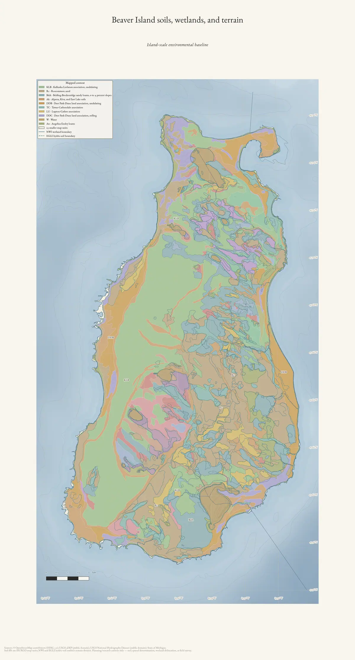
What this crosswalk adds
Soil evidence was already present in the corpus, but it was scattered among MNFI occurrence pages, GLO field notes, SSURGO intersections, physical-geology layers, and the newer EGLE mapped-dune reports. This crosswalk makes those records searchable together while preserving their different scales and dates.
It contains 124 evidence rows:
| Source layer | Evidence rows | What is preserved |
|---|---|---|
| MNFI 2017 occurrence crosswalk | 43 | Occurrence-level soil/hydrology descriptions and page/image anchors |
| MNFI 2015 Garden/High sites | 5 | pH, soil depth, parent material, and forest-site descriptions |
| GLO 1845–1849 | 54 | Page-bounded historical land, shore, water, and substrate observations |
| GLO 1942 | 4 | Dated gravel, boulder, humus, vegetation, and shore observations |
| EGLE North Fox | 6 | Mapped-dune, beach, blowout, vernal-pool, and hydrology descriptions |
| EGLE South Fox | 9 | Island-scale dune, bluff, seepage, beach, and interdunal-wetland descriptions |
| EGLE Hog | 3 | Wooded dune/swale, marsh, cobble-shore, and water-level descriptions |
The 16 input records without soil, landform, or water text are not silently treated as negative evidence: 13 are non-soil MNFI 2015 records and three are GLO 1845–1849 records. Their identifiers are retained in the JSON audit as excluded input records.
MNFI soil and hydrology gradients
The 2017 MNFI records show that “forest,” “bog,” or “shore” is not a sufficient soil description. Fox Lake Bog is a large ombrotrophic bog on poorly drained lakeplain, with deep sphagnum peat over sand; the peat is strongly acidic, saturated, and inundated along the lake margin. Greene’s Lake Bog adds a weakly minerotrophic condition, localized groundwater/surface-water enrichment, and sphagnum hummock-and-hollow microtopography.
French Bay’s boreal forest shows a different substrate pattern: a shallow acidic A horizon at pH 4.5–5.0 over acidic medium-textured sands at pH 5.0–6.0, with sand locally over cobble. The source links former sand shoreline to pine dominance and former limestone cobble shore to northern white-cedar dominance. That is a source-preserved ecological relationship, not a rule applied to every shoreline forest.
Across the 43 occurrence records, the extracted evidence terms include acidic, alkaline, calcareous, clay, cobble, dune, fen, groundwater, lakeplain, limestone, marl, marsh, organic material, peat, poorly drained, sand, saturated, seepage, sphagnum, swamp, till, water-level fluctuation, and wetland. The broader crosswalk vocabulary also captures historical stone and stony ground, beaches, bluffs, and dune blowouts. The JSON retains the exact source sentences behind every derived term.
Garden and High Island soil contrasts
The 2015 MNFI addendum provides unusually useful forest-soil comparisons. The Garden Island boreal forest is described on shallow alkaline loams and loamy organics over limestone cobble at pH 7.5–8.0. High Island’s boreal forest has alkaline sands, gravelly sands, and clayey sands at pH 7.5–7.8, with a shallow acidic organic layer at pH 4.5–4.8. High’s dry-mesic northern forest has a shallow acidic horizon over acidic sands at pH 4.5–5.0, while Nezewabegon Forest has acidic loamy sands at pH 5.0–5.5.
Garden’s Red Oak Garden is especially valuable because it preserves contrast within one named site: a southern polygon with shallow alkaline loams over limestone cobble and a northern polygon with deeper sands over cobble and an acidic organic/sand horizon. The vegetation and tree records should therefore be read with soil position and substrate, not as a single islandwide forest class.
Historical GLO substrate vocabulary
The GLO layer is not a modern soil survey, but it provides a rare historical vocabulary for the physical settings encountered by surveyors. The 1845–1849 records describe thin vegetable soils, sand, gravel, stone, cobble, marsh, swamp, low ridges, beaches, windfall, and fire disturbance across Big Beaver, Garden, Hog, Hat, High, Ojibwa, Trout, Whiskey, Gull, and both Fox Islands.
North Fox has page-bounded descriptions involving hard-pan, coarse gravel and pebbles, rocky or pebbly shore, clay banks, gravel beach, and lime pebbles. South Fox is described with fine sand, vegetable mould, and sand drifts. Big Beaver records repeatedly connect first-, second-, and third-rate ground to sugar, beech, birch, maple, hemlock, fir, cedar, spruce, pine, tamarack, ash, aspen, marsh, and swamp. These are surveyor line observations and historical land-use context, not inferred modern soil polygons.
The separate 1942 records for Shoe and Pismire add a later comparison point: low gravel/boulder or gravel/humus formations, sparse weeds and grass, small willows, and dated gull or duck use. They should remain separate from the 1845–1849 descriptions because their source form and date differ.
Fox and Hog landform processes
The EGLE mapped-dune records connect substrate to active landform processes. North Fox’s MDC 76 is a parabolic barrier-dune system with active foredune, blowouts, abrasion, sand burial, and aeolian movement, grading into vernal pools, old forest, and a sand-and-gravel beach. South Fox’s island-scale MDC 75 combines perched and parabolic dunes, beach ridges, clay bluffs, landslides, seepage, blowouts, and interdunal depressions. Its interdunal wetland occurrence shows standing water, water-level-dependent vegetation, calcareous indicators, and wildlife use that can vary by year.
Hog’s MDC 101 is lower relief: wooded dune-and-swale terrain meets Great Lakes marsh and limestone cobble shore. The source describes water-level fluctuation, storm waves, and ice shear reworking the cobble substrate and removing fine mineral and organic sediment. Only part of the larger MNFI occurrences lies in this mapped complex, so the record cannot be generalized to every Hog Island soil or forest stand.
Map context and scale discipline
The crosswalk attaches three kinds of island-level context:
- SSURGO mapunit names and clipped areas for all seven named islands, including sand, loam, dune, beach, bluff, gravelly-sandy-loam, and wetland-associated mapunits where the regional map reports them.
- The MNFI environmental crosswalk’s island-level hydric-soil, NWI, Quaternary, and circa-1800 context for the four islands represented there.
- The physical-geology crosswalk’s aquifer, SGMC, bedrock, fault, and glacial-lobe context for all seven islands.
These joins answer “what regional mapped context surrounds this island?” They do not answer “which soil polygon contains this individual MNFI occurrence?” The latter requires authorized occurrence geometry or field-level soil data. Representative EGLE points likewise remain representative points, not natural-community boundaries.
Seven-island SSURGO and aquifer frame
The synchronized matrix makes the island-scale soil comparison explicit. The SSURGO columns count map-unit intersections in the held polygon extract; “exact-symbol units” counts the subset whose map symbols resolve directly to a reported map-unit record; and component counts come from the associated SSURGO component tables. The last two columns keep the soil frame connected to the regional glacial-drift aquifer layer and show the largest reported units, not a complete soil-series list:
| Island | SSURGO units | Exact-symbol units | Components | Intersected area (km²) | Class-IV aquifer area (km²) | Two largest reported map units |
|---|---|---|---|---|---|---|
| [[place/beaver-island | Beaver Island]] | 33 | 31 | 111 | 149.738 | 148.822 |
| Garden Island | 7 | 6 | 22 | 19.979 | 18.532 | Alpena, Kiva, and East Lake soils; Lake beaches |
| High Island | 13 | 12 | 50 | 14.899 | 14.470 | Roscommon sand; Alpena, Kiva, and East Lake soils |
| Hog Island | 6 | 5 | 19 | 10.217 | 9.150 | Alpena, Kiva, and East Lake soils; Lake beaches |
| Whiskey Island | 2 | 2 | 5 | 0.485 | 0.366 | Alpena, Kiva, and East Lake soils; Lake beaches |
| North Fox Island | 12 | 3 | 35 | 3.414 | 3.343 | Detour sandy loam; Alpena gravelly sandy loam |
| South Fox Island | 13 | 2 | 41 | 13.964 | 13.848 | Deer Park sand; Eastport sand |
The Fox rows show why “map-unit count” and “resolved exact-symbol count” must remain separate: a regional intersection can be present even when the held symbol/name crosswalk resolves only part of the extract. The aquifer column is also a regional screening class, not a well-yield, groundwater-quality, or parcel-scale determination. None of these values assigns a soil series to a tree, MNFI occurrence, bird record, or property.
Open questions
- Can authorized MNFI/MiFI occurrence geometry be obtained for the 2017 and Fox Island records so soil and landform descriptions can be compared to actual EO boundaries?
- Which SSURGO mapunits correspond to the specific pH and substrate profiles in the MNFI site descriptions, and where do the regional boundaries become too coarse for that comparison?
- Can GLO pages be reconciled to stable PLSS and modern island geometry without turning line observations into polygons?
- Which groundwater, lake-level, and wetland-monitoring records can extend the dated peat, seepage, interdunal, and marsh evidence into a change series?
Sources
- Project-generated soil, substrate, hydrology, and landform evidence crosswalk (2026).Contains 124 source-preserving evidence rows from seven existing indexes, 39 transparent derived term counts, pH mentions, island summaries, and island-level context. No public copy of this file is known; the archive holds one and can provide it on request.research · island_farming · indices · soil_landform_evidence_crosswalk
- Project-generated crosswalk builder and provenance sidecar.Rebuilds the crosswalk and hashes all seven source indexes plus SSURGO, MNFI environmental, and physical-geology context inputs. No public copy of this file is known; the archive holds one and can provide it on request.scripts · build_soil_landform_evidence_crosswalk
- Project-generated MNFI 2017 soil, vegetation, and wildlife crosswalk.Described in this archive: MNFI soil, vegetation, tree, and wildlife crosswalk, 2017.Supplies 43 natural-community occurrence records with source-preserved soils/hydrology facets, visual page evidence, vegetation, tree, wildlife, and stewardship fields. No public copy of this file is known; the archive holds one and can provide it on request.research · island_farming · crosswalks · mnfi_soil_vegetation_wildlife_crosswalk
- Project-generated MNFI Garden and High Island 2015 biodiversity index.Described in this archive: MNFI Garden and High Island biodiversity, habitat, and acoustic surveys, 2015.Supplies five detailed forest-site soil descriptions with pH, depth, parent material, and tree structure. No public copy of this file is known; the archive holds one and can provide it on request.research · wildlife · indices · mnfi_garden_high_2015_biodiversity_index
- Described in this archive: Visually verified GLO survey observations of archipelago soils, terrain, and trees, 1845–1849.Supplies 54 records with page-bounded surveyor observations of sand, gravel, cobble, clay, thin soil, marsh, swamp, shoreline, ridges, and other landform context. Three source records had no soil/landform/water text and are listed as excluded input records. The holder's public portal is searchable but does not link this record directly; the archive holds a copy of the file and can provide it on request.research · land_cover · crosswalks · glo_ecology_crosswalk_1845_1849
- Described in this archive: Visually verified GLO modern island ecology observations, 1942.Supplies four page-bounded records for Shoe and Pismire Islands, including gravel, boulder, humus, sparse vegetation, and gull/duck shoreline context. The holder's public portal is searchable but does not link this record directly; the archive holds a copy of the file and can provide it on request.research · land_cover · crosswalks · glo_modern_ecology_1942
- Project-generated North Fox mapped-dune ecology index.Described in this archive: North Fox Island mapped-dune, forest, vegetation, and wildlife evidence.Supplies mapped parabolic-dune, beach, blowout, abrasion, sand-movement, vernal-pool, and hydrologic-connectivity descriptions. No public copy of this file is known; the archive holds one and can provide it on request.research · wildlife · indices · north_fox_mapped_dune_ecology_2026
- Project-generated South Fox mapped-dune ecology index.Described in this archive: South Fox Island mapped-dune, forest, vegetation, wetland, and wildlife evidence.Supplies island-scale perched/parabolic dune, bluff, landslide, seepage, beach, and interdunal-wetland descriptions. No public copy of this file is known; the archive holds one and can provide it on request.research · wildlife · indices · south_fox_mapped_dune_ecology_2026
- Project-generated Hog Island mapped-dune ecology index.Described in this archive: Hog Island mapped-dune, forest, shoreline, vegetation, and wildlife evidence.Supplies low-relief wooded dune/swale, Great Lakes marsh, limestone-cobble shore, water-level, storm-wave, and ice-shear descriptions. No public copy of this file is known; the archive holds one and can provide it on request.research · wildlife · indices · hog_island_mapped_dune_ecology_2026
- Project-generated SSURGO island soil ecology crosswalk.Described in this archive: Island-scale SSURGO soil crosswalk for the Beaver archipelago.Supplies seven-island mapunit intersections and reported mapunit names; these are regional soil-map context, not field-verified site determinations. No public copy of this file is known; the archive holds one and can provide it on request.soils · ssurgo_island_soil_ecology_crosswalk
- Project-generated archipelago physical-geology and hydrogeology context crosswalk.Described in this archive: Archipelago physical geology and hydrogeologic context crosswalk, 2026.Supplies island-level aquifer, SGMC, bedrock, fault, and glacial-lobe context without assigning a regional unit to a source occurrence. No public copy of this file is known; the archive holds one and can provide it on request.geology · crosswalks · archipelago_physical_geology_context
- Project-generated seven-island ecology connectivity matrix (2026).Described in this archive: Seven-island ecology connectivity matrix, 2026.Supplies the synchronized island rows used below to compare SSURGO map-unit intersections and regional aquifer context with forest, vegetation, wildlife, and geology evidence. No public copy of this file is known; the archive holds one and can provide it on request.research · island_farming · crosswalks · archipelago_ecology_connectivity_matrix_2026
- Beaver Island Archive, *Beaver Island soils, wetlands, and terrain* — plate drawn by this project. CC BY 4.0 for the drawing; underlying data under its own terms (see credit)The island-scale environmental baseline this crosswalk draws on: SSURGO map units, NWI and EGLE hydric-soil context, hydrography and 3DEP terrain. Credit: Drawn from the archive's own data in EPSG:3078. Map data © OpenStreetMap contributors (ODbL 1.0); SSURGO soils, USFWS National Wetlands Inventory, Michigan EGLE hydric soils, USGS 3DEP, and National Hydrography Dataset (public domain). No public copy of this file is known; the archive holds one and can provide it on request.output · maps · environment · beaver-island-environment
Added 3 August 2026. Recent changes
Cite this article
Beaver Island Archive, “Soil, substrate, hydrology, and landform evidence crosswalk”, https://beaverislandarchive.org/documents/soil-landform-evidence-crosswalk-2026/, accessed [date], citing Project-generated soil, substrate, hydrology, and landform evidence crosswalk (2026). (and 12 further sources listed on the page).
Last revised 2026-08-03. Fill in [date] with the date you read it — this page is static and cannot know that.
BibTeX for “Soil, substrate, hydrology, and landform evidence crosswalk”RIS for “Soil, substrate, hydrology, and landform evidence crosswalk”