

- Date
- 2017
- Eras
- Modern era
- Concepts
- environmentgeologyforestswetlandswildlifebiologyconservation
- Within
- Beaver Island archipelago
Summary
This crosswalk connects the physical and biological parts of the Beaver archipelago record without pretending they were collected at the same scale. It preserves all 43 natural-community occurrence records in the 2017 MNFI report, including direct statements about soil, hydrology, tree composition, tree age, wildlife, birds, disturbance, and management. It then attaches the current SSURGO crosswalk by named island so researchers can compare the source vocabularies while keeping occurrence boundaries separate from soil-map-unit boundaries.
The MNFI records cover four islands: Beaver (17 occurrences), Garden (12), High (8), and Hog (6). North Fox, South Fox, and Whiskey remain in the wider SSURGO and biodiversity research frame, but they do not have MNFI occurrence records in this particular report. That absence is a source-coverage fact, not evidence that those islands lack the community types or species.
Soil and habitat structure
The strongest result is that the report repeatedly describes ecological communities as transitions among substrate, water, shoreline process, and vegetation—not as isolated tree lists. The table counts occurrence records with a direct source mention; it does not count acres or abundance.
| Natural community | EOs | Islands | Direct soil and hydrology vocabulary | Direct tree or wildlife vocabulary |
|---|---|---|---|---|
| Bog | 2 | Beaver | Poorly drained lakeplain; deep sphagnum peat over sand; saturated, inundated, acidic, groundwater-influenced margins | Tamarack, black spruce, white and red pine; floating mats and pitcher-plant habitat |
| Boreal Forest | 4 | Beaver, Garden, High | Former sand or cobble shore; acidic to alkaline sand, gravel, loam, and cobble; fine-scale soil and hydrology gradients | Cedar, fir, birch, spruce, pine, oak; deer and beaver effects |
| Coastal Fen | 5 | Garden, Hog | Shallow alkaline peat, marl, gravelly sand, cobble, groundwater, and seepage | Cedar and tamarack; Hine’s emerald dragonfly habitat; crayfish burrows |
| Dry-mesic Northern Forest | 2 | Beaver, High | Acidic dune sands, shallow acidic A horizon, wooded swales, and variable water table | Fir, hemlock, birch, maple, oak, pine; deer-browse concerns |
| Great Lakes Barrens | 1 | High | Wind-blown and wave-worked alkaline dune sand over gravel/cobble and shallow organics | Pine, cedar, spruce, oak, birch, fir; Pitcher’s thistle |
| Great Lakes Marsh | 3 | Garden, Hog | Inundation, water-level fluctuation, sand/cobble spits, shoreline transitions, and organic margins | Cedar, birch, tamarack, spruce; American bittern, Virginia rail, sora, shorebirds, fish spawning |
| Interdunal Wetland | 1 | Beaver | Sandy shoreline, foredune, swale, gravel, and alkaline wetland substrate | Cedar, birch, tamarack, pine, spruce; beaver and Pitcher’s thistle context |
| Limestone Cobble Shore | 4 | Garden, High, Hog | Alkaline gravel, cobble, sand, organics, driftwood, and shoreline disturbance | Cedar, birch, tamarack; driftwood habitat for insects and herptiles |
| Mesic Northern Forest | 5 | Beaver, Garden, High, Hog | Acidic loamy sand, ground moraine, dune sand, cobble, humus, and groundwater discharge | Sugar maple, cedar, fir, yellow birch, hemlock, oak, ash; deer and beaver-influenced margins |
| Northern Fen | 2 | Garden, Hog | Saturated circumneutral-to-alkaline peat, marl, sand, and floating mat | Cedar and tamarack; dragonfly, crayfish, and beaver observations |
| Open Dunes | 5 | Beaver, High | Fine-textured wind-blown/wave-worked alkaline sand, foredunes, and beaches | Pine, cedar, birch, fir, spruce; Pitcher’s thistle, Lake Huron locust, deer/beaver signals |
| Poor Conifer Swamp | 1 | Beaver | Peat and sphagnum over poorly drained lakeplain/till with acidic groundwater influence | Tamarack, black spruce, white pine, red maple, yellow birch |
| Poor Fen | 1 | Beaver | Flat poorly drained lakeplain; saturated/inundated sphagnum and sedge peat; groundwater influence | Tamarack, black spruce, cedar, red maple |
| Rich Conifer Swamp | 4 | Beaver, Hog | Peat over wet sand, circumneutral-to-alkaline conditions, hummock/hollow microtopography | Cedar, fir, birch, black ash, tamarack, spruce; deer yards, browse, beaver flooding |
| Sand and Gravel Beach | 2 | High | Active alkaline sand, gravel, cobble, wave/ice abrasion, and unstable shoreline | Little persistent vegetation; Pitcher’s thistle at margins |
| Wooded Dune and Swale Complex | 1 | Garden | Acidic ridge organics/sand over alkaline sand; saturated alkaline peat in swales; standing water | Cedar, fir, birch, black ash, red pine, tamarack |
Several patterns are especially useful for joining the soil and geology work to the ecology record:
- Beaver’s bogs and poor fen are peat-on-sand or peat-on-lakeplain systems in which acidity, saturation, inundation, and groundwater influence determine the vegetation zones.
- Garden and Hog coastal fens and northern fens are alkaline peat/marl/sand or peat-mat systems. Their chemistry and water levels are part of the habitat evidence for Hine’s emerald dragonfly and crayfish burrows.
- Boreal forests are not one soil type. The report contrasts acidic sands and former sand shore with alkaline loams or loamy organics over limestone cobble; the substrate contrast accompanies shifts in cedar, pine, spruce, and hardwood dominance.
- Dune and beach communities are process-driven. Moving sand, wind, waves, and ice keep active beaches open, while stabilized ridges and swales support scattered trees, wetland pockets, and more complex forest mosaics.
Tree types, ages, and regeneration
The most frequently directly named tree in the four-island MNFI record is northern white-cedar, followed by white pine, balsam fir, paper birch, tamarack, red maple, hemlock, black spruce, red pine, white spruce, yellow birch, red oak, sugar maple, white ash, and black ash. These counts describe how many surveyed occurrences mention a tree in the preserved facet text; they are not a regional inventory or abundance ranking.
The report also preserves a useful age and disturbance sequence:
| Site | Directly reported age evidence |
|---|---|
| French Bay, Beaver | Red pine estimated over 140 years; northern white-cedars over 100 and 120 years |
| Garden Island Boreal Forest | Northern white-cedars over 145 and 165 years; white pine over 135 years |
| Little Sand Bay, Beaver | Northern white-cedar estimated at 145 years; red oak at 180 years |
| Nezewabegon Forest, High | Tree ages include approximately 70, 250, and 300 years in the source’s mesic-forest description |
| Greene’s Lake Swamp, Beaver | Cedar ages include approximately 150, 159, 180, and over 210 years in the rich-conifer-swamp record |
| Hog Island Rich Conifer Swamp | Northern white-cedar estimated over 300 years |
| Taganing Dune and Swale, Garden | Northern white-cedar estimated over 133 years |
These ages are individual cores or estimates within named occurrences, not dates for an entire stand. Windthrow, fire, selective logging, beaver flooding, coarse woody debris, and deer browse recur throughout the report. On Beaver, the report repeatedly interprets missing yew or hemlock regeneration and browsed saplings as possible deer effects. High Island’s absence of deer is explicitly treated as a comparison opportunity, not as a universal ecological condition.
Animals, birds, and habitat connectivity
The report’s animal evidence is habitat-linked and unevenly distributed:
- Indian Harbor on Garden Island is described as important for fish spawning and used by diverse shorebirds and secretive marsh birds. The 2017 survey observed two American bitterns; Odawa DNR marsh-bird surveys documented Virginia rail and sora there.
- Hine’s emerald dragonfly is reported as a population at Jensen Harbor and as apparent suitable habitat at several other fen sites. The crosswalk preserves those distinctions rather than converting every “suitable habitat” statement into a confirmed occurrence.
- Pitcher’s thistle is repeatedly associated with Beaver and High Island dune, barrens, interdunal, and beach-margin records. High Island’s open-dune record also names Lake Huron locust.
- Deer trails, browse, and likely winter-deer-yard use recur in Beaver’s boreal and rich-conifer systems and appear in records from High and Hog. Beaver activity or flooding is documented at several wetland and forest margins.
- Driftwood and plant debris on limestone cobble shores are described as habitat for insects and herptiles and as material for soil development.
The ecological bridge is therefore a chain rather than a single classification:
substrate and water regime -> natural community -> tree/plant structure -> wildlife habitat and disturbance
The machine-readable crosswalk retains the sentences at each link, along with report pages and source line ranges, so later mapping can test candidate relationships instead of silently turning them into facts.
SSURGO island context
The crosswalk attaches the current SSURGO results to the same named-island frame. This makes comparisons such as “Beaver’s MNFI occurrences and its current map-unit vocabulary” possible, but it does not claim that a soil unit intersects a particular MNFI occurrence. Fox Islands and Whiskey Island remain visible through the soil and biodiversity layers even though this MNFI report has no occurrence records for them.
| Island | MNFI EOs in this report | Current SSURGO survey area | Leading contextual soil labels |
|---|---|---|---|
| Beaver Island | 17 | MI029 | KLB Kalkaska-Leelanau; Rc Roscommon sand; BdA Belding-Breckenridge; Ak Alpena/Kiva/East Lake; DDB Deer Park-Dune land |
| Garden Island | 12 | MI029 | Ak Alpena/Kiva/East Lake; Lb Lake beaches; TC Tawas-Carbondale |
| High Island | 8 | MI029 | Rc Roscommon sand; Ak Alpena/Kiva/East Lake; BdA Belding-Breckenridge |
| Hog Island | 6 | MI029 | Ak Alpena/Kiva/East Lake; Lb Lake beaches; TC Tawas-Carbondale |
| North Fox Island | 0 in this report | MI089 | DtB Detour sandy loam; AsC Alpena gravelly sandy loam; DkF Deer Park sand |
| South Fox Island | 0 in this report | MI089 | DkF Deer Park sand; EdB Eastport sand; Du Dune land; Lk Lake bluffs |
| Whiskey Island | 0 in this report | MI029 | Ak Alpena/Kiva/East Lake; Lb Lake beaches |
The current SSURGO labels are a later mapping generation than the 2017 MNFI field descriptions and the 1974 county survey. Shared words such as sand, beach, dune, peat, loam, and cobble are useful search bridges, not proof of one-to-one map-unit equivalence or occurrence overlap.
Evidence limits and next research
The MNFI report surveyed selected natural-community element occurrences, not all land or all species. The normalized terms are exact substring matches to source-preserved facet sentences. Reported acres are sums of occurrence sizes and may not be additive or comparable to island area. Rare and sensitive sites remain at source-level granularity without new coordinates. The next useful step is a geometry-aware comparison where authoritative occurrence boundaries, SSURGO polygons, NWI wetlands, circa-1800 cover, and current forest layers are available together; until then, this crosswalk should remain a record of documented associations, not a habitat prediction model.
See also
- Forest types and tree history
- Wildlife and bird life
- Wetlands, inland waters, and hydrology
- Geology and landforms
- MNFI Natural Community Surveys of Beaver Island Archipelago, 2017
- Soil survey of Charlevoix County, Michigan, 1974
- Beaver Island biodiversity appendices and island distribution records, 2017–2024
Sources
- Project-generated MNFI natural-community ecological connectivity matrix (2026).Uses this crosswalk’s occurrence IDs as the join key for plant, tree, wildlife, and compact island-context summaries. No public copy of this file is known; the archive holds one and can provide it on request.research · island_farming · crosswalks · mnfi_natural_community_connectivity_matrix
- Project-generated plant and vegetation evidence index for the Beaver archipelago (2026).Extracts exact plant-name matches from this crosswalk’s preserved occurrence facets while retaining the occurrence, island, and evidence-limit boundaries. No public copy of this file is known; the archive holds one and can provide it on request.research · island_farming · indices · plant_vegetation_evidence_index
- Project-generated wildlife and habitat evidence index for the Beaver archipelago (2026).Extracts the crosswalk’s animal/bird facet signals and carries the related soil, vegetation, and stewardship excerpts into a source-separated wildlife layer. No public copy of this file is known; the archive holds one and can provide it on request.research · wildlife · indices · wildlife_habitat_evidence_index
- Project-generated tree and woody vegetation evidence index (2026).Aggregates the MNFI occurrence tree terms with GLO, guide, and MIFI evidence while retaining occurrence and source-specific limits. No public copy of this file is known; the archive holds one and can provide it on request.research · island_farming · indices · tree_woody_vegetation_evidence_index
- Project-generated MNFI soil, vegetation, tree, and wildlife crosswalk from 43 occurrence records.Preserves source facet sentences, report pages and line ranges, normalized soil/hydrology terms, direct tree terms, wildlife signals, reported pH/depth/age values, community summaries, and island-level SSURGO context. No public copy of this file is known; the archive holds one and can provide it on request.research · island_farming · crosswalks · mnfi_soil_vegetation_wildlife_crosswalk
- Provenance sidecar for the MNFI soil, vegetation, tree, and wildlife crosswalk.Records input checksums, generator, normalization method, record count, community count, and islands represented by MNFI occurrence records. No public copy of this file is known; the archive holds one and can provide it on request.research · island_farming · crosswalks · mnfi_soil_vegetation_wildlife_crosswalk.provenance
- Described in this archive: MNFI Natural Community Surveys of Beaver Island Archipelago, 2017.The report supplies the occurrence-level soil, hydrology, vegetation, tree-age, animal, bird, disturbance, and stewardship observations. The crosswalk retains the report’s site and occurrence scale.research · island_farming · sources · mnfi_natural_community_surveys_beaver_archipelago_2017_11
- Structured source derivative containing 43 occurrence records and four ecological facet groups.research · island_farming · indices · mnfi_natural_community_surveys_beaver_archipelago_2017_11
- U.S. Department of Agriculture, *Soil Survey of Charlevoix County, Michigan* (1974), with current SSURGO island crosswalk.Described in this archive: Soil survey of Charlevoix County, Michigan, 1974.Supplies current map-unit labels and calculated island intersections as contextual vocabulary. The join is by named island and does not claim EO-specific soil overlap. No public copy of this file is known; the archive holds one and can provide it on request.soils · ssurgo_island_soil_ecology_crosswalk
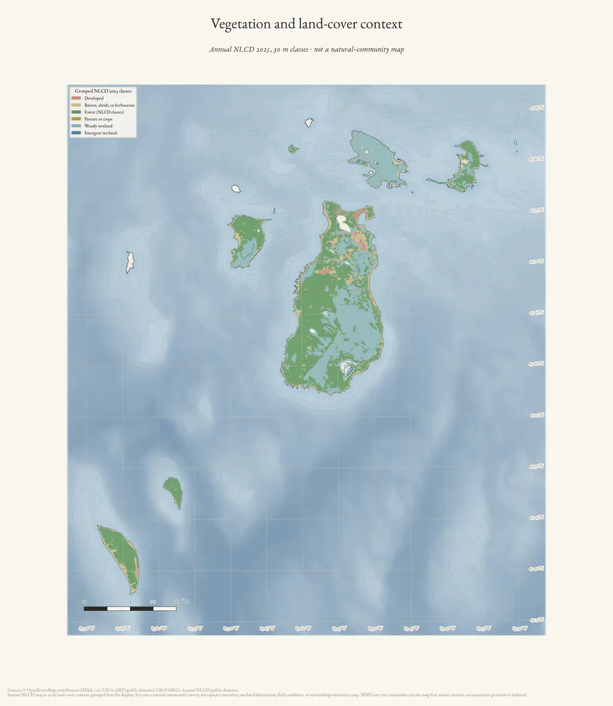
- Beaver Island Archive, *Vegetation and land-cover context of the Beaver Island archipelago* — plate drawn by this project. CC BY 4.0 for the drawing; underlying data under its own terms (see credit)Land-cover context for the archipelago. Read alongside this crosswalk rather than as its subject: the plate is 30 m NLCD and its own description states it is not an MNFI natural-community map, which is precisely the distinction this article is about. Credit: Drawn from the archive's own data in EPSG:3078. Map data © OpenStreetMap contributors (ODbL 1.0); USGS MRLC Annual NLCD and USGS 3DEP (public domain). No public copy of this file is known; the archive holds one and can provide it on request.output · maps · ecology · archipelago-ecology
Added 3 August 2026. Recent changes
Cite this article
Beaver Island Archive, “MNFI soil, vegetation, tree, and wildlife crosswalk, 2017”, https://beaverislandarchive.org/documents/mnfi-soil-vegetation-wildlife-crosswalk-2017/, accessed [date], citing Project-generated MNFI natural-community ecological connectivity matrix (2026). (and 9 further sources listed on the page).
Last revised 2026-08-03. Fill in [date] with the date you read it — this page is static and cannot know that.
BibTeX for “MNFI soil, vegetation, tree, and wildlife crosswalk, 2017”RIS for “MNFI soil, vegetation, tree, and wildlife crosswalk, 2017”