

- Eras
- Modern eraLumbering era
- Concepts
- wetlandsenvironmentgeologyforestsconservationagriculturetourism
- Within
- Beaver Island archipelago
- Media
- Beaver Island environmental detail — Northeast · Beaver Island environmental detail — Northwest · Beaver Island environmental detail — Southeast · Beaver Island environmental detail — Southwest · Beaver Island soils, wetlands, and terrain · Garden Island soils, wetlands, and terrain + 6 more
Summary
The archipelago’s soils, wetlands and terrain plate is the entry point for this theme. It keeps SSURGO map units, NWI wetland boundaries, EGLE hydric-soil boundaries, hydrography, and 3DEP relief visually distinct; the Beaver, outer-island, and Beaver-detail sheets keep that same source separation at a scale where individual map units can be read. These are planning and research context layers, not wetland delineations or parcel determinations.
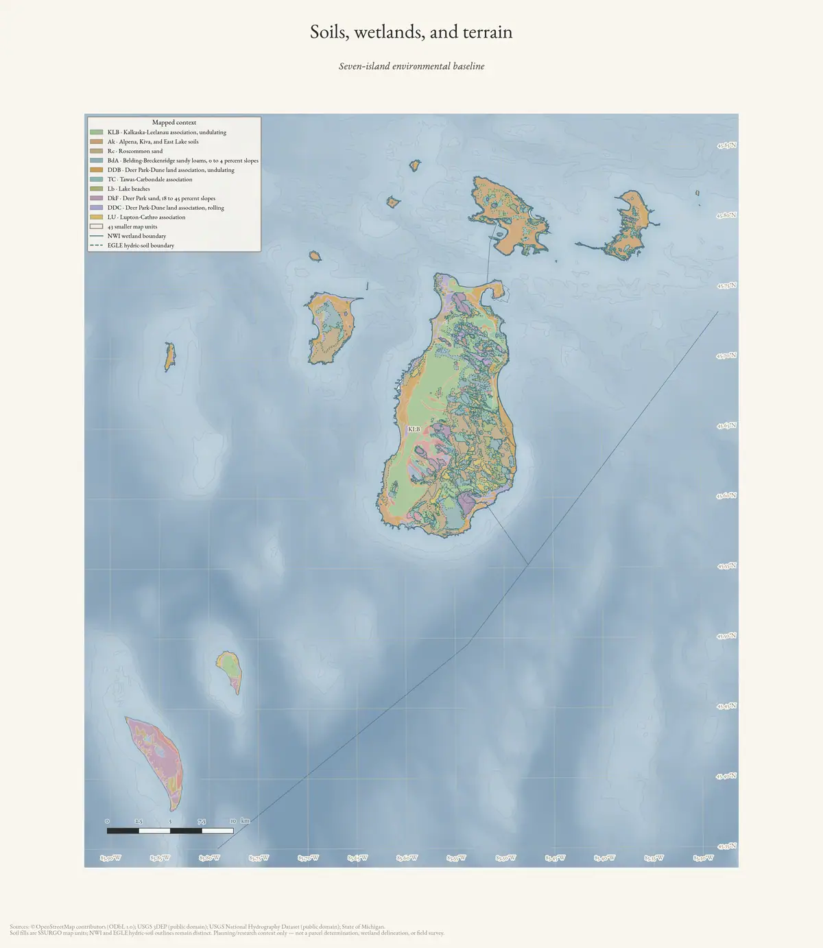
Wetlands are not a single kind of place in the Beaver Island record. That record holds coastal wetlands, inland marshes, fens and bogs, lake and stream systems, hydric soils, restoration-potential polygons, and historical language about swamps and drainage. This theme keeps those evidence classes connected without treating them as interchangeable.
Planning continuity, 2017–2024
The Beaver Island planning natural-resource evidence crosswalk, 2017–2024 keeps the planning record’s progression visible. The 2017 and 2023 plans describe coastal wetlands near the island’s eastern side, inland fens and bogs, ecosystem services, water-quality limits, and potential restoration; the 2024 recreation plan adds hydric-soil indicators, drainage and culvert concerns, fish passage, and bird and wildlife context. These statements make useful bridges to the held wetland, soil, stream, and fauna layers while remaining planning descriptions rather than legal delineations.
The map-plate companion Beaver Island Master Plan ecology map-plate evidence, 2017–2024 adds the visual layer: 2017 and 2023 Beaver plates, selected-archipelago plates in 2023, and 2024 recreation-plan wetland and soil plates. Because the archipelago selections do not label North Fox or South Fox, the index keeps their omission visible as map coverage and retains Fox wetland evidence from other sources separately.
The Seven-island ecology connectivity matrix, 2026 adds a seven- island comparison frame for reading wetland and hydrology context alongside forest, plant, wildlife, soil, and geology evidence. Its island-name joins do not assign any NWI, SSURGO, geology, or land-cover polygon to a named wetland, occurrence, or animal record.
Seven-island mapped wetland and fauna frame
The same matrix provides a useful screening comparison when its measures are kept in their source classes:
| Island | NLCD wetland class area, 2021 (km²) | NLCD wetland class area, 2025 (km²) | MNFI occurrences | Wildlife/bird evidence rows | Wildlife/bird taxa | SSURGO map units |
|---|---|---|---|---|---|---|
| Beaver Island | 55.2114 | 55.3338 | 17 | 48 | 47 | 33 |
| Garden Island | 16.8822 | 16.9335 | 12 | 11 | 14 | 7 |
| High Island | 4.4055 | 4.4064 | 8 | 21 | 23 | 13 |
| Hog Island | 2.6766 | 2.6847 | 6 | 10 | 12 | 6 |
| Whiskey Island | 0.0405 | 0.0405 | 0 | 4 | 6 | 2 |
| North Fox Island | 0.0819 | 0.0810 | 0 | 5 | 11 | 12 |
| South Fox Island | 0.0450 | 0.0450 | 0 | 13 | 16 | 13 |
The NLCD columns are the area classified as wetland in an annual 30 m land-cover summary; they are not NWI polygons, legal wetland determinations, water-depth measurements, or proof of persistence at a named site. MNFI values are named natural-community occurrences, while wildlife/bird values are source-linked evidence rows and distinct taxa—not abundance, occupancy, or species richness estimates. The zero MNFI values for Whiskey and the Fox Islands describe the current exact-island occurrence index, not the absence of wetlands or animals.1 Their GLO, mapped-dune, NWI/EGLE, and wildlife records remain separate evidence streams.
The MNFI 1999 inventory supplies a dated site narrative between the planning documents and the modern ArcGIS layers. At Hog Island’s Baldimore Bay Environmental Area, the report describes Great Lakes marsh, northern fen, interdunal wetlands, and swamp forest in narrow embayments. It names northern white-cedar, hardstem bulrush, rushes, Kalm’s lobelia, Arkansas mint, sedges, and twig-rush, and records four adult Common Terns. The narrow embayments were “almost completely dry during the 1999 low-water season”.2 That observation is useful for linking vegetation, water level, dune/swale landforms, and bird habitat, but it is not a current hydrologic baseline or legal wetland boundary.
The same report visited Font, Fox, Barney’s, and Geneserath Lakes, a Geneserath tributary, and Iron Ore Creek. Font Lake was generally less than two meters deep at visited locations, with a flocculent organic mat more than a meter thick over much of the bottom.3 Visual, SCUBA, dredge, and benthic kick-net methods make this a valuable aquatic evidence record, while the limited sites and sampling dates prevent it from being treated as a complete lake or stream inventory.
The 2002 MNFI synthesis then documents the map-making step: natural-community, rare-animal, and rare-plant occurrences were digitized into a GIS and used to identify significant biodiversity areas. Its 40 Beaver-archipelago areas are historical planning units, not wetland polygons or ownership boundaries. This precedent supports joining the current NWI, EGLE, SSURGO, circa-1800, forest, and wildlife layers while keeping the source-specific wetland evidence visible.
A linked water-and-habitat system
The 2017 Master Plan describes wetlands across the island interior, especially near inland lakes and the eastern side, and distinguishes coastal wetlands by their hydrological connection to Lake Michigan. It assigns them several functions—water filtering, fish/reptile/amphibian habitat, flood absorption, and bird-watching—and identifies inland lakes and streams as a connected network. It also names fens and bogs around the inland lakes and notes that some wetlands were historically drained or filled for agriculture or housing.
The modern ArcGIS stack makes that narrative queryable. The official NWI layer records modern wetland and deepwater classes; EGLE adds hydric soils, a dated 2005 NWI layer, and restoration-potential polygons. None of these layers alone answers whether a site is legally regulated, currently wet, historically drained, publicly accessible, or ecologically intact.
Named places as research anchors
Miller’s Marsh is the clearest place-level wetland record: the 2023 plan describes a large wetland ecosystem with sedges, a beaver lodge, turtles, research use, and a public trail, while earlier local reporting records turtle nesting and a nearby controlled burn. Lake Geneserath links inland water to fishing, recreation, and Strang-era naming. Gull Harbor Natural Area connects a coastal wetland to public-site planning, trails, ownership questions, and shoreline damage. Green Swamp and Egg Lake remain important candidates for map-to-name reconciliation rather than assumptions that every mapped polygon is the named feature.
The same method should be applied to the Fox Islands. They are part of the archipelago research frame, but the available county, state, and federal layers do not automatically mean that a Beaver Island polygon or ecological statement can be transferred to North or South Fox Island.
Historical change and comparison
The circa-1800 land-cover layer reconstructs historical vegetation from GLO survey notes; the 1849 GLO field descriptions record wet or burned landscapes in the surveyors’ own terms; soils describe drainage and parent-material patterns; and modern NWI/EGLE layers describe later mapped conditions. These sources can support a change-detection workflow—candidate persistence, drainage, filling, shoreline change, or reclassification—but not a direct before-and-after claim without matching boundaries, dates, and field evidence.
Lumbering and agriculture also belong in the hydrological story. Roads, wells, ditches, clearings, fills, timber harvest, and altered shorelines may have changed water movement, but a plan statement or a wetland polygon does not date those processes. The right next step is a place-specific comparison that joins NWI/EGLE, SSURGO, circa-1800 cover, hydrology, land ownership, and newspaper or planning evidence.
The MNFI baseline makes those connections concrete. It describes coastal fen, Great Lakes marsh, bog, poor fen, interdunal wetland, and rich or poor conifer swamp as systems organized by water levels, peat depth, substrate, seepage, beaver activity, windthrow, and fire. Hog Island’s coastal fen, for example, was surveyed during high-water years; portions were inundated by 5–20 cm and appeared to be transitioning toward Great Lakes marsh. At Indian Harbor, marsh water depth ranged from exposed or saturated meadow to roughly 150 cm of standing water, with substrate and water depth driving vegetation zones.
The report also gives the wetland map a biological and geological vocabulary: Fox Lake Bog and Greene’s Lake Bog occur in peatland settings; Greene’s Lake and Doty’s Swamps contain alkaline sands beneath peat; Little Sand Bay combines interdunal wetland, boreal forest, and rich conifer swamp; and the outer-island coastal systems grade among fen, marsh, limestone cobble shore, beach, and dune. This is useful for joining the ArcGIS layers to site narratives without claiming that a modern layer is a legal delineation or an exact MNFI EO boundary.
The Outer-island and legacy ecology evidence index makes the outer comparison explicit. South Fox contributes an island-scale mapped-dune system with a surveyed interdunal wetland; Hog contributes coastal marsh, fen, and wooded dune/swale evidence; and the older MNFI records preserve dated wetland and aquatic observations for Beaver, Garden, and Hog. These remain survey- and source-bounded records, not a substitute for wetland delineation.
Open questions
- Which mapped polygons are coastal wetlands, inland wetlands, lake bottoms, or stream-associated areas after clipping to authoritative island boundaries?
- Can the names Miller’s Marsh, Egg Lake Bog, Green Swamp, and Gull Harbor be matched to stable geometry across GNIS, NWI, EGLE, plans, and historical maps?
- Where do restoration-potential polygons overlap hydric soils, public land, protected areas, or documented drainage and agricultural change?
- What explains the EGLE draft-2015 and NWI-Plus zero-result query in the current archipelago frame?
- Can the Fox Islands receive the same wetland/soil/hydrology treatment without importing Beaver Island assumptions?
See also
Footnotes
-
Seven-island ecology connectivity matrix (2026). The NLCD columns are the 2021 and 2025 exact-island wetland-class summaries; the SSURGO column is the map-unit count intersecting each island in survey area MI029; the MNFI and wildlife columns are occurrence counts and source-linked evidence rows. ↩
-
Michigan Natural Features Inventory, Biological Inventory for Conservation of Great Lakes Islands: 1999 Progress Report (Report 2000-11), Baldimore Bay Environmental Area, Hog Island (report p. 56), read through the held page-bounded crosswalk of that report. ↩
-
Same report, Beaver Island aquatic-ecology sites (report pp. 21–22): four inland lakes and two streams visited; Font Lake generally under two metres at the visited locations, with a flocculent organic mat more than a metre thick over much of the bottom. ↩
Sources
- A north-end summer-home owner reported low water pressure and intermittent loss of water and asked about replacing a suspected shallow well point with a deeper well. This is a firsthand property problem and request for informal advice, not a hydrogeological diagnosis, well inventory, cost estimate, or proof that the proposed replacement occurred.forum · www.beaverislandforum.com · 16 · t016416
- Project-generated Beaver Island Master Plan natural-resource evidence crosswalk, 2017–2024.Described in this archive: Beaver Island planning natural-resource evidence crosswalk, 2017–2024.Adds section-bounded planning evidence for coastal and inland wetlands, hydric soils, water resources, fish passage, flooding, bird habitat, and restoration or protection recommendations without treating the plans as wetland delineations. No public copy of this file is known; the archive holds one and can provide it on request.research · island_governance · master_plan_natural_resource_evidence_2017_2024
- Project-generated Beaver Island Master Plan ecology map-plate evidence index, 2017–2024.Described in this archive: Beaver Island Master Plan ecology map-plate evidence, 2017–2024.Preserves dated wetland, inland-water, restoration, soil, and critical-dune plates. The selected-archipelago map frame omits Fox Island labels, which is a coverage limitation rather than a wetland-absence finding. No public copy of this file is known; the archive holds one and can provide it on request.research · island_governance · master_plan_map_plate_evidence_2017_2024
- Project-generated seven-island ecology connectivity matrix (2026).Described in this archive: Seven-island ecology connectivity matrix, 2026.Connects island-level wetland, land-cover, soil, geology, forest, plant, and animal/bird context while preserving the distinction between mapped context and site delineation. No public copy of this file is known; the archive holds one and can provide it on request.research · island_farming · crosswalks · archipelago_ecology_connectivity_matrix_2026
- Project-generated MNFI natural-community ecological connectivity matrix (2026).Aggregates wetland and forest community occurrences with plant, tree, animal/bird, soil, hydrology, and stewardship facets without inferring EO geometry. No public copy of this file is known; the archive holds one and can provide it on request.research · island_farming · crosswalks · mnfi_natural_community_connectivity_matrix
- Project-generated plant and vegetation evidence index for the Beaver archipelago (2026).Provides source-separated plant-list entries and exact plant-name matches in MNFI occurrence excerpts and Beaver public-forest stand comments, without inferring complete wetland flora or occupancy. No public copy of this file is known; the archive holds one and can provide it on request.research · island_farming · indices · plant_vegetation_evidence_index
- Project-generated wildlife and habitat evidence index for the Beaver archipelago (2026).Connects crayfish, Hine’s emerald dragonfly, fish spawning, marsh birds, bittern, rail, sora, beaver, and deer signals to source-preserved wetland occurrence excerpts without polygon-level inference. No public copy of this file is known; the archive holds one and can provide it on request.research · wildlife · indices · wildlife_habitat_evidence_index
- Project-generated aquatic fauna and fisheries evidence index for the Beaver archipelago (2026).Described in this archive: Aquatic fauna and fisheries evidence index for the Beaver archipelago, 2026.Separates modern wetland-fauna and rare-aquatic records from historical GLO fishery-use observations and federal fish-management records while preserving soil, hydrology, vegetation, and PLSS limits. No public copy of this file is known; the archive holds one and can provide it on request.research · wildlife · indices · aquatic_fauna_fisheries_evidence_index_2026
- Michigan Agricultural College Experiment Station, *First Report of the Upper Peninsula Experiment Station* (1900), Beaver Island natural-history records.Described in this archive: First report of the Upper Peninsula Experiment Station, 1900.Adds a dated selective invertebrate baseline; the bulletin does not assign each historical mollusc or arachnid record to a wetland, waterbody, or precise collecting locality. No public copy of this file is known; the archive holds one and can provide it on request.integrated · 1900_beaver_island_natural_history_index
- Project-generated named stream crosswalk for the Beaver archipelago (2026).Described in this archive: Named stream crosswalk for the Beaver archipelago, 2026.Adds source-separated NHD and OSM stream lines for Iron Ore Creek and Jordan River, documents the held-geometry gap for Cable’s Creek, and provides a clearly labeled 50 m polygon-context overlay. No public copy of this file is known; the archive holds one and can provide it on request.research · places · archipelago_stream_crosswalk
- Project-generated GBIF wildlife observations and island ecology crosswalk (2026).Described in this archive: GBIF wildlife observations and island ecology crosswalk, 2026.Adds island-level wetland and land-cover context for aggregate wildlife-observation comparisons without assigning a public observation to an NWI, hydric-soil, or other habitat polygon. No public copy of this file is known; the archive holds one and can provide it on request.research · wildlife · indices · gbif_archipelago_ecology_crosswalk
- Project-generated outer-island and legacy ecology evidence index (2026).Described in this archive: Outer-island and legacy ecology evidence index.Adds South Fox interdunal wetland, Hog coastal marsh/fen, Fox dune/swale, and legacy island wetland evidence while preserving survey dates and the distinction between habitat descriptions and wetland boundaries. No public copy of this file is known; the archive holds one and can provide it on request.research · wildlife · indices · outer_island_ecology_evidence_index
- Project-generated soil, substrate, hydrology, and landform evidence crosswalk (2026).Described in this archive: Soil, substrate, hydrology, and landform evidence crosswalk.Preserves peat, pH, saturation, groundwater, seepage, marl, sand, cobble, and interdunal-wetland descriptions with source dates and island-level soil context. No public copy of this file is known; the archive holds one and can provide it on request.research · island_farming · indices · soil_landform_evidence_crosswalk
- Project-generated USDA 1974 soil, woodland, tree-type, and wildlife evidence index (2026).Described in this archive: USDA 1974 soil, woodland, tree-type, and wildlife evidence index.Adds the survey’s organic-soil groups, high-water-table and saturation limits, and broad wetland-wildlife suitability ratings without treating them as current wetland delineations. No public copy of this file is known; the archive holds one and can provide it on request.soils · indices · usda_soil_woodland_wildlife_evidence_index
- Project-generated USDA wildlife-habitat to island-scale SSURGO crosswalk (2026).Described in this archive: USDA wildlife-habitat ratings connected to island-scale SSURGO map units.Connects historical wetland-wildlife and wetland-food ratings to island map-unit and component context, with direct-symbol, component-series, and candidate tiers kept separate. No public copy of this file is known; the archive holds one and can provide it on request.soils · indices · usda_ssurgo_wildlife_island_crosswalk
- Project-held federal and Michigan ArcGIS wetland-layer snapshots, retrieved 2026-07-29 and 2026-08-02.Described in this archive: Wetland inventory ArcGIS layers for the Beaver Island archipelago.Machine-readable modern wetland, hydric-soils, dated NWI, and restoration-potential layers. The snapshots use a broad archipelago-region bbox and are not legal delineations or island-only acreage calculations. No public copy of this file is known; the archive holds one and can provide it on request.kb · articles · documents · wetland-inventory-arcgis-layers
- Described in this archive: Beaver Island Master Plan, 2017.Describes coastal wetlands, inland lakes and streams, fens and bogs, ecosystem services, wildlife habitat, flood absorption, bird watching, and potential wetland restoration areas. It is a planning description, not a surveyed wetland inventory.planning · beaver_island_master_plan · 2017-beaver-island-master-plan-ea7c2327
- Provides modern place-level descriptions, including Miller’s Marsh, Lake Geneserath, and island forest/wetland context. It does not establish legal boundaries or current conditions for every named feature.
- Described in this archive: Soil survey of Charlevoix County, Michigan, 1974.Connects hydric and poorly drained soil series to wetland interpretation. The survey is regional and the held polygons are survey-frame data, not field-verified parcel determinations.soils · ssurgo_mapunit_polygons
- Modern natural-community and stewardship context for wetlands, forests, old fields, and rare or declining species; it is not a complete species inventory or current condition survey.research · island_farming · mnfi_landowners_guide_2024
- Michigan DNR, *Beaver Island Implementation Plan* (2022).Adds state-land management zones and habitat context, including wetlands and forest communities, without converting plan recommendations into completed work. No public copy of this file is known; the archive holds one and can provide it on request.kb · articles · documents · mdnr-beaver-island-implementation-plan-2022
- Described in this archive: MNFI Natural Community Surveys of Beaver Island Archipelago, 2017.The held report documents 16 community types across 43 surveyed occurrences, with measured or estimated soils, pH, water depth, peat, marl, hydrologic processes, shoreline transitions, threats, and management recommendations.research · island_farming · sources · mnfi_natural_community_surveys_beaver_archipelago_2017_11
- Provides reproducible record-level access to wetland and shoreline occurrence fields and preserved soil/hydrology, threats, and management facets.research · island_farming · indices · mnfi_natural_community_surveys_beaver_archipelago_2017_11
- Described in this archive: MNFI Great Lakes Islands 1999 progress report crosswalk.Adds Hog Island Baldimore Bay observations of Great Lakes marsh, northern fen, interdunal wetlands, and swamp forest, plus Beaver lake and stream sampling. Water levels and site visits are survey-bounded, not a current wetland delineation.research · wildlife · indices · mnfi_great_lakes_islands_1999_inventory_index
- Described in this archive: MNFI Great Lakes Islands 1998–2002 final inventory synthesis.Adds the historical connection between wetland/shoreline occurrences, GIS digitization, and significant biodiversity areas. Its totals are project-wide and do not replace NWI, EGLE, SSURGO, or field delineation.research · wildlife · indices · mnfi_great_lakes_islands_2002_final_synthesis_index
- Project-generated named aquatic and wetland place crosswalk (2026).Described in this archive: Named aquatic and wetland places crosswalk, 2026.Adds exact OSM/GNIS named polygons and point anchors for inland lakes, marshes, swamps, bays, beaches, and streams, with polygon-only SSURGO/NWI/geology/circa-1800 context. It does not invent boundaries for point-only names. No public copy of this file is known; the archive holds one and can provide it on request.research · places · named_aquatic_wetland_place_crosswalk
- Project-generated island-level MNFI environmental crosswalk.Connects wetland EOs to island-level NWI, EGLE hydric-soil/restoration, NHD water, geology, and land-cover context without claiming EO-specific overlap. No public copy of this file is known; the archive holds one and can provide it on request.research · island_farming · crosswalks · mnfi_occurrence_environmental_crosswalk
Added 2 August 2026 · revised 3 August 2026. Recent changes
Cite this article
Beaver Island Archive, “Wetlands, inland waters, and hydrology”, https://beaverislandarchive.org/themes/wetlands-and-hydrology/, accessed [date], citing lvietzen, “Water well,” Beaver Island Forum, June 21, 2021. (and 26 further sources listed on the page).
Last revised 2026-08-03. Fill in [date] with the date you read it — this page is static and cannot know that.
BibTeX for “Wetlands, inland waters, and hydrology”RIS for “Wetlands, inland waters, and hydrology”