

- Along road
- West Side Drive
- Coordinates
- 45.6127° N, 85.5922° WGoogle Maps: Miller’s MarshDownload KML
- Eras
- Modern era
- Concepts
- toponymyenvironmentwetlandsconservationtourism
- Within
- Beaver Island
- Media
- Beaver Island History Map, 1978 revision
Summary
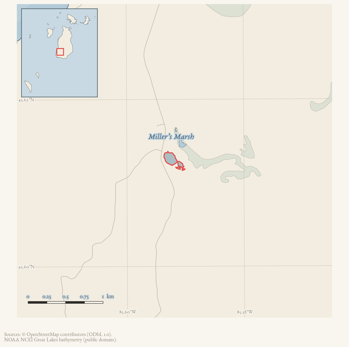
Millers Marsh is a small named water body on the west side of Beaver Island,
about 3.7 km (2.3 mi) west-northwest of Lake Geneserath and 16 km (10 mi) southwest of Saint James.1 GNIS classifies the feature as a “Lake” (feature 632348)
at 45.612659° N, 85.5922152° W, but local usage — the Beaver Island Master
Plan and decades of Beaver Beacon reporting alike — consistently calls it
a marsh or wetland rather than open water, and this article keeps the broad
WaterBody type pending resolution of that classification gap.2
3 The name commemorates Harrison “Tip” Miller, the island’s
fourth lighthouse keeper.1 The marsh sits within a 230-acre tract
that had been privately owned and faced development plans until the Little
Traverse Conservancy bought it in 1997 and resold it to Central Michigan
University, which closed the purchase on 31 March 1999 and now uses it as a
biological research area and public trail — though a 2015 newspaper account
instead attributes the same tract to the Conservancy, and a March 2000
Beacon item calls it state-owned, discrepancies this article records
rather than fully resolves.3456
Geography
The GNIS point for Millers Marsh sits at 45.612659° N, 85.5922152° W, on the “Beaver Island South” quadrangle, along West Side Drive.2 The project’s own OSM-based crosswalk finds a mapped wetland polygon of only 0.026979 km² (about 6.7 acres) at this location — the open-water and emergent-wetland core, not the larger surrounding tract — intersecting Freshwater Emergent Wetland classes (NWI PEM1F and PEM1C), lacustrine sand and gravel, and Detroit River Group bedrock; the crosswalk’s own reconstructed circa-1800 land-cover overlay for the same footprint is 98.9% “LAKE/RIVER.”7 That small figure is closer in order of magnitude to a 1976 Charlevoix County Planning Department lake survey, which lists “Miller’s Marsh, 16.5 acres” among Peaine Township’s named lakes (Round Lake 19, Barneys Lake 45, Egg Lake 19, Fox Lake 75, Greens Lake 62, Lake Geneserath 440).8 Both figures are far smaller than the 230 acres the 2023 Beaver Island Master Plan gives for “Miller’s Marsh” — but the Master Plan’s 230-acre figure describes a “wetland complex” and “Research Area” that Central Michigan University owns, not the open-water feature alone, and no source held here states the two figures’ precise relationship.3
Names
The 1978 History Map repeats the GNIS namesake tradition and calls Harrison “Tip” Miller the island’s fourth lighthouse keeper. A contemporary 1908 newspaper reprint independently places Miller at the Beaver Island light from 1863 to 1874 and in the Life-Saving Service from 1876. It does not number the keepers, however, so “fourth” remains a compiled ordinal whose answer may depend on whether acting and appointed keepers are counted.
GNIS records exactly one variant name for feature 632348: “Millar Marsh,” sourced to a USGS 1:62,500 topographic map.9 That is an orthographic spelling of “Miller’s/Millers Marsh” — the same possessive name with the vowel dropped — and not a documented former or different name, so it is retained here as an alternate spelling rather than a former name. Nothing among the sources held here — GNIS’s feature description, the Beacon reporting from 1960 to 1968, or the 2023 Master Plan — records any earlier or alternative name for this feature; there is no equivalent here of the Saint James Harbor / Beaver Harbor case, where a GNIS “variant” turned out to mask a genuinely superseded operative name.
Ownership and use
Central Michigan University owns the marsh and the wetland complex around it as part of roughly 478 acres it holds on the island, alongside the CMU Biological Station and Campground and the CMU Boat House on Paradise Bay.3 The Master Plan describes a public one-mile walking trail around the marsh with a picnic table and outhouses, and calls the site “a diverse ecosystem including a wetland dominated by sedges, turtles, [a] beaver lodge.”3 A 2023 Ch. 7 proposal in the same plan named 230 acres “at Millers Marsh (owned by Central Michigan University and kept protected as a Biological Research Area)” as one of two tracts selected for a proposed “Dark Sky Sanctuary Wildlife Research Area” on the island, alongside 9,195.5 acres of state Wildlife Research Area — a stated proposal in the 2023 plan, not a confirmed designation.3
A 2015 Charlevoix Courier article on the island’s Birding Trail instead lists “230-acre Miller’s Marsh” among “four Little Traverse Conservancy preserves,” alongside the 28-acre Little Sandy Bay, the 28-acre George and Althea Petritz Preserve, and the 112-acre Barney’s Lake.4 This conflicts with the Master Plan, which both states CMU ownership of Miller’s Marsh directly and separately lists the Conservancy’s own preserves — Barney’s Lake, Little Sand Bay, Conn’s Cove, Karl J. Erber, Stanhope Family, Sarah A. Martin, and George and Althea Petritz Preserves — without Miller’s Marsh among them.3
The Beacon’s own contemporary record resolves most, though not all, of this. In May 1998 it reported that the 230-acre tract, then privately owned and facing development plans, had been bought the previous year (1997) by the Little Traverse Conservancy of Harbor Springs, which agreed to resell it to Central Michigan University once CMU could raise the purchase price; by May 1998 the university’s drive, led by biological-station director James Gillingham, had raised more than $96,000 of a $138,000 goal.10 A May 1999 Beacon report, “CMUBS Purchases Miller’s Marsh,” states that CMU closed on the purchase on 31 March 1999, after its Board of Trustees approved the transaction that March.5 That account also gives a third acreage figure: the “marsh proper” is about 15 percent of the 230-acre tract, or roughly 34 acres — “the only true marsh found on Beaver Island” — closer in order of magnitude to the 1976 county survey’s 16.5 acres than to the OSM crosswalk’s 6.7-acre polygon, but not identical to either.5 Complicating this sale record, a March 2000 Beacon item instead describes “Miller’s Marsh, 210 acres, State-owned, assigned to the CMU Biological Station for student/faculty use and research” — an unresolved conflict within the Beacon’s own reporting, less than a year after its own account of a direct CMU purchase.6 Ownership is recorded here as contested: the 1998–99 purchase narrative is detailed, sourced to named officials, and consistent with the Master Plan’s later CMU-ownership statements, but neither the 2000 “State-owned” item nor the 2015 Courier’s Conservancy attribution is reconciled with it here.
Local reporting from the 1960s documents working and recreational uses around the marsh, predating its identification as a CMU research area in the sources held here. In June 1966, two mud turtles were seen digging nest holes in the road at the marsh, one nest holding eleven eggs.11 In December 1960, the Beaver Island Game Club marked a hunter trail running from east of the marsh to the north end of Lake Geneserath.12 In October 1961, the McClure Oil Company’s second well — between the sawmill and the marsh — drew its water supply from the marsh, about 2,000 feet away.13 In April 1968, Game Club members and the Michigan Department of Conservation carried out a controlled burn of about 35 acres just south of the marsh, intended to improve deer grazing.14 A January 1982 retrospective on island logging recalls that “one sawmill near Miller’s Marsh made croquet equipment in the 1940’s and 1950’s,” identifying the same mill’s later output.15 The marsh was not yet treated as protected research land in 1990: an August 1990 township board item reports that “Miller’s Marsh has been polluted with about 250 gallons of raw sewage,” with the DNR and Health Department recommending the material be disked or tilled underground.16 None of these accounts describes a surveyed boundary for the marsh or the burn area, and none identifies the well site’s later status.
The CMU Biological Station itself is documented as beginning field-biology coursework on the island in 1962 and, by a separate account, as “established” in 1966; Miller’s Marsh had already been used for that coursework, with the prior private owners’ permission, for decades before CMU’s 1999 purchase gave it formal ownership.
Open questions
- Can hydrology, parcel, or wetland inventories reconcile the GNIS “Lake” classification with the Master Plan’s marsh/wetland description?
- Does the March 2000 Beacon “State-owned” description reflect an error, a distinct parcel, or a since-corrected report, and does the Little Traverse Conservancy retain any interest in the tract today, as the 2015 Courier states but the Master Plan does not?
- How do the 1976 county survey’s 16.5-acre figure, the 1999 Beacon’s roughly 34-acre “marsh proper” figure, the crosswalk’s 6.7-acre OSM polygon, and the 210/230-acre whole-tract figures relate to one another and to a surveyed boundary?
- What is the present status of the CMU Biological Research Area and its public trail, and has the 2023 Master Plan’s Dark Sky Sanctuary proposal advanced?
- Can the 1968 controlled-burn area and the 1990 sewage spill be mapped separately from the marsh feature?
If you can answer any of these, or correct anything above, the archive wants to hear it — see Corrections.
See also
Footnotes
-
Charlevoix Courier, 2015, “Beaver Island businesses gearing up for fall tourism.” ↩ ↩2
-
Beaver Beacon, May 1999, “CMUBS Purchases Miller’s Marsh.” ↩ ↩2 ↩3
-
Project-generated named aquatic and wetland place crosswalk (2026); see Named aquatic and wetland places crosswalk, 2026. ↩
-
Charlevoix Courier, 1976, “There Are Plenty of Lakes.” ↩
-
USGS GNIS, All Names (national). ↩
-
Beaver Beacon, May 1998, “Miller’s Marsh” fundraising report. ↩
-
Beaver Beacon, June 1966, local nature report. ↩
-
Beaver Beacon, December 1960, Game Club report. ↩
-
Beaver Beacon, October 1961, “McClure Oil Company.” ↩
-
Beaver Beacon, April 1968, “Game News.” ↩
-
Beaver Beacon, January 1982, historical retrospective on island logging. ↩
-
Beaver Beacon, August 1990, township board minutes. ↩
The dated record
Sources
- GNIS feature 632348; feature class 'Lake'; map 'Beaver Island South'; bgn_authority 'Board Decision', bgn_date 1 January 1985.federal · gnis · gnis_names
- Feature 632348 description reads: 'On Beaver Island, 3.7 km (2.3 mi) WNW of Lake Geneserath and 16 km (10 mi) SW of Saint James.' History field names Harrison 'Tip' Miller, the island's fourth lighthouse keeper.federal · gnis · gnis_feature_descriptions
- The only variant-names row for feature 632348 is 'Millar Marsh' (feature_name_official: Variant), sourced to a USGS 1:62,500 topographic map. No former-name candidate is recorded; this is read as a spelling variant, not a superseded name.federal · gnis · gnis_variant_names
- Described in this archive: Beaver Island History Map, 1978 revision.Repeats the Harrison “Tip” Miller namesake and calls him the island's fourth lighthouse keeper. The namesake is independently repeated by GNIS; the ordinal remains a compiled claim pending the Lighthouse Service appointment register.
- Project-generated named aquatic and wetland place crosswalk (2026).Described in this archive: Named aquatic and wetland places crosswalk, 2026.Matches GNIS feature 632348 to an OSM-mapped wetland polygon of 0.026979 km² (about 6.7 acres) — the open-water/wetland core only, not the surrounding CMU-owned tract. Its 50 m context intersects Freshwater Emergent Wetland (NWI classes PEM1F, PEM1C), lacustrine sand and gravel (Quaternary geology), and Detroit River Group bedrock. Circa-1800 land cover for the same footprint is 98.9% 'LAKE/RIVER' with trace mixed-conifer-swamp and beech-sugar maple-hemlock forest. The crosswalk states plainly that an OSM polygon is a working research snapshot, not a legal or surveyed boundary. No public copy of this file is known; the archive holds one and can provide it on request.research · places · named_aquatic_wetland_place_crosswalk
- Read directly. Describes 'Miller's Marsh' as a small lake in a larger wetland complex owned by Central Michigan University, with a public CMU trail around it (Ch. 2). A recreation table gives '230 acres,' 'diverse ecosystem including a wetland dominated by sedges, turtles, beaver lodge, 1-mile Public walking trail, picnic table, outhouses,' with West Side Drive as the approximate location. Elsewhere states CMU owns approximately 478 acres on the island 'including the Miller's Marsh Research Area.' A separate Ch. 7 'Dark Sky Sanctuary' proposal names '230 acres of land at Millers Marsh (owned by Central Michigan University and kept protected as a Biological Research Area)' as one of two tracts the Dark Sky Project had selected for a proposed Dark Sky Sanctuary Wildlife Research Area — a 2023 proposal, not a stated designation in force.
- Charlevoix Courier, 1976, "There Are Plenty of Lakes."Reprints a Charlevoix County Planning Department Natural Resources Survey of county lakes by township. Under Peaine Township: 'Miller's Marsh, 16.5 acres' (alongside Round Lake 19, Barneys Lake 45, Egg Lake 19, Fox Lake 75, Greens Lake 62, Lake Geneserath 440). This 1976 county survey figure is far smaller than the Master Plan's 230-acre figure; the two appear to describe different things — the lake/marsh itself versus the larger CMU-owned tract that surrounds it — but no source held here states that reconciliation explicitly. No public copy of this file is known; the archive holds one and can provide it on request.data1 · beaver-island-archive · charlevoix · charlevoixcourie1976unse
- Charlevoix Courier, 2015, "Beaver Island businesses gearing up for fall tourism."Read directly. Lists the Beaver Island Birding Trail's 'four Little Traverse Conservancy preserves including the 28-acre Little Sandy Bay, 230-acre Miller's Marsh, 28-acre George and Althea Petritz Preserve and the 112-acre Barney's Lake.' This attributes the 230-acre Miller's Marsh tract to Little Traverse Conservancy ownership, which conflicts with the Master Plan's repeated, specific statement that the same 230-acre tract is CMU-owned. The Master Plan's own list of Little Traverse Conservancy preserves (Barney's Lake, Little Sand Bay, Conn's Cove, Karl J. Erber, Stanhope Family, Sarah A. Martin, and George and Althea Petritz Preserves) does not include Miller's Marsh. Recorded here as a contested ownership claim rather than resolved in the Courier's favor. No public copy of this file is known; the archive holds one and can provide it on request.data1 · beaver-island-archive · charlevoix · Charlevoix-Courier-2015
- Reports two mud turtles digging nests in the road at Miller’s Marsh and records eleven eggs in one nest.data1 · beaver-island-archive · beaver_beacon · 1966-06_Beaver-Beacon
- The held seven-page issue scan is paired with the OCR source and confirms the published notice or report; it does not expand the source-specific identity, event, or outcome claims.data1 · beaver-island-archive · scans · beaver_beacon · issues · 1966-06_Beaver-Beacon
- Reports a 35-acre controlled burn just south of Miller’s Marsh, carried out by Game Club members and the Conservation Department to improve deer grazing.data1 · beaver-island-archive · beaver_beacon · 1968-04_Beaver-Beacon
- The held six-page issue scan is paired with the OCR source and confirms the published notice or report; it does not expand the source-specific identity, event, or outcome claims.data1 · beaver-island-archive · scans · beaver_beacon · issues · 1968-04_Beaver-Beacon
- Describes a marked hunter trail running from east of Miller’s Marsh toward the north end of Lake Geneserath.data1 · beaver-island-archive · beaver_beacon · 1960-12_Beaver-Beacon
- The held five-page issue scan is paired with the OCR source and confirms the published notice or report; it does not expand the source-specific identity, event, or outcome claims.data1 · beaver-island-archive · scans · beaver_beacon · issues · 1960-12_Beaver-Beacon
- Places an oil well between the sawmill and Miller’s Marsh and says the marsh supplied water for the operation from about 2,000 feet away.data1 · beaver-island-archive · beaver_beacon · 1961-10_Beaver-Beacon
- The held five-page issue scan is paired with the OCR source and confirms the published notice or report; it does not expand the source-specific identity, event, or outcome claims.data1 · beaver-island-archive · scans · beaver_beacon · issues · 1961-10_Beaver-Beacon
- Reports that a 230-acre "privately-owned wetland" tract known as Miller's Marsh faced development plans; that Little Traverse Conservancy of Harbor Springs had bought it from its original owners "last year" (1997) and agreed to sell it to CMU if CMU could raise the money; that CMU had raised over $96,000 of a $138,000 goal by May 1998, led by biological-station director James Gillingham; that the CMU Biological Station was "established in 1966"; and that more than 500 turtles in the marsh had been marked for research. The holding institution's portal restricts automated access; the archive holds a copy of this issue and can provide it on request.data1 · beaver-island-archive · beaver_beacon · 1998-05_Beaver-Beacon
- The held issue scan is paired with the canonical OCR source and confirms the Miller's Marsh fundraising report.data1 · beaver-island-archive · scans · beaver_beacon · issues · 1998-05_Beaver-Beacon
- Reports that CMU closed on the purchase of the 230-acre Miller's Marsh property on March 31, 1999, after the Little Traverse Conservancy had purchased it in spring 1997 to hold pending CMU fundraising; states the "marsh proper" is about 15% of the 230 acres (roughly 34 acres) and "the only true marsh found on Beaver Island"; and says the CMU Biological Station first offered field-biology courses using the site in 1962. The holding institution's portal restricts automated access; the archive holds a copy of this issue and can provide it on request.data1 · beaver-island-archive · beaver_beacon · 1999-05_Beaver-Beacon
- A short item gives "Miller's Marsh, 210 acres, State-owned, assigned to the CMU Biological Station for student/faculty use and research" -- describing the tract as state property less than a year after the Beacon's own report of a direct CMU purchase, an unresolved conflict within the held Beacon record itself. The holding institution's portal restricts automated access; the archive holds a copy of this issue and can provide it on request.data1 · beaver-island-archive · beaver_beacon · 2000-03_Beaver-Beacon
- States that "one sawmill near Miller's Marsh made croquet equipment in the 1940's and 1950's," part of a broader account of the island's early-20th-century logging industry. The holding institution's portal restricts automated access; the archive holds a copy of this issue and can provide it on request.data1 · beaver-island-archive · beaver_beacon · 1982-01_Beaver-Beacon
- Reports that "Miller's Marsh has been polluted with about 250 gallons of raw sewage," with the DNR and Health Department notified and recommending the material be disked or tilled underground -- evidence the site was neither state nor CMU research land in any protective sense as of 1990. The holding institution's portal restricts automated access; the archive holds a copy of this issue and can provide it on request.data1 · beaver-island-archive · beaver_beacon · 1990-08_Beaver-Beacon
Added 28 July 2026 · revised 4 August 2026. Recent changes
Cite this article
Beaver Island Archive, “Miller’s Marsh”, https://beaverislandarchive.org/places/millers-marsh/, accessed [date], citing U.S. Geological Survey, Geographic Names Information System, Domestic Names (Michigan), retrieved 2026-07-28. (and 21 further sources listed on the page).
Last revised 2026-08-04. Fill in [date] with the date you read it — this page is static and cannot know that.