

- Dates
- 1845 – 2026
- Eras
- Glo eraModern era
- Concepts
- soilsgeologyforeststreesvegetationplantswetlandshydrologyanimalsfishwildlifebirdsconservationcartographyenvironment
- Within
- Beaver Island archipelago
Summary
This matrix is the archipelago-wide comparison layer that the individual ecology indexes were missing. It places seven island records side by side and retains the source-specific measures for tree and woody-vegetation evidence, plant evidence, MNFI natural-community occurrences, animals and birds, aquatic fauna and fisheries, DNR forest stands, NLCD canopy, NLCD land cover, SSURGO soils, and physical geology.
The matrix does not pretend that these sources measure the same thing. A tree row is an evidence match, an MNFI record is a named occurrence, a DNR stand is an inventory polygon, a canopy value is a 30 m remote-sensing summary, and a soil or geology value is mapped regional context. The output makes those different units easier to compare while retaining their labels and limits.
Seven-island comparison
| Island | Historical GLO rows | Tree/woody evidence rows | Plant evidence rows | MNFI occurrences | Animal/bird records | Aquatic/fisheries rows | Invasive/stewardship rows | NWI features | NWI km² | EGLE hydric km² | Named water/wetland anchors | DNR stands | 2023 mean canopy | SSURGO map units |
|---|---|---|---|---|---|---|---|---|---|---|---|---|---|---|
| Beaver Island | 21 | 1,634 | 1,410 | 17 | 48 | 5 | 51 | 318 | 47.824 | 64.536 | 16 | 424 | 65.50% | 33 |
| Garden Island | 8 | 88 | 256 | 12 | 11 | 7 | 12 | 52 | 20.201 | 4.037 | 1 | 0 | 59.97% | 7 |
| High Island | 3 | 51 | 229 | 8 | 21 | 5 | 8 | 22 | 1.058 | 6.523 | 1 | 0 | 70.56% | 13 |
| Hog Island | 4 | 48 | 155 | 6 | 10 | 2 | 7 | 58 | 3.674 | 1.832 | 0 | 0 | 60.82% | 6 |
| Whiskey Island | 2 | 4 | 3 | 0 | 4 | 2 | 0 | — | — | — | 0 | 0 | 39.99% | 2 |
| North Fox Island | 4 | 22 | 61 | 0 | 5 | 2 | 2 | — | — | — | 0 | 0 | 69.77% | 12 |
| South Fox Island | 1 | 4 | 82 | 0 | 13 | 0 | 4 | — | — | — | 0 | 0 | 64.43% | 13 |
These values are navigation signals, not rankings. Beaver has much larger tree and plant counts partly because the DNR public-forest comments and MNFI occurrence descriptions are concentrated there. Garden, High, and Hog have substantial MNFI occurrence coverage. Fox now also has structured mapped-dune vegetation entries, while Whiskey has only broad cover-type labels; neither should be read as equivalent to a complete plant inventory or current DNR stand coverage.
What the connectivity makes visible
Forest structure and named trees
The tree index contributes exact-island GLO, MNFI, guide, and DNR-comment evidence, with the largest source concentration on Beaver. The current canopy layer extends quantitative structure to all seven islands, including North and South Fox. The DNR inventory adds stand and covertype detail only for the returned Beaver frame. A high canopy value therefore cannot be translated into a particular cedar, pine, spruce, maple, oak, or beech community without the source-specific tree and natural-community evidence.
Plants, soils, and natural communities
The MNFI occurrence matrix connects plants and tree taxa to named bogs, fens, marshes, dunes, boreal forests, northern forests, and conifer swamps on four islands. The outer-island mapped-dune indexes add structured vegetation and tree-type entries for Hog, North Fox, and South Fox, while Whiskey contributes only broad cover types. The SSURGO and physical-geology sections extend the comparison to all seven islands, but only at island context scale. The matrix keeps the useful question—where do source records describe similar trees, plants, substrates, and water regimes?—separate from the stronger and usually unsupported claim that a particular soil polygon overlaps a particular occurrence.
Historical GLO ecology
The historical GLO layer adds 43 exact-island rows from the 1845–1849 survey sequence to the matrix. These are not a second modern habitat survey: they are page-bounded surveyor descriptions that put soil, shore material, water, tree names, vegetation, fire, windfall, timber cutting, fishery use, and occasional bird language on a dated historical frame. Beaver contributes 21 rows; Garden 8; Hog 4; North Fox 4; High 3; Whiskey 2; and South Fox 1. The 1942 Shoe and Pismire records are kept in the same domain but remain outside the exact seven-island counts.
This makes historical change queryable without pretending that a survey route is a forest stand or a page description is an ecological inventory. The source records retain the handwritten or typed survey date, page image, township and range, source wording, and explicit limits. Group-scoped Garden/Hog language, small-island observations, and the 1942 form are not split or normalized into unsupported modern island assignments.
Invasive species and stewardship
The stewardship layer adds 84 exact-island source rows while preserving five different evidence classes. Beaver’s 51 rows combine the 31 source-defined 2024 invasive-plant list entries, seven GEI survey and planning records, twelve MNFI 2017 occurrence stewardship records, and one MNFI 2019 Beaver case-study record. Garden, High, and Hog retain MNFI occurrence stewardship evidence; North and South Fox retain current mapped-dune invasive or disturbance signals. Whiskey has no exact-island row in this source bundle. Seven additional MNFI 2019 action-framework records remain regional or unassigned.
These rows connect invasive plants to forests, dunes, marshes, fens, shorelines, soil and hydrology concerns, rare-species safeguards, and colonial-waterbird planning. They must not be read as a current invasive distribution map: a source-defined list is not a point occurrence, a stewardship recommendation is not a treatment result, and the unavailable GEI appendices are not reconstructed from downstream accounts.
Wetlands and hydrology
The wetland/hydrology domain adds direct mapped context where the held sources support it. The NWI and EGLE hydric-soil summaries cover Beaver, Garden, High, and Hog in the held environmental crosswalk; Beaver has 318 NWI features over 47.824 km² and 207 EGLE hydric-soil features over 64.536 km², while the smaller islands have their own asymmetric values. The named-place crosswalk adds 18 exact-contained aquatic or wetland anchors within the seven-island frame, including 16 on Beaver and one each on Garden and High. Point features that are only nearest to an island are not assigned to it.
These are map-context joins, not wetland delineations for parcels or species. They are useful for reading fens, marshes, swamps, ponds, lakes, streams, and hydric soils beside the forest, plant, invasive, bird, and aquatic-fauna records, while preserving missing NWI/EGLE context for Whiskey and both Fox Islands as a source-coverage gap.
Animals and birds
The wildlife/bird layer preserves species, distribution, survey, management, and observation records across the archipelago. It can be read alongside forest, wetland, canopy, soil, and geology context, but the matrix does not infer habitat suitability or occupancy from those layers. An island with zero MNFI occurrence records or zero DNR stands is not an island with zero animals, birds, trees, or natural communities.
Fox Islands and source asymmetry
North and South Fox are intentionally present as full rows rather than being lost inside a Beaver-centered summary. Their rows show the current canopy and soil/geology frames, sparse tree evidence, source-declared wildlife/bird records, and the absence of returned public DNR stands and MNFI occurrence records in the held indexes. Those asymmetries identify research priorities; they do not establish ecological absence. The same rule applies to Whiskey.
Aquatic fauna and fisheries
The aquatic layer adds 23 exact-island rows to this seven-island frame. Beaver has source-defined pondsnail and lake-trout/whitefish-management records; Garden and Hog have wetland-fauna signals tied to coastal fens, marl pools, crayfish burrows, and Hine’s emerald dragonfly; High has both aquatic-fauna and GLO fish-shanty evidence; and Whiskey and North Fox retain page-bounded GLO fishery-use observations. South Fox has no exact-island row in this particular index. The remaining 14 rows concern Ojibwa, Trout, Gull, and Gull Island area scopes and are intentionally not folded into the seven named islands.
The distinction matters: a crayfish burrow or pondsnail list entry is aquatic fauna evidence; a GLO fish shanty or fishing village is historical human-use evidence; and a federal egg-planning or fry-distribution table is agency activity or planning evidence. None is by itself a current fish inventory, catch series, stocking-site polygon, or population estimate.
Method and limits
The generator joins existing records by exact island names or consumes an existing island-level summary. It does not perform a new spatial overlay or assign a soil, geology, canopy, land-cover, or DNR polygon to an MNFI occurrence, wildlife observation, tree mention, or parcel. Group labels such as “Garden and Hog Islands” remain group-scoped in the tree index instead of being split into two records.
Evidence-row counts are not counts of individuals or abundance. Wildlife and bird records have source-specific survey and distribution meanings. Aquatic- fauna rows, GLO fishery-use observations, and federal fish-management records are distinct evidence classes; fishery activity is not an aquatic occurrence, and planning or stocking tables are not proof of a local release, collection station, abundance, or current occupancy. NLCD canopy and land-cover values are remote-sensing summaries. SSURGO and physical geology categories are regional map context. The DNR inventory is asymmetric and public-inventory based. The underlying source indexes, source excerpts, geometries, rasters, and provenance files should be consulted before making a site-level claim.
See also
- Tree and woody vegetation evidence index for the Beaver archipelago, 2026
- Plant and vegetation evidence index for the Beaver archipelago, 2026
- MNFI natural-community ecological connectivity matrix, 2017
- Wildlife and habitat evidence index for the Beaver archipelago, 2026
- Aquatic fauna and fisheries evidence index for the Beaver archipelago, 2026
- Named aquatic and wetland places crosswalk, 2026
- Visually verified GLO survey observations of archipelago soils, terrain, and trees, 1845–1849
- Visually verified GLO modern island ecology observations, 1942
- MNFI Great Lakes island invasive-species action and ecological-resilience framework, 2019
- Beaver Island Archipelago wildlife and bird species evidence index, 2017–2024
- Michigan DNR public forest inventory stand cover types, 2026 snapshot
- NLCD tree-canopy percentage across the seven islands, 2021 and 2023
- Annual NLCD land cover across the seven-island archipelago, 2021 and 2025
- USDA wildlife-habitat ratings connected to island-scale SSURGO map units
- Archipelago physical geology and hydrogeologic context crosswalk, 2026
- Geology and landforms
- Forest types and tree history
- Wetlands, inland waters, and hydrology
- Wildlife and bird life
- Invasive species and ecological stewardship
Sources
- Project-generated seven-island ecology connectivity matrix (2026).Contains one comparison record for Beaver, Garden, High, Hog, Whiskey, North Fox, and South Fox Islands. It joins existing island-level summaries and exact island-name evidence; it does not create new polygon overlays. No public copy of this file is known; the archive holds one and can provide it on request.research · island_farming · crosswalks · archipelago_ecology_connectivity_matrix_2026
- Project-generated tree and woody vegetation evidence index (2026).Supplies source-separated historical GLO, MNFI, guide, and DNR stand-comment tree evidence. Group-scoped names are retained and not split into unsupported island assignments. No public copy of this file is known; the archive holds one and can provide it on request.research · island_farming · indices · tree_woody_vegetation_evidence_index
- Project-generated plant and vegetation evidence index (2026).Supplies source-separated plant-list and occurrence or stand-comment evidence, with its four-island and list-scope limits preserved. No public copy of this file is known; the archive holds one and can provide it on request.research · island_farming · indices · plant_vegetation_evidence_index
- Project-generated MNFI natural-community ecological connectivity matrix (2026).Supplies occurrence-level soil/hydrology, tree, plant, and wildlife context for 43 records on Beaver, Garden, High, and Hog. No public copy of this file is known; the archive holds one and can provide it on request.research · island_farming · crosswalks · mnfi_natural_community_connectivity_matrix
- Project-generated archipelago wildlife and bird species evidence index (2017–2024).Supplies source-declared animal and bird distribution, survey, and observation records across the seven-island frame. No public copy of this file is known; the archive holds one and can provide it on request.research · wildlife · indices · archipelago_wildlife_bird_evidence_2017_2024
- Project-generated wildlife and habitat evidence index (2026).Provides additional habitat-signal context while retaining island-level rather than occurrence-level joins. No public copy of this file is known; the archive holds one and can provide it on request.research · wildlife · indices · wildlife_habitat_evidence_index
- Project-generated aquatic fauna and fisheries evidence index for the Beaver archipelago (2026).Adds 37 source-separated wetland-fauna, GLO fishery-use, and federal fish-management rows; 23 have exact names in the seven-island frame and 14 remain on smaller or differently scoped islands. No public copy of this file is known; the archive holds one and can provide it on request.research · wildlife · indices · aquatic_fauna_fisheries_evidence_index_2026
- Project-generated named aquatic and wetland place crosswalk (2026).Adds exact-contained named water, wetland, bay, beach, and related anchors with NWI/SSURGO/geology context where polygon geometry exists; point features and nearest-island relationships remain separate. No public copy of this file is known; the archive holds one and can provide it on request.research · places · named_aquatic_wetland_place_crosswalk
- Project-generated wildlife and habitat island environmental context (2026).Supplies island-level NWI wetland and EGLE hydric-soil feature counts and areas for the four islands covered by that held context; missing Fox/Whiskey values are retained as coverage gaps. No public copy of this file is known; the archive holds one and can provide it on request.research · wildlife · indices · wildlife_habitat_evidence_index
- Adds 57 page-bounded historical observations of soil, shore, water, vegetation, tree names, disturbance, and limited animal/bird language; exact island rows remain separate from group and small-island scopes. The holder's public portal is searchable but does not link this record directly; the archive holds a copy of the file and can provide it on request.research · land_cover · crosswalks · glo_ecology_crosswalk_1845_1849
- Adds four separately dated Shoe and Pismire survey descriptions, retained outside the seven-island exact-name summary. The holder's public portal is searchable but does not link this record directly; the archive holds a copy of the file and can provide it on request.research · land_cover · crosswalks · glo_modern_ecology_1942
- Project-generated Beaver Island GEI invasive-species survey evidence crosswalk (2017).Adds seven Beaver Island survey, target-list, treatment-priority, and retrieval-gap records without inventing the unavailable GEI occurrence or treatment geometry. No public copy of this file is known; the archive holds one and can provide it on request.research · wildlife · indices · gei_beaver_invasive_survey_2017
- Project-generated MNFI island invasive-action evidence index (2019).Adds one exact Beaver case-study row and retains seven regional or unassigned action-framework rows outside the island summaries. No public copy of this file is known; the archive holds one and can provide it on request.research · wildlife · indices · mnfi_island_invasive_action_2019
- Project-generated MNFI soil, vegetation, and wildlife crosswalk (2017).Supplies 38 exact-island occurrence records whose stewardship excerpts explicitly mention invasive plants, non-native species, or invasive monitoring. No public copy of this file is known; the archive holds one and can provide it on request.research · island_farming · crosswalks · mnfi_soil_vegetation_wildlife_crosswalk
- Project-generated Michigan DNR public forest inventory island-stand crosswalk (2026-08-03).Supplies clipped stand counts and cover-group summaries. The query returned 424 Beaver stands and zero returned stands for the other six island frames; zeroes are coverage results, not forest absence. No public copy of this file is known; the archive holds one and can provide it on request.research · forest_inventory · indices · mdnr_forest_inventory_island_stands_2026-08-03
- Project-generated NLCD tree-canopy island extraction (2021 and 2023).Supplies exact-island 30 m canopy-percentage summaries for all seven islands. No public copy of this file is known; the archive holds one and can provide it on request.research · tree_canopy · indices · nlcd_tree_canopy_island_2021_2023_2026-08-02
- Project-generated annual NLCD island land-cover extraction (2021 and 2025).Supplies island-level forest, wetland, barren, and water context; it is not a species or habitat-suitability layer. No public copy of this file is known; the archive holds one and can provide it on request.research · land_cover · crosswalks · annual_nlcd_island_ecology_crosswalk_2021_2025_2026-08-02
- Project-generated USDA wildlife-rating to island-scale SSURGO crosswalk.Supplies map-unit and component context with exact-symbol, candidate, and unmatched tiers preserved. No public copy of this file is known; the archive holds one and can provide it on request.soils · indices · usda_ssurgo_wildlife_island_crosswalk
- Project-generated archipelago physical-geology and hydrogeology context crosswalk.Supplies island-level intersections with regional aquifer, SGMC, bedrock, fault, and glacial-boundary layers; categories are not site or exposure determinations. No public copy of this file is known; the archive holds one and can provide it on request.geology · crosswalks · archipelago_physical_geology_context
- Generator and input checksums for the ecology connectivity matrix.Preserves the input-file SHA-256 values and generation metadata. No public copy of this file is known; the archive holds one and can provide it on request.research · island_farming · crosswalks · archipelago_ecology_connectivity_matrix_2026.provenance
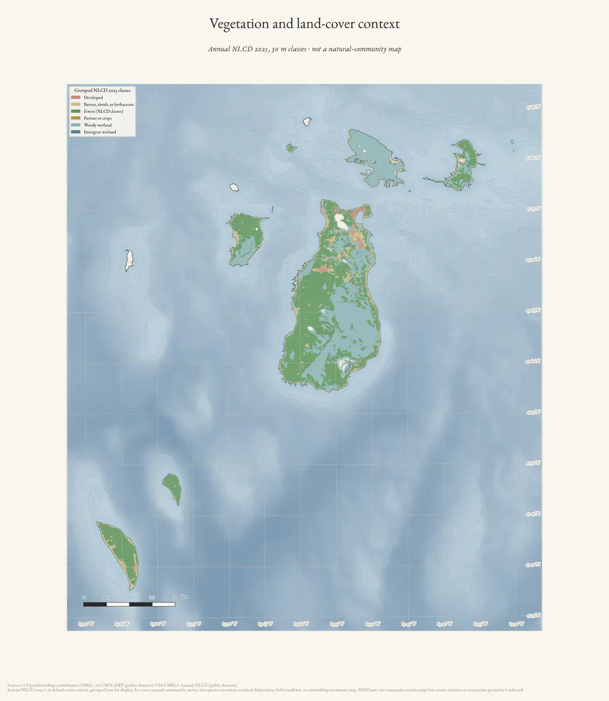
- Beaver Island Archive, *Vegetation and land-cover context of the Beaver Island archipelago* — plate drawn by this project. CC BY 4.0 for the drawing; underlying data under its own terms (see credit)Grouped land-cover context at 30 m for the seven islands whose connectivity this matrix scores. Cover types only; not an MNFI natural-community map. Credit: Drawn from the archive's own data in EPSG:3078. Map data © OpenStreetMap contributors (ODbL 1.0); USGS MRLC Annual NLCD and USGS 3DEP (public domain). No public copy of this file is known; the archive holds one and can provide it on request.output · maps · ecology · archipelago-ecology
Added 3 August 2026. Recent changes
Cite this article
Beaver Island Archive, “Seven-island ecology connectivity matrix, 2026”, https://beaverislandarchive.org/documents/archipelago-ecology-connectivity-matrix-2026/, accessed [date], citing Project-generated seven-island ecology connectivity matrix (2026). (and 20 further sources listed on the page).
Last revised 2026-08-03. Fill in [date] with the date you read it — this page is static and cannot know that.
BibTeX for “Seven-island ecology connectivity matrix, 2026”RIS for “Seven-island ecology connectivity matrix, 2026”