

- Dates
- 1999 – 2026
- Eras
- Modern era
- Concepts
- environmentconservationforestswetlandsgeologysoilsheritage
- Within
- Beaver Island archipelago · North Fox Island · South Fox Island · Whiskey Island · Hog Island · Garden Island · High Island
What this index does
The outer-island record is not one homogeneous survey. It is a connected set of evidence layers with different dates, methods, and geographic footprints. The generated index retains 68 source records from eight existing indexes and groups them by the island name reported by each source. The nested source record remains available for exact wording, pages, occurrence identifiers, species lists, and evidence limits.
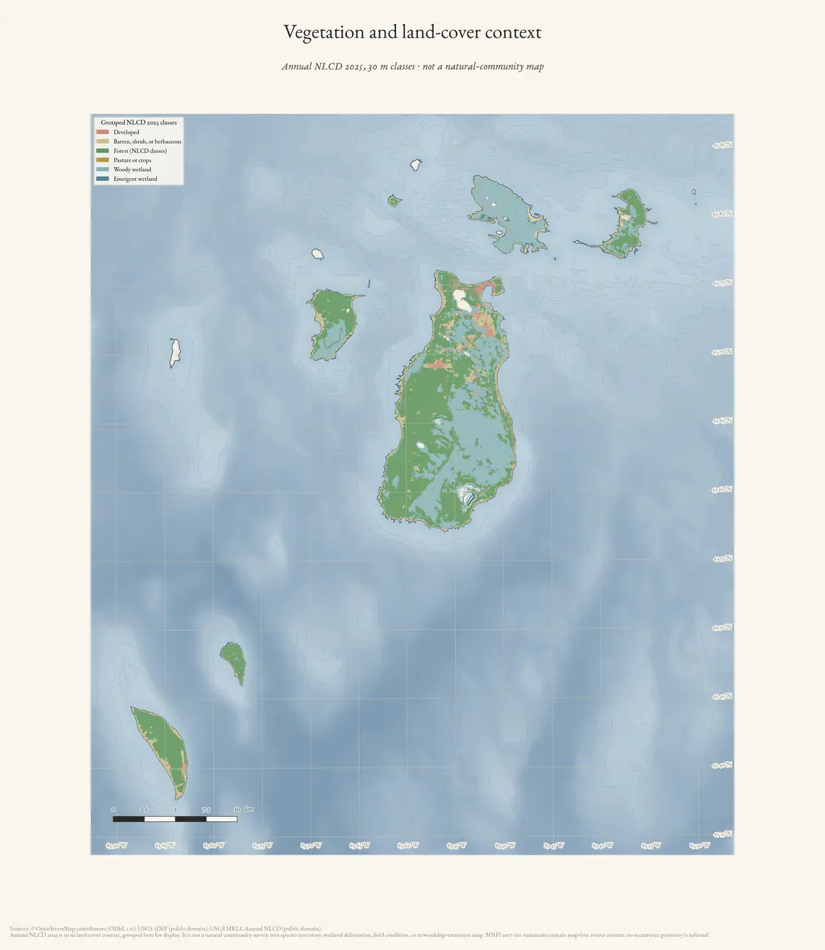
This makes the ecology corpus broader without flattening its uncertainties. The 2015 MNFI addendum, the 2019 Fox prioritization, the EGLE mapped-dune reports, the Whiskey cormorant study, and the 1999/2002 MNFI records can now be searched together while remaining visibly different kinds of evidence.
North Fox and South Fox
North Fox has two complementary layers. The 2019 MNFI prioritization preserves three historical natural-community occurrences—boreal forest, mesic northern forest, and northern hardwood swamp—with old survey dates, plus candidate open-dune and sand-and-gravel-beach targets. The later EGLE material records 2021 MNFI survey descriptions in mapped dune complexes 76 and 77. MDC 76 is a 105.4-acre southwestern parabolic barrier-dune complex with a maximum mapped height of 153.2 feet and four documented natural-community occurrences: open dunes, boreal forest, mesic northern forest, and sand-and-gravel beach. The report counts two rare-plant and two rare-animal element occurrences there.
The occurrence descriptions connect active foredune, blowouts, burial and abrasion to stabilized mesic forest, boreal forest, and shoreline habitat. The tree record includes northern white-cedar, paper birch, balsam fir, aspen, sugar maple, green ash, red oak, basswood, beech, maple, ironwood, and Canada yew. A sugar maple was estimated at 236 years and a mature cedar at more than 300 years in the mesic forest; several boreal-forest cedars were estimated at more than 200 years. These are surveyed-stand age observations, not an islandwide age distribution.
South Fox is the strongest outer-island landscape connection currently held. EGLE mapped-dune complex 75 encompasses the island-scale dune-related topography: high west-facing and lower east-facing parabolic dunes, beach ridges, perched dunes, bluffs, and interdunal depressions. The overview is approximately 3,430 acres with 11.6 miles of shore and a maximum mapped height of 365.9 feet. It preserves eight 2021-surveyed natural-community occurrences: three open dunes, an interdunal wetland, boreal forest, mesic northern forest, sand-and-gravel beach, and clay bluff. The report counts eight rare-plant and seven rare-animal element occurrences.
South Fox’s forest and wetland records show why the Fox Islands belong in the same ecological conversation as Beaver, Garden, High, and Hog. Boreal forest on steep bluffs and dunes is dominated by uneven-aged northern white-cedar, with old trees, blowout edges, windthrow, erosion, and coarse woody debris. Mesic northern forest includes mature and old-growth sugar maple, beech, cedar, paper birch, basswood, red oak, and white ash. The interdunal wetland record documents standing water, calcareous indicators, rushes, sedges, beak-rush, native reed, toads, dragonflies, and feeding habitat for migrating shorebirds, waterfowl, and songbirds. These are occurrence-level descriptions, not a complete flora, fauna, or wetland-boundary inventory.
Garden, High, and Hog
The 2015 Garden/High MNFI addendum supplies detail that the newer broad raster layers cannot: shallow alkaline loams and loamy organics over limestone cobble in Garden’s boreal forest; alkaline sands and gravelly sands over acidic organic layers in High’s boreal forest; acidic sands in High’s dry-mesic forest; and old sugar-maple, yellow-birch, hemlock, oak, and cedar structure in High’s Nezewabegon Forest. It also adds 2015 bat-acoustic detections, rare invertebrates, mollusks, incidental fauna, and community-priority information. The source is a targeted addendum, not a complete inventory.
Hog connects the older MNFI wetland record to the newer mapped-dune layer. The 1999 Baldimore Bay observation names Great Lakes marsh, northern fen, interdunal wetlands, and swamp forest, with northern white-cedar and emergent marsh vegetation under unusually low water. EGLE MDC 101 covers a smaller northwest wooded dune-and-swale and shoreline setting, with Great Lakes marsh, limestone cobble shore, and mesic northern forest. The mesic-forest description includes red oak, white pine, red maple, white ash, basswood, cedar, paper birch, and mature-to-old-growth trees estimated at roughly 146–203 years. Only part of the larger occurrences lies inside the mapped complex.
Whiskey Island and birds
Whiskey’s evidence is structurally different. The 2017 MDNR management plan provides a broad cover-type baseline—mixed conifer, balsam fir, and aspen—plus a dated natural-heritage survey gap, colonial-waterbird habitat, and bald-eagle nesting context. The separate 2010 peer-reviewed cormorant study gives direct single-season evidence: early and late counts recorded 332 and 107 nests, respectively, with both ground and tree nests, and the study modeled chick survival and prey consumption. Those modeled values should not be converted into a current colony trend or islandwide bird inventory.
The 1999 MNFI report provides a different kind of bird evidence: standardized survey-period comparisons among Beaver, Garden, and Bois Blanc, targeted species work, and habitat-linked observations. The 2002 synthesis explains how natural-feature occurrences were digitized and used to define significant biodiversity areas. Together, these older records document the historical methodological bridge between field observations and map-based conservation planning; they do not replace current surveys.
Small-island historical ecology layer
The modern outer-island sources do not cover every small island in the same way. The visually verified GLO crosswalk supplies a separate historical layer for several of them:
| Island and source date | Substrate and landform | Vegetation or fauna signal | Human-use or disturbance signal |
|---|---|---|---|
| Hat Island, 1849 | Nearly level gravel and small stone, about six feet high, with broad boat-landing access | Brushy cedar growth about 10–30 feet high; a nearby stone islet is described as covered with gulls | Part of the cedar growth had burned |
| Ojibwa Island, 1849 | Lake-formed stone ridges, sandy/stony soil only inches to about a foot deep, gravelly and sandy beaches | Aspen, fir, cedar, and white birch in the burned-over descriptions | Most timber was described as killed and fallen after burning |
| Trout Island, 1849 | Drifted-sand hills and a higher timbered hill; a low portion had thin soil, wet/swampy ground, and stone/gravel beach | Sugar, ironwood, fir, birch, hazel, cedar, spruce, pine, and short conifer growth | Fish shanties and wigwam frames are page-bounded shoreline-use evidence |
| Gull Island, 1849 | Low sandy and stony island with shallow water, a grass-and-gooseberry depression, and a small pond behind a stone/gravel ridge | Short sugar, cedar, fir, white birch, hazel, ground hemlock, and white pine | A fisherman’s shanty, 15 fish houses, and a bounded fishing-community estimate are recorded |
| Shoe Island, 1942 | Low gravel-and-boulder formation with gravelly shore and shallow-water setting | Sparse weeds, grass, and small willows; gull nesting/resting use is explicitly recorded | No improvements or available timber are reported |
| Pismire Island, 1942 | Gravel formation with considerable humus, gravelly/brushy shore, and mostly upland ground | Dead cedar grove, small ash and willow, grass and weeds; ducks and gulls are described as nesting/resting users | A cedar and two tamaracks served as bearing trees on a burned-over flat |
These records are line- and page-bounded observations, not small-island inventories. The 1942 typed pages are deliberately not merged into the 1845–1849 handwritten layer: they have a different survey form, date, and observation vocabulary. Neither layer supplies a current wetland delineation, bird census, species-abundance estimate, or inferred habitat polygon. Their value is comparative: they keep small islands visible in the archipelago’s soil–shore–vegetation–wildlife history even where modern survey coverage is thin.
Coverage and map limits
The index’s coverage matrix is deliberately explicit:
- Beaver, Garden, High, and Hog have the richest combination of modern MNFI occurrence evidence and older targeted records, with Garden and High also receiving the 2015 detailed addendum.
- North Fox and South Fox now have the 2019 historical-prioritization layer plus 2021-surveyed EGLE mapped-dune descriptions; South Fox’s mapped complex is island-scale, while North Fox’s two complexes are not a complete island inventory.
- Whiskey has direct bird-study evidence and management context but still has a dated natural-heritage survey gap.
- Bois Blanc and other islands appear as legacy comparison records in the 1999/2002 sources and should not be silently treated as part of the seven named Beaver-archipelago islands.
Representative occurrence points in the EGLE source indexes are retained as representative points, not natural-community boundaries. Candidate polygons from the 2019 prioritization are not confirmed occurrences. Island-level SSURGO, geology, NLCD, canopy, and GBIF summaries are contextual joins only. Missing records, zero public observations, missing coordinates, and source survey gaps are coverage results—not evidence that a species, forest type, wetland, or animal is absent.
The next high-value expansion is to seek authorized MNFI/MiFI occurrence geometry and source-safe survey tables for the Fox and Whiskey islands, then reconcile occurrence IDs and survey dates without replacing the source-bounded records preserved here.
Sources
- Project-generated outer-island and legacy ecology evidence index (2026).Normalizes 68 records from eight existing source indexes, preserves each nested source record, groups records by reported island, and adds a coverage matrix without merging source methods or inferring biological absence. No public copy of this file is known; the archive holds one and can provide it on request.research · wildlife · indices · outer_island_ecology_evidence_index
- Project-generated index builder and provenance sidecar.Rebuilds the JSON index and records SHA-256 hashes for all eight ecology inputs and the linked island-habitat context. No public copy of this file is known; the archive holds one and can provide it on request.scripts · build_outer_island_ecology_evidence_index
- MNFI Garden and High Island biodiversity, habitat, and acoustic surveys (2015 field season; Report 2016-04).Described in this archive: MNFI Garden and High Island biodiversity, habitat, and acoustic surveys, 2015.Adds forest/soil/tree measurements, rare invertebrates, mollusks, incidental fauna, and eight acoustic-bat records. No public copy of this file is known; the archive holds one and can provide it on request.research · wildlife · indices · mnfi_garden_high_2015_biodiversity_index
- MNFI Fox Island natural-community survey prioritization (2019).Described in this archive: MNFI Fox Island natural-community survey prioritization, 2019.Preserves North and South Fox historical EOs, candidate targets, survey-age logic, and the dated data-gap statement. No public copy of this file is known; the archive holds one and can provide it on request.research · wildlife · indices · mnfi_fox_island_survey_prioritization_2019
- EGLE North Fox Island mapped-dune, forest, vegetation, and wildlife evidence (2026 report using 2021 MNFI surveys).Described in this archive: North Fox Island mapped-dune, forest, vegetation, and wildlife evidence.Adds four natural-community occurrence records and two mapped-dune complex overviews; representative points are not occurrence boundaries. No public copy of this file is known; the archive holds one and can provide it on request.research · wildlife · indices · north_fox_mapped_dune_ecology_2026
- EGLE South Fox Island mapped-dune, forest, vegetation, wetland, and wildlife evidence (2026 report using 2021 MNFI surveys).Described in this archive: South Fox Island mapped-dune, forest, vegetation, wetland, and wildlife evidence.Adds eight natural-community occurrence records within the island-scale MDC 75 and preserves rare-element counts and survey limits. No public copy of this file is known; the archive holds one and can provide it on request.research · wildlife · indices · south_fox_mapped_dune_ecology_2026
- EGLE Hog Island mapped-dune, forest, shoreline, vegetation, and wildlife evidence (2026 report using 2015 and 2017 MNFI occurrence information).Described in this archive: Hog Island mapped-dune, forest, shoreline, vegetation, and wildlife evidence.Adds the northwest MDC 101 context and two partially overlapping natural-community occurrences; it is not a complete Hog Island inventory. No public copy of this file is known; the archive holds one and can provide it on request.research · wildlife · indices · hog_island_mapped_dune_ecology_2026
- Whiskey Island ecology, wildlife context, and 2010 cormorant study evidence.Described in this archive: Whiskey Island ecology, wildlife context, and cormorant study evidence.Keeps the 2017 management baseline, dated distribution-table context, and direct 2010 cormorant field-study records separate. No public copy of this file is known; the archive holds one and can provide it on request.research · wildlife · indices · whiskey_island_ecology_2010_2017
- MNFI Great Lakes Islands 1999 progress report crosswalk.Described in this archive: MNFI Great Lakes Islands 1999 progress report crosswalk.Adds targeted bird, aquatic, plant, invertebrate, and natural-community evidence for Beaver, Garden, Hog, and Bois Blanc. No public copy of this file is known; the archive holds one and can provide it on request.research · wildlife · indices · mnfi_great_lakes_islands_1999_inventory_index
- MNFI Great Lakes Islands 1998–2002 final inventory synthesis.Described in this archive: MNFI Great Lakes Islands 1998–2002 final inventory synthesis.Adds project-wide occurrence totals, significant-biodiversity-area context, GIS workflow, and legacy comparison-island records. No public copy of this file is known; the archive holds one and can provide it on request.research · wildlife · indices · mnfi_great_lakes_islands_2002_final_synthesis_index
- Project-generated island-level habitat context carried from the wildlife and habitat evidence index (2026).Provides NLCD, SSURGO, physical-geology, held environmental-layer, and GBIF summaries as island-level context only. No public copy of this file is known; the archive holds one and can provide it on request.research · wildlife · indices · wildlife_habitat_evidence_index
- Described in this archive: Visually verified GLO survey observations of archipelago soils, terrain, and trees, 1845–1849.Adds page-bounded historical soil, shore, tree, disturbance, bird-use, and fishery-use observations for small islands that are outside the modern seven-island ecology matrix. The holder's public portal is searchable but does not link this record directly; the archive holds a copy of the file and can provide it on request.research · land_cover · crosswalks · glo_ecology_crosswalk_1845_1849
- Described in this archive: Visually verified GLO modern island ecology observations, 1942.Adds dated Shoe and Pismire vegetation, substrate, and duck/gull-use observations as a separate later survey layer. The holder's public portal is searchable but does not link this record directly; the archive holds a copy of the file and can provide it on request.research · land_cover · crosswalks · glo_modern_ecology_1942
Added 3 August 2026 · revised 9 August 2026. Recent changes
Cite this article
Beaver Island Archive, “Outer-island and legacy ecology evidence index”, https://beaverislandarchive.org/documents/outer-island-ecology-evidence-index-2026/, accessed [date], citing Project-generated outer-island and legacy ecology evidence index (2026). (and 12 further sources listed on the page).
Last revised 2026-08-09. Fill in [date] with the date you read it — this page is static and cannot know that.
BibTeX for “Outer-island and legacy ecology evidence index”RIS for “Outer-island and legacy ecology evidence index”