

- Coordinates
- 45.6517° N, 85.4906° WGoogle Maps: Point La ParDownload KML
- Eras
- Modern era
- Concepts
- toponymytourismenvironmentgeologysoilsdunesforeststreesvegetationplantswetlandshydrologywildlifeanimalsconservationstewardshipinvasive-species
- Within
- Beaver Island
- Media
- Beaver Island History Map, 1978 revision · Plat of Big Beaver Island, 1901 · Plat of the north end of Beaver Island, 1930s
Summary
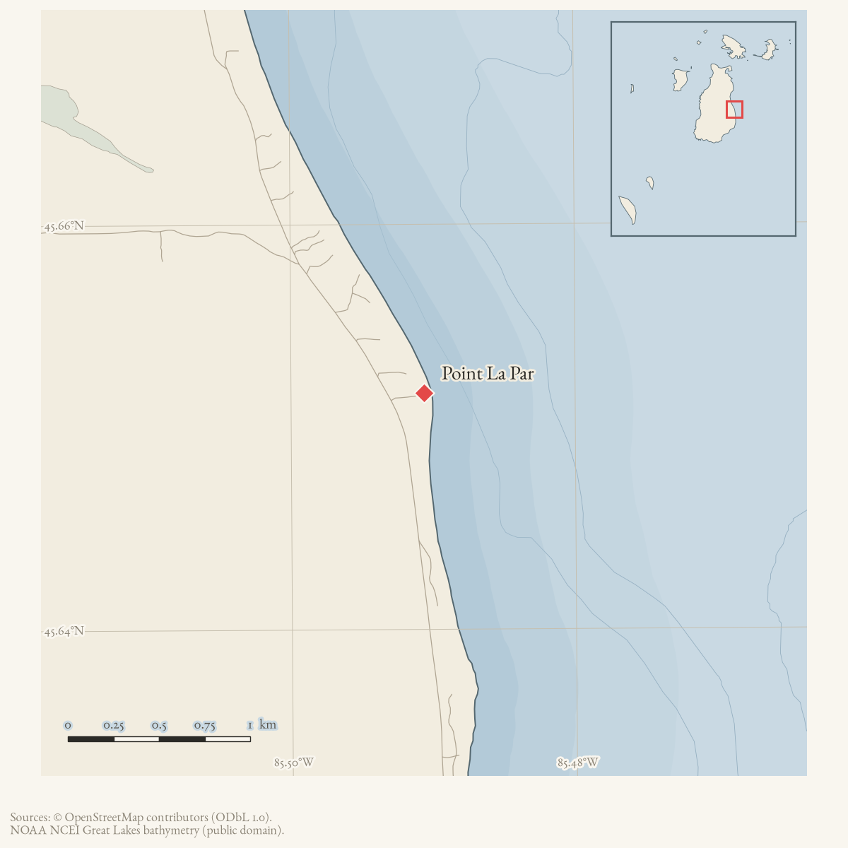
Point La Par is a GNIS-named cape on Beaver Island, near the south end of Sand Bay. A May 1960 local notice states that Richard Stromberg owned property at Point La Par. This is direct evidence that the name was in local use and was associated with private property at that time, but the notice does not establish the property’s boundaries, the origin of the name, or the exact relationship between the cape and the wider Sand Bay shoreline.
The 1978 Historical Map explains the name or significance as the island’s “halfway point by water.” That statement cannot be tested without knowing the starting point, endpoint, travel route, and shoreline convention. It is retained as an attributed map interpretation, not a surveyed or calculated result.
Ecological profile
MNFI Report 2017-11 records a Pointe La Par dry-mesic northern forest occurrence (EO 9259, 387 acres, report p. 49). The report’s spelling differs from the GNIS “Point La Par,” so the two forms are retained rather than silently normalized. The occurrence is a broad dry-mesic forest complex on mildly developed northwest–southeast dune-and-swale topography, not a surveyed outline of the cape or the property mentioned in 1960.
The MNFI occurrence is not a current legal boundary, ownership determination, or complete survey of Point La Par.
The dune ridges have fine-textured acidic sands and thick needle duff. One ridge sample had a 5 cm acidic A horizon (pH 4.5) over medium- to fine-textured acidic dune sands (pH 5.5–6.0). The intervening swales are coarse-textured, wet, and alkaline, with a high water table measured at about 40 cm. That ridge-to-swale contrast is the key soil and hydrology connection: it helps explain why dry pine–oak forest, wooded wetlands, and rich-conifer-swamp inclusions occur in one named occurrence.
The canopy is dominated by red pine and red oak, with supercanopy white pine, aspen clones, southern patches of hemlock, paper birch, and red maple. MNFI cored a red oak 52 cm in diameter at more than 100 years and a northern white-cedar 43 cm in diameter at approximately 150–175 years. Cedar also occurs along the sand ridges near rich conifer swamp inclusions. Balsam fir and red maple are prevalent in the subcanopy and understory, and white pine is prominent in the understory. Blueberries, huckleberry, bracken fern, wintergreen, starflower, wild sarsaparilla, Canada mayflower, bunchberry, and pine and oak seedlings are among the recorded shrub and ground-layer plants. The swales have open-canopy green ash and northern white-cedar, with alder-leaved buckthorn, tussock sedge, sensitive fern, royal fern, and northern bugleweed.
The report interprets the prevalence of balsam fir and red maple as evidence that fire suppression has influenced the site for roughly 50–70 years. It also notes moderate coarse woody debris from senescence and blowdown, logging stumps, a trail through the northwestern portion, and likely historical burning by Native Americans. Deer herbivory may be limiting red-oak regeneration, while continued fire suppression and browse could alter succession. MNFI recommends prescribed fire to favor pine and oak regeneration, monitoring invasive-species encroachment and deer herbivory, reducing deer pressure, and protecting high-quality private forest through acquisition or conservation easements. These are occurrence-level recommendations, not evidence that prescribed fire, acquisition, or a deer reduction program occurred.
Open questions
- What is the origin and earliest documented spelling of “Point La Par”?
- Can the submerged-forest or submerged-net-stakes claim be tested against hydrographic, geological, or dive records? The 2010 forum discussion does not resolve it.
- Can deeds, plats, or historic maps identify the property mentioned in 1960?
- How does the GNIS cape geometry relate to the local use of the name at the south end of Sand Bay?
- How does the MNFI occurrence map relate to the GNIS cape, private property, trail, dune ridges, and wet swales?
Sources
- GNIS feature 635186; feature class 'Cape'.federal · gnis · gnis_names
- A local notice states that Richard Stromberg owned property at Point La Par at the south end of Sand Bay; it documents use of the place-name and a property association but does not define parcel boundaries or title history.data1 · beaver-island-archive · beaver_beacon · 1960-05_Beaver-Beacon
- The held three-page issue scan is paired with the OCR source and confirms the published notice or report; it does not expand the source-specific identity, event, or outcome claims.data1 · beaver-island-archive · scans · beaver_beacon · issues · 1960-05_Beaver-Beacon
- Project-generated MNFI 2017 soil, vegetation, and wildlife crosswalk, preserving MNFI Report 2017-11, Pointe La Par dry-mesic northern forest occurrence (EO 9259), report p. 49.Described in this archive: MNFI soil, vegetation, tree, and wildlife crosswalk, 2017.The 387-acre MNFI occurrence uses the report spelling “Pointe La Par” and is associated with the named cape; it is not a current legal boundary, property determination, or complete survey of the Point La Par shoreline. No public copy of this file is known; the archive holds one and can provide it on request.research · island_farming · crosswalks · mnfi_soil_vegetation_wildlife_crosswalk
- Visual page evidence held with provenance sidecar; the image anchors the occurrence description and does not establish modern geometry or current condition.research · island_farming · evidence · mnfi-report-2017-11-page-0049-pointe-la-par-dry-mesic-forest
- Described in this archive: Beaver Island History Map, 1978 revision.Calls Point La Par the island's halfway point by water. No route definition, shoreline measurement, or period source has yet been found for that explanation.
- A community discussion places Point La Par at the south end of Sand Bay, consistent with the 1960 Beacon notice and the mapped feature. Participants disagreed about a reported submerged forest: one repeated the guide-book claim, another said no forest was known, another referred readers to the dive shop, and a final participant relayed a fisherman's alternative explanation involving submerged net stakes. These are local leads and recollections, not geologic, hydrographic, or archaeological evidence.forum · www.beaverislandforum.com · 02 · t002877
Added 28 July 2026 · revised 7 August 2026. Recent changes
Cite this article
Beaver Island Archive, “Point La Par”, https://beaverislandarchive.org/places/point-la-par/, accessed [date], citing U.S. Geological Survey, Geographic Names Information System, Domestic Names (Michigan), retrieved 2026-07-28. (and 6 further sources listed on the page).
Last revised 2026-08-07. Fill in [date] with the date you read it — this page is static and cannot know that.