

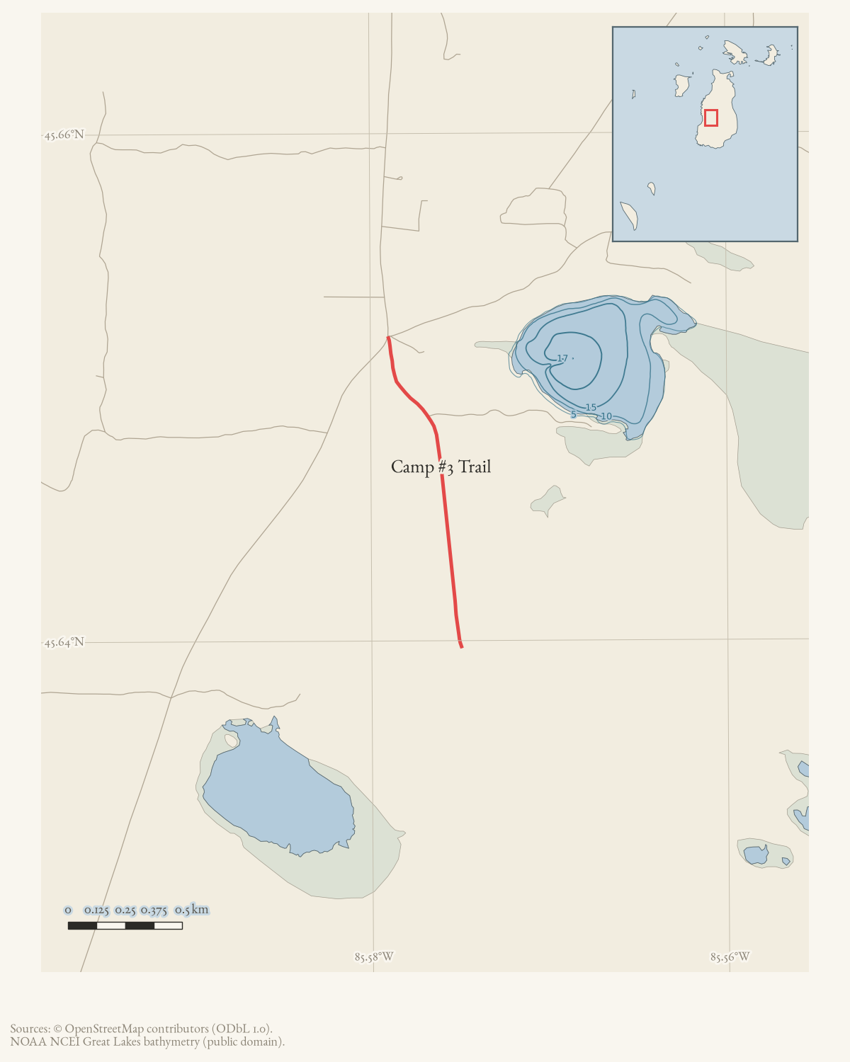
- Intersects
- Fox Lake Road · Fox Pointe Trail · West Side Road
- Coordinates
- 45.6468° N, 85.5760° WGoogle Maps: Camp #3 TrailDownload KML
- Eras
- Modern era
- Concepts
- trailstransportationtoponymy
- Within
- Beaver Island archipelago
Summary
Camp #3 Trail is a named road on Beaver Island’s current OpenStreetMap map.
One held way carries that name, and its geometry is the whole route: about 1.4
km. It meets three other named roads, listed under intersects_road.
Official map sheets: Greene’s/Martin’s to Camp #3 (July 2019) shows the crossing in the wider Greene’s Lake/Johnny Martin’s route. The separate Camp #3 to French Bay sheet (July 2019) is a composite route: it uses Camp Three, Doty’s Camp, North French Bay, and South French Bay trails. It should not be read as assigning that whole composite to Camp #3 Trail.
Evidence and limits
The name and the alignment are what mappers last entered, and OpenStreetMap is
volunteered work rather than a survey: it settles neither the right-of-way nor
who maintains the road. Where the name came from is a separate question. Plats,
road-commission minutes, and island memory answer that one. Put an older
spelling from any of them into alt_names or former_names, with the source
that attests it.
A 2019 walked guide to the island’s trails reached this one and left it blank. Its entry carries the trailhead and the note that there is no parking there, then Description : ? and no distances, while nine other trails in the same document are described in detail. That is not an absence of evidence so much as evidence of a difficulty, and it sits alongside the finding above that the July 2019 trail sheet bearing this trail’s name describes a composite route over four named trails rather than this one.
Access and ownership
Camp #3 Trail is one of the “Middle Trails” Peaine Township’s 2021 narrative guide describes as “former functional roads” that “can be driven with a high clearance vehicle if it has been dry,” running from the intersection of West Side Drive and Fox Lake Road south to a junction with Doty’s Trail. The 2024 Peaine Township Parks and Recreation Plan places much of southern Peaine Township — which this route crosses — within the Beaver Islands State Wildlife Research Area (Michigan DNR); the archive holds no parcel-level record establishing which stretches of Camp #3 Trail specifically fall inside that designation, only the general boundary statement.
The Beaver Island Trail Association’s Greene’s/Martin’s sheet, which also covers trails Camp #3 crosses, states “This is a wilderness area. You may encounter impassable wet areas due to seasonal conditions,” and carries the association’s standard disclaimer that its maps are not official DNR maps and should not be relied on for complete accuracy.
A September 2019 forum post thanking the road crew singled out Camp 3 Trail as being “in excellent shape” that season — a dated resident observation, not a maintenance record or a statement of who is legally responsible for the road.
As walked in 2019. a walked account contributed in 2019 puts the trailhead at the intersection of Fox Lake Road and West Side Road and warns there is no parking at the trailhead, so a walker must find a spot off Fox Lake Road.
Map status
The displayed route is current OSM linework retrieved 2026-08-01, supplemented by the 2015 printed map and 2021 Peaine description. Pending update: confirm the Camp Three/Camp #3 naming equivalence and route condition with a current township or field track.
Open questions
- Who is legally responsible for maintaining Camp #3 Trail — Charlevoix County, Peaine Township, or the DNR? No source held here settles it.
- Is “Camp Three Trail” (the 2015 map’s form) and “Camp #3 Trail” (current OSM) the same route end to end, or has renumbering or realignment changed part of it?
- What was Camp #3 named for — an actual numbered logging or hunting camp, and if so whose? No source in the archive answers this.
If you can answer any of these, or correct anything above, the archive wants to hear it — see Corrections.
Documented associations
These source-backed records provide context for the mapped route:
- Beaver Islands State Wildlife Research Area — Beaver Islands State Wildlife Research Area is a Michigan Department of Natural Resources public-land designation covering substantial state-managed land in the Beaver Island archipelago, dating from the 1970s. Local reporting places 9,195.5 acres of the Beaver Island portion within the 2024…
Research status
The local newspaper and website corpus contains exact-name mentions in 0 file(s). Those files are research leads; the relation layer is added only when the surrounding source text establishes that the record involves this road.
Maps for this place
These Atlas plates provide regional context. They do not establish a precise boundary, current ownership, access right, operating status, or field condition.
- EnvironmentSoils, wetlands, hydrography, and terrain
- GeologyGeneralized geology and landforms
- HydrologyMapped water and wetland context
- AccessMapped routes, facilities, and protected areas
- Land surveyPLSS geometry and historic GLO patent-location context
Sources
- The legend prints “Camp Three Trail,” the visitor-facing form represented by this current Camp #3 Trail entry.
- Describes the Camp #3 route and connections; retrieved 2026-08-02.governance · peaine · trails · all-trail-descriptions
- Current mapped road name 'Camp #3 Trail'; grouped OSM way ids: 17761439. This is a volunteered map record, not a surveyed right-of-way or proof of historical naming.osm · roads
- Three participants praised the road crew and one specifically said Camp 3 Trail was in excellent shape. This is a dated resident observation, not an inspection record, maintenance log, or proof of the route’s legal maintenance responsibility.forum · www.beaverislandforum.com · 14 · t014666
- Section 1 places much of southern Peaine Township, which this route crosses, within the Beaver Islands State Wildlife Research Area (Michigan DNR); the plan gives no parcel-level boundary for this specific trail.governance · peaine · trails · peaine-park-and-rec-plan-draft-2023-11-27
- States 'This is a wilderness area. You may encounter impassable wet areas due to seasonal conditions,' and carries the association's standard disclaimer that its maps are not official DNR maps.governance · peaine · trails · bita-greenes-martin-camp3-trail-2019-07
- The separate Camp #3 sheet identifies a composite route using Camp Three, Doty's Camp, North French Bay, and South French Bay trails; it does not establish that every segment is Camp #3 Trail.governance · peaine · trails · bita-camp3-to-french-bay-trail-2019-07
- Kamrin, Michael. 'An Insiders Guide to Beaver Island Hiking Trails: A Companion to the Wojan/Cashman Beaver Island Map.' Unpublished typescript, created 8 August 2019, last revised 17 February 2020.Walked account — and a BLANK ENTRY. Gives the trailhead as the intersection of Fox Lake Road and West Side Road, with no parking there, then leaves the description as 'Description : ?' and the distances empty. Records the blaze as an orange diamond, shared with Doty's Camp Trail. The gap is evidence: the author described nine other trails and did not describe this one.fieldwork · accounts · kamrin-insiders-guide-bi-hiking-trails
Added 2 August 2026. Recent changes
Cite this article
Beaver Island Archive, “Camp #3 Trail”, https://beaverislandarchive.org/places/camp-3-trail/, accessed [date], citing Beaver Island trails map, revised October 2015. (and 7 further sources listed on the page).
Last revised 2026-08-02. Fill in [date] with the date you read it — this page is static and cannot know that.