

- Coordinates
- 45.7427° N, 85.5088° WGoogle Maps: Whiskey PointDownload KML
- Eras
- Strang eraModern era
- Concepts
- maritimelighthousestoponymyheritageshipping
- Within
- Saint James Harbor · Beaver Island
- Media
- Beaver Island History Map, 1978 revision
Summary
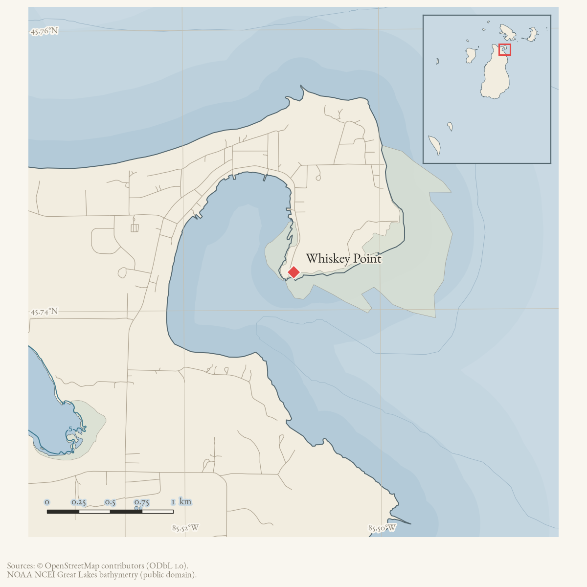
Whiskey Point is the point of land on the north side of the entrance to St. James Harbor on Beaver Island. The Beaver Island Harbor Light stands on it, and the United States Life-Saving Service station stood there as well.1 The name is attested in Quaife’s 1930 history of Strang’s kingdom, where the point is the gentile fishermen’s rendezvous, across the harbour from the Mormon settlement, and the site of the island’s first post office.1
Names
Quaife attributes the name to the fishermen who used the point: “their habits are doubtless responsible for the name attached to the place.”1 That is a secondary account written eighty years after the events it describes, and no earlier attestation of the name has been located. The spelling Whisky Point also occurs; GNIS records the same alternation for the unrelated Whiskey Island further north. A 1976 Beacon historical-map feature list still glossed the point as “The Gentiles’ area,” alongside the Coast Guard light, boathouse and barracks — a modern published echo of the same gentile/Mormon opposition Quaife records for the 1850s.2
Do not confuse Whiskey Point with Whiskey Island, which is a separate feature near Garden Island with its own GNIS record.
In the Strang period
In Quaife’s account the point is the gentile counterweight to Strang’s settlement. The island’s first post office was at the store of the gentile trader there, and Mormons who came for their mail were abused and beaten. In the night of 3 July 1850, while the fishermen were carousing on the point, Mormon spies counted them, spoiled their powder and doped a barrel of whiskey; at daybreak Strang’s men fired a cannon salute whose shot skipped past the point near the trading house.1 These are Quaife’s narrations, drawing on Strang’s own partisan Ancient and Modern Michilimackinac, and Quaife says so himself.
After the Strang period
By the 1870s the point held a commercial fishing and merchandise operation: an October 1963 Beacon Museum Notes item identifies Henry Clifton, who died in 1877, as manager of “the local merchandise and wholesale fish store, known as the Dormer Store, located on Whiskey Point, just past the Coast Guard Station,” and notes that the island museum held a ledger recording the store’s sales from 1876 to 1877.3 The point remained a landmark for boat arrivals into the twentieth century: a May 1962 Beacon anecdote about the ferry Emerald Isle arriving eighteen days late describes its “bow appear[ing] around Whiskey Point” to a crowd waiting at the dock.4
In 1985 the Beaver Island Civic Association raised over $2,700 for a stone and bronze memorial “to the Beaver Islanders lost at sea over the years,” sited, per an April 1986 year-in-review, “out near the lighthouse on Whiskey Point”; dedication activities included a visit and on-board tours from the Coast Guard cutter Mesquite.5
The light and its transfer
The Beaver Island Harbor Light on the point is treated at Beaver Island Harbor Light. In August 2002 the Beaver Beacon called it the island landmark that “represents our rich historical ambiance more than any other,” dated it to 1856 and described the attached brick keeper’s house.6 Restoration and ownership then became island news: a Museum Week 2004 evening programme by the Great Lakes Lighthouse Keepers Association was billed as celebrating “the immanent restoration of the Whiskey Point Light,”7 and in April 2005 the Beacon reported GLLKA’s Dick Moehl pressing for notice of the transfer of the lighthouse deed to St. James Township.8
As a public vantage
The point functions as a place people gather rather than a programmed venue. In
2002 “a party of forty spectators formed at Whiskey Point to wave her past” as a
visiting schooner sailed out of the harbour during Museum Week,6 and in
2003 the Preservation Association invited islanders to watch the solstice
sunrise from Gull Harbor or Whiskey Point before a sunrise breakfast.9
Downstream festival articles may reasonably use took_place_at: [place/whiskey-point] for harbour-side gatherings; they should not assume a
building or a capacity.
Significance
Across more than 170 years of held sources, Whiskey Point functions consistently as the harbor’s threshold: the gentile counterweight to Strang’s Mormon settlement in the 1850s, the site of a wholesale fish and merchandise store by the 1870s, the landmark by which the community judged an overdue ferry’s arrival in the 1960s, the site the Civic Association chose in the mid-1980s for the island’s own memorial to those lost at sea, and the informal public vantage point still used for solstice sunrises and sending off visiting vessels in the 2000s. It has never carried a single institution of its own that outlasted the light and life-saving station, which is likely why it has no GNIS record: the name persists in local and published usage as a description of a stretch of shoreline defined by what has stood on it, not as a formally surveyed feature.
Evidence and limits
geometry_status is approximate and gnis_feature_id is empty. GNIS holds no
Whiskey Point feature in Charlevoix County, and no OpenStreetMap feature in this
project’s extract carries the name. The displayed lighthouse-based coordinate
is a navigation/orientation locator for the point, not the point’s own extent;
it should not be interpreted as a surveyed cape boundary. All newspaper paths
above are in the in-repo data/ tree.
Open questions
- What is the point’s extent, and can a boundary be taken from a NOAA chart or the 1855 Lake Survey sheet rather than from the lighthouse position?
- Why is there no GNIS entry for a named point this prominent in the literature? Is it recorded under another name, or only as part of the harbour?
- Was the deed of the Whiskey Point Light in fact transferred to St. James Township, and when? The held source reports the effort, not the completion.
- What is the earliest documentary attestation of the name? Quaife (1930) is a secondary source; a Strang-era chart, map or letter would be better.
See also
Footnotes
-
Milo M. Quaife, The Kingdom of Saint James (1930), ch. VIII and its footnotes (
data/books/internet_archive/kingdomofsaintja0000milo_y5t1/kingdomofsaintja0000milo_y5t1_djvu.txt). ↩ ↩2 ↩3 ↩4 -
Beaver Beacon, July 1976, historical-map feature list (
/data1/beaver-island-archive/ocr/beaver_beacon/markdown/1976-07_Beaver-Beacon.md). ↩ -
Beaver Beacon, October 1963, “Museum Notes” (
/data1/beaver-island-archive/ocr/beaver_beacon/markdown/1963-10_Beaver-Beacon.md). ↩ -
Beaver Beacon, May 1962, “Better Late Than Never” (
/data1/beaver-island-archive/ocr/beaver_beacon/markdown/1962-05_Beaver-Beacon.md). ↩ -
Beaver Beacon, April 1986, Civic Association year-in-review (
/data1/beaver-island-archive/ocr/beaver_beacon/markdown/1986-04_Beaver-Beacon.md). ↩ -
Beaver Beacon, August 2002 (
/data1/beaver-island-archive/ocr/beaver_beacon/markdown/2002-08_Beaver-Beacon.md). ↩ ↩2 -
Beaver Beacon, July 2004 (
/data1/beaver-island-archive/ocr/beaver_beacon/markdown/2004-07_Beaver-Beacon.md). ↩ -
Beaver Beacon, April 2005 (
/data1/beaver-island-archive/ocr/beaver_beacon/markdown/2005-04_Beaver-Beacon.md). ↩ -
Beaver Beacon, June 2003 (
/data1/beaver-island-archive/ocr/beaver_beacon/markdown/2003-06_Beaver-Beacon.md). ↩
The dated record
Sources
- Described in this archive: Beaver Island History Map, 1978 revision.Prints WHISKEY POINT at the north side of the Saint James Harbor entrance. It corroborates 1978 local usage but supplies no surveyed cape boundary; the article continues to use a qualified lighthouse-based representative point.
- Lighthouse point used as a representative coordinate for Whiskey Point because the held historical source explicitly places the lighthouse and life-saving station there; it is not a surveyed cape boundary.osm · lighthouses_maritime
- PIN 013-226-037-00 is an exempt parcel owned by TOWNSHIP OF ST JAMES, with current situs 37730 Michigan Ave and a representative point within a few meters of the lighthouse-based locator. It supports current public-property context for the point, but does not establish the historical cape boundary or full lighthouse reservation.county · charlevoix · parcels_arcgis · 2026-08-01 · island_parcel_attributes
- Described in this archive: The Kingdom of Saint James, Quaife, 1930.Quaife's footnote reads: "Whiskey Point lay across the harbor from the Mormon settlement, where today the lighthouse and life-saving station are located." The main text says the island's first post office was established at the store of the gentile trader on Whiskey Point, that the fishermen made it their rendezvous, and that "their habits are doubtless responsible for the name attached to the place." Later passages place the fishermen's July 1850 carouse and the trader McKinley's house on the point. Read from the third Internet Archive copy of the 1930 edition; the printed folio for this footnote was not confirmed from a running header, so no page is cited.
- Beaver Beacon, August 2002, "Preserving the Whiskey Point Light."Calls the Whiskey Point Light the island landmark that "represents our rich historical ambiance more than any other," dates its erection to 1856, and notes that a brick keeper's house was attached to it. The 1856 date is the paper's claim; structure/beaver-island-harbor-light records the dating of that light as contested. The same issue reports "a party of forty spectators formed at Whiskey Point to wave her past" as a visiting schooner left the harbour during Museum Week 2002. No public copy of this file is known; the archive holds one and can provide it on request.data1 · beaver-island-archive · beaver_beacon · 2002-08_Beaver-Beacon
- The held thirty-six-page issue scan is paired with the OCR source and confirms the published notice or report; it does not expand the source-specific identity, event, or outcome claims.data1 · beaver-island-archive · scans · beaver_beacon · issues · 2002-08_Beaver-Beacon
- Beaver Beacon, June 2003, "PABI celebrates the Summer Solstice."Invites readers to observe the solstice sunrise "from Gull Harbor, Whiskey Point, or wherever you choose" before a Preservation Association sunrise breakfast. Evidence that the point is used as a public vantage, not a record that anyone gathered there. No public copy of this file is known; the archive holds one and can provide it on request.data1 · beaver-island-archive · beaver_beacon · 2003-06_Beaver-Beacon
- The held thirty-six-page issue scan is paired with the OCR source and confirms the published notice or report; it does not expand the source-specific identity, event, or outcome claims.data1 · beaver-island-archive · scans · beaver_beacon · issues · 2003-06_Beaver-Beacon
- Beaver Beacon, July 2004, Museum Week 2004 schedule.Announces a Tuesday evening Museum Week programme at the Parish Hall by Michele VanderVelde and MaryAnn Moore of the Great Lakes Lighthouse Keepers Association "to celebrate the immanent restoration of the Whiskey Point Light and describe its history." No public copy of this file is known; the archive holds one and can provide it on request.data1 · beaver-island-archive · beaver_beacon · 2004-07_Beaver-Beacon
- The held forty-page issue scan is paired with the OCR source and confirms the published notice or report; it does not expand the source-specific identity, event, or outcome claims.data1 · beaver-island-archive · scans · beaver_beacon · issues · 2004-07_Beaver-Beacon
- Beaver Beacon, April 2005, "An Invitation to Gail Norton."Reports Dick Moehl of the Great Lakes Lighthouse Keepers Association pressing for notification of the transfer of the Whiskey Point Lighthouse deed to St. James Township, and his wish to involve the island schools in a celebration. A report of an ongoing process, not of a completed transfer. No public copy of this file is known; the archive holds one and can provide it on request.data1 · beaver-island-archive · beaver_beacon · 2005-04_Beaver-Beacon
- The held forty-page issue scan is paired with the OCR source and confirms the published notice or report; it does not expand the source-specific identity, event, or outcome claims.data1 · beaver-island-archive · scans · beaver_beacon · issues · 2005-04_Beaver-Beacon
- Identifies Henry Clifton, who died in 1877, as manager of "the local merchandise and wholesale fish store, known as the Dormer Store, located on Whiskey Point, just past the Coast Guard Station"; a Museum ledger book records store sales from 1876 to 1877, and Clifton's burial service was given by George Whitney, said to be the first held by a Protestant minister other than the Mormons. The item also describes a small period burial plot associated with Clifton, which this article does not locate or describe further, consistent with this archive's policy of withholding burial-site locations.data1 · beaver-island-archive · beaver_beacon · 1963-10_Beaver-Beacon
- The held issue scan is paired with the OCR source and confirms the Museum Notes item.data1 · beaver-island-archive · scans · beaver_beacon · issues · 1963-10_Beaver-Beacon
- States the Beaver Island Civic Association raised over $2,700 for "a stone and bronze memorial...to the Beaver Islanders lost at sea over the years," sited "out near the lighthouse on Whiskey Point," and that dedication activities included a visit by the Coast Guard cutter Mesquite for on-board tours. The holding institution's portal restricts automated access; the archive holds a copy of this issue and can provide it on request.data1 · beaver-island-archive · beaver_beacon · 1986-04_Beaver-Beacon
- The held issue scan is paired with the OCR source and confirms the memorial fundraising report.data1 · beaver-island-archive · scans · beaver_beacon · issues · 1986-04_Beaver-Beacon
- A humorous piece recounts the ferry Emerald Isle arriving eighteen days late on 18 April, its "bow appear[ing] around Whiskey Point" to a crowd waiting at the dock -- evidence the point functioned as the visual landmark by which incoming boats were first sighted from town.data1 · beaver-island-archive · beaver_beacon · 1962-05_Beaver-Beacon
- The held issue scan is paired with the OCR source and confirms the arrival anecdote.data1 · beaver-island-archive · scans · beaver_beacon · issues · 1962-05_Beaver-Beacon
- A labeled list identifies "Whiskey Point" with the gloss "(The Gentiles' area)" alongside the Coast Guard Light, Boathouse, and Barracks -- a 1976 published echo of the same gentile/Mormon opposition Quaife records for the 1850s. The holding institution's portal restricts automated access; the archive holds a copy of this issue and can provide it on request.data1 · beaver-island-archive · beaver_beacon · 1976-07_Beaver-Beacon
- The held issue scan is paired with the OCR source and confirms the map feature list.data1 · beaver-island-archive · scans · beaver_beacon · issues · 1976-07_Beaver-Beacon
- Checked for this article: GNIS holds no feature named Whiskey Point in Charlevoix County. The only "Whiskey" feature in the archipelago is Whiskey Island (feature 1616291, class Island, with the variant Whisky Island), which is a different place near Garden Island. The lack of a GNIS record is why this article retains an approximate lighthouse-based locator rather than a mapped point or feature identifier.federal · gnis · gnis_names
Added 3 August 2026 · revised 6 August 2026. Recent changes
Cite this article
Beaver Island Archive, “Whiskey Point”, https://beaverislandarchive.org/places/whiskey-point/, accessed [date], citing Beaver Island Historical Society, Beaver Island History Map, 1978 revision. (and 20 further sources listed on the page).
Last revised 2026-08-06. Fill in [date] with the date you read it — this page is static and cannot know that.